Hamilton County, Nebraska facts for kids
Quick facts for kids
Hamilton County
|
|
|---|---|

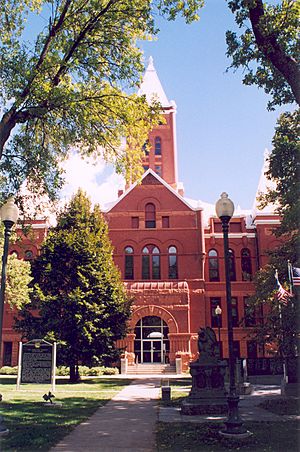
Hamilton County courthouse in Aurora
|
|

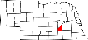
Location within the U.S. state of Nebraska
|
|
 Nebraska's location within the U.S. |
|
| Country | |
| State | |
| Founded | 1867 (created) 1870 (organized) |
| Named for | Alexander Hamilton |
| Seat | Aurora |
| Largest city | Aurora |
| Area | |
| • Total | 547 sq mi (1,420 km2) |
| • Land | 544 sq mi (1,410 km2) |
| • Water | 4.1 sq mi (11 km2) 0.8%% |
| Population
(2020)
|
|
| • Total | 9,429 |
| • Density | 17.238/sq mi (6.655/km2) |
| Time zone | UTC−6 (Central) |
| • Summer (DST) | UTC−5 (CDT) |
| Congressional district | 3rd |
Hamilton County is a place in the state of Nebraska, USA. In 2020, about 9,429 people lived there. The main town, called the county seat, is Aurora. The county was named after Alexander Hamilton. He was an important leader and the first Secretary of the Treasury in the early United States government.
Hamilton County is part of the larger Grand Island area. This area is known as a Metropolitan Statistical Area.
If you look at Nebraska license plates, Hamilton County has the number 28. This means it had the 28th largest number of registered vehicles in 1922. That's when the license plate system started.
Contents
History of Hamilton County
The first people to settle permanently in Hamilton County arrived in 1866. Hamilton County was officially created in 1867. It became an organized county in 1870. As mentioned, it was named after Alexander Hamilton.
Geography of Hamilton County
Hamilton County covers about 547 square miles. Most of this area is land. Only a small part, about 4.1 square miles, is water.
The Platte River flows along the northwest side of the county. It forms the border between Hamilton County and Merrick County.
Main Roads in Hamilton County
These are the major highways that run through Hamilton County:
 Interstate 80
 U.S. Highway 34
 Nebraska Highway 2
 Nebraska Highway 14
 Nebraska Highway 66
Neighboring Counties
Hamilton County shares its borders with these other counties:
- Polk County to the northeast
- York County to the east
- Clay County to the south
- Adams County to the southwest
- Hall County to the west
- Merrick County to the north
Protected Natural Areas
Hamilton County has several protected areas. These places help to protect wildlife and nature.
- Gadwall State Wildlife Management Area
- Nelson Federal Waterfowl Production Area
- Pintail State Wildlife Management Area
- Rainwater Basin Wildlife Management District
- Springer Federal Waterfowl Production Area
- Troester Federal Waterfowl Production Area
- Deep Well State Wildlife Management Area
Population Changes
| Historical population | |||
|---|---|---|---|
| Census | Pop. | %± | |
| 1870 | 130 | — | |
| 1880 | 8,267 | 6,259.2% | |
| 1890 | 14,096 | 70.5% | |
| 1900 | 13,330 | −5.4% | |
| 1910 | 13,459 | 1.0% | |
| 1920 | 13,237 | −1.6% | |
| 1930 | 12,159 | −8.1% | |
| 1940 | 9,982 | −17.9% | |
| 1950 | 8,778 | −12.1% | |
| 1960 | 8,714 | −0.7% | |
| 1970 | 8,867 | 1.8% | |
| 1980 | 9,301 | 4.9% | |
| 1990 | 8,862 | −4.7% | |
| 2000 | 9,403 | 6.1% | |
| 2010 | 9,124 | −3.0% | |
| 2020 | 9,429 | 3.3% | |
| US Decennial Census 1790-1960 1900-1990 1990-2000 2010 |
|||
The population of Hamilton County has changed over many years. In 1870, only 130 people lived there. The population grew a lot by 1890, reaching over 14,000 people. Since then, the number of people living in the county has gone up and down. In 2020, the population was 9,429 people.
Communities in Hamilton County
These are the towns and villages where people live in Hamilton County:
City
- Aurora (This is the county seat, the main town.)
Villages
Census-designated place
Images for kids
See also
 In Spanish: Condado de Hamilton (Nebraska) para niños
 | Emma Amos |
 | Edward Mitchell Bannister |
 | Larry D. Alexander |
 | Ernie Barnes |


