Rainwater Basin facts for kids
Quick facts for kids Rainwater Basin Wetland Management District |
|
|---|---|
|
IUCN Category IV (Habitat/Species Management Area)
|
|
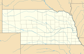
| Location | Nebraska, USA] |
| Nearest city | Kearney, Nebraska |
| Area | 22,864 acres (92.53 km2) |
| Established | 1963 |
| Governing body | U.S. Fish and Wildlife Service |
| Website | Rainwater Basin Wetland Management District |
The Rainwater Basin wetland region is a special area in south-central Nebraska. It covers about 4,200 square miles (10,878 km2). This flat land is south of the Platte River. Long ago, before people settled here, it was covered by prairie grasslands.
Hidden within the grasslands were thousands of small, temporary wetlands. These wetlands are called Rainwater Basins. Locals sometimes call them rainbasins, basins, lagoons, or marshes.
Today, much of the Rainwater Basin area is farmland. Farmers mostly grow corn and soybeans here. Rivers like the Big Blue River also flow through this region. Along these rivers, you can find forests and oak woodlands.
Every spring and fall, millions of migratory birds visit this region. They stop to rest and find food on their long journeys. The Rainwater Basins are a very important part of the Central Flyway. This is a major path for birds across North America.
These unique wetlands get their water only from rain and snow. They are like shallow bowls in the ground. A special layer of clay soil keeps the water from sinking deep into the earth. This means their water levels change a lot. They can be deep lakes after heavy rains or dry patches during droughts.
Contents
What is the Rainwater Basin Wetland Management District?
The Rainwater Basin Wetland Management District helps protect these important wetlands. It was started in 1963. This district includes 61 pieces of land. Most of these are called Waterfowl Production Areas. They cover a total of 22,864 acres (9,252 hectares).
The U.S. Fish and Wildlife Service manages these lands. They are spread across 21 counties in Nebraska. All the land was bought from landowners who wanted to sell. The money came from "duck stamps." These are special stamps that hunters buy each year.
What Birds Live in the Rainwater Basin?
The Rainwater Basin is a fantastic place for birdwatching. Over 257 different kinds of birds have been seen here! Many birds use these wetlands as a vital stopover during their migrations.
Some of the birds you might see include:
- Bald eagle
- Canada goose
- Killdeer
- Least sandpiper
- Mallard
- Northern pintail
- Northern shoveler
- Peregrine falcon
- Piping plover
- Sandhill crane
- Snow goose
- White-fronted goose
- Greater and lesser yellowlegs
How Were Rainwater Basins Formed?
The Rainwater Basins are subtle dips in the land. Most of them are south of the Platte River. Before European settlers arrived, there were almost 4,000 of these wetlands. They covered about 40,500 hectares (100,000 acres).
The smaller basins are usually irregular in shape. They range from about 0.1 to 30 hectares (0.25 to 74 acres) in size. Their lowest points are usually less than 3 feet (0.9 meters) below the land around them. Sadly, many of these smaller basins have been destroyed. They were filled in or drained for farming.
The larger basins are often oval or stretched-out shapes. They can be about 0.4 to 0.9 miles (0.6 to 1.4 km) wide and 0.9 to 1.5 miles (1.4 to 2.4 km) long. Most of these basins are closed. This means they hold rainwater runoff from the surrounding area. This forms seasonal lakes and wetlands.
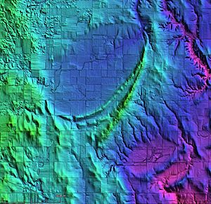
Some basins have been naturally "breached." This means they now drain to an outside river and no longer hold water. Many large oval Rainwater Basins have a crescent-shaped ridge on their southeast side. These ridges are called lunettes. They can be about 15 to 50 feet (4.5 to 15 meters) high.
Since people settled in this area, about 90% of these wetlands have disappeared. Many were drained to create more farmland. Luckily, many of the remaining wetlands are now protected. Government groups and non-profit organizations have set aside 84 publicly owned Rainwater Basin sites. These sites protect about 11,600 hectares (28,664 acres) of wildlife habitat.
How Old Are the Rainwater Basins?
The large oval Rainwater Basins we see today are actually the tops of much older depressions. These older depressions formed in ancient river sands and gravels. Over time, layers of fine dust, called loess, covered these older basins. This loess layer is about 2.5 to 8 meters (8 to 26 feet) thick.
Scientists have studied these layers of loess and the soils within them. They use special dating methods like radiocarbon dating and optically stimulated luminescence dating. These methods help them figure out how old the layers are.
The oldest loess covering the original Rainwater Basins is about 28,000 to 36,000 years old. The river sands beneath the loess are even older, about 36,000 to 50,000 years old. This tells us that the Rainwater Basins started forming a very long time ago. They were created before the last major ice age, called the Middle Wisconsinan.
This means the Rainwater Basins and their crescent-shaped ridges are very old landforms. They have slowly moved upwards in elevation as new layers of loess built up over thousands of years.
See also
 In Spanish: Cuencas Pluviales de Nebraska para niños
 | Delilah Pierce |
 | Gordon Parks |
 | Augusta Savage |
 | Charles Ethan Porter |


