Saline County, Nebraska facts for kids
Quick facts for kids
Saline County
|
|
|---|---|
| County of Saline | |

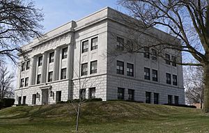
Saline County Courthouse in Wilber
|
|

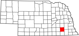
Location within the U.S. state of Nebraska
|
|
| Country | |
| State | |
| Established | March 16, 1855 |
| Organized | February 18, 1867 |
| County seat | Wilber |
| Largest city | Crete |
| Area | |
| • Total | 576 sq mi (1,490 km2) |
| • Land | 574 sq mi (1,490 km2) |
| • Water | 2.3 sq mi (6 km2) |
| Population
(2020)
|
|
| • Total | 14,292 |
| • Density | 24.813/sq mi (9.580/km2) |
| Time zone | UTC−6 (Central) |
| • Summer (DST) | UTC−5 (CDT) |
| Area code | 402/531 |
| FIPS code | 31151 |
| GNIS feature ID | 835897 |
| Website | www.co.saline.ne.us |
Saline County is a county located in the state of Nebraska in the United States. As of 2020, about 14,292 people live here. The main town and county seat is Wilber.
When you see Nebraska license plates, Saline County is shown by the number 22. This is because it had the twenty-second highest number of registered vehicles back in 1922 when the system started.
Contents
History of Saline County
Saline County was officially created in 1855. It started to be organized as a county in 1867. The very first person to settle here permanently arrived in 1858.
Geography of Saline County
The land in Saline County has gentle, rolling hills. These hills slope downwards towards the east and southeast. Most of the county's land is used for farming.
The Big Blue River flows south through the eastern part of the county. Smaller streams like Swan Creek and Turkey Creek drain the middle and southern areas. These streams join together and flow into the Big Blue River near the county's eastern edge.
The county covers about 576 square miles. Most of this area, about 574 square miles, is land. A small part, about 2.3 square miles, is water.
Main Roads in Saline County
Neighboring Counties
- Lancaster County – to the northeast
- Gage County – to the southeast
- Jefferson County – to the south
- Thayer County – to the southwest
- Fillmore County – to the west
- York County – to the northwest
- Seward County – to the north
Protected Natural Areas
- Willard Meyer Natural Resource District - Swan Lake is a special area here.
Population of Saline County
| Historical population | |||
|---|---|---|---|
| Census | Pop. | %± | |
| 1860 | 39 | — | |
| 1870 | 3,106 | 7,864.1% | |
| 1880 | 14,491 | 366.5% | |
| 1890 | 20,097 | 38.7% | |
| 1900 | 18,252 | −9.2% | |
| 1910 | 17,866 | −2.1% | |
| 1920 | 16,514 | −7.6% | |
| 1930 | 16,536 | 0.1% | |
| 1940 | 15,010 | −9.2% | |
| 1950 | 14,046 | −6.4% | |
| 1960 | 12,542 | −10.7% | |
| 1970 | 12,809 | 2.1% | |
| 1980 | 13,131 | 2.5% | |
| 1990 | 12,715 | −3.2% | |
| 2000 | 13,843 | 8.9% | |
| 2010 | 14,200 | 2.6% | |
| 2020 | 14,292 | 0.6% | |
| US Decennial Census 1790-1960 1900-1990 1990-2000 2010 |
|||
In 2000, there were 13,843 people living in Saline County. These people lived in 5,188 homes. About 3,507 of these homes were families.
The population density was about 24 people per square mile. There were about 5,611 housing units in total.
About 25.1% of the people in the county were under 18 years old. About 17.2% were 65 years old or older. The average age of people in the county was 36 years.
Communities in Saline County
Cities
Villages
Unincorporated Communities
These are smaller places that are not officially cities or villages.
Education in Saline County
Students in Saline County attend schools in several different school districts:
- Crete Public Schools
- Exeter-Milligan Public Schools
- Dorchester Public Schools
- Friend Public Schools
- Meridian Public Schools
- Milford Public Schools
- Tri County Public Schools
- Wilber-Clatonia Public Schools
See also
 In Spanish: Condado de Saline (Nebraska) para niños
 | Dorothy Vaughan |
 | Charles Henry Turner |
 | Hildrus Poindexter |
 | Henry Cecil McBay |

