
Lancaster County, Nebraska facts for kids
Quick facts for kids
Lancaster County
|
|||
|---|---|---|---|

Lancaster County Courthouse in Lincoln
|
|||
|
|||

Location within the U.S. state of Nebraska
|
|||
 Nebraska's location within the U.S. |
|||
| Country | |||
| State | |||
| Founded | 1859 | ||
| Named for | Lancaster, England | ||
| Seat | Lincoln | ||
| Largest city | Lincoln | ||
| Area | |||
| • Total | 846 sq mi (2,190 km2) | ||
| • Land | 838 sq mi (2,170 km2) | ||
| • Water | 8.8 sq mi (23 km2) 1.0%% | ||
| Population
(2020)
|
|||
| • Total | 322,608 | ||
| • Density | 381.33/sq mi (147.23/km2) | ||
| Time zone | UTC−6 (Central) | ||
| • Summer (DST) | UTC−5 (CDT) | ||
| Congressional district | 1st | ||


Lancaster County is a county in the state of Nebraska, USA. It is home to Lincoln, which is the capital city of Nebraska.
In 2020, about 322,608 people lived here. This makes it the second-largest county in Nebraska by population. Lancaster County was created in 1859.
Contents
Exploring Lancaster County's Geography
Lancaster County covers a total area of about 846 square miles. Most of this area, 838 square miles, is land. The remaining 8.8 square miles is water, like lakes and rivers.
Major Roads and Travel Routes
Many important roads run through Lancaster County. These roads help people travel easily across the county and to other parts of Nebraska.
 Interstate 80
 Interstate 180
 U.S. Highway 6
 U.S. Highway 34
 U.S. Highway 77
 Nebraska Highway 2
 Nebraska Highway 33
 Nebraska Highway 43
 Nebraska Highway 79
You can also travel by train or bus in Lancaster County.
- Amtrak California Zephyr (stops at the Lincoln station)
- Burlington Trailways (bus service)
- Express Arrow (bus service)
- StarTran (local bus service in Lincoln)
Weather and Climate Safety
Lancaster County is known for being prepared for severe weather. In 2004, the National Weather Service named it a "StormReady" county. This means the county has plans and systems to warn people about dangerous weather.
Neighboring Counties
Lancaster County shares borders with several other counties in Nebraska.
- Saunders County – to the north
- Cass County – to the northeast
- Otoe County – to the southeast
- Johnson County – to the southeast
- Gage County – to the south
- Saline County – to the southwest
- Seward County – to the northwest
- Butler County – to the northwest
Parks and Recreation Areas
Lancaster County has many beautiful parks and recreation areas. These places are great for outdoor activities like fishing, hiking, and camping.
- Bluestem Lake State Recreation Area
- Branched Oak State Recreation Area
- Conestoga Lake State Recreation Area
- Frank Shoemaker Marsh
- Holmes Lake Recreation Area
- Olive Creek Lake State Recreation Area
- Pawnee State Recreation Area
- Pioneers Park Nature Center
- Stagecoach Lake State Recreation Area
- Wagon Train Lake State Recreation Area
- Wildwood Lake State Wildlife Management Area
- Yankee Hill State Wildlife Management Area
Population and People of Lancaster County
The number of people living in Lancaster County has grown a lot over the years.
| Historical population | |||
|---|---|---|---|
| Census | Pop. | %± | |
| 1860 | 153 | — | |
| 1870 | 7,074 | 4,523.5% | |
| 1880 | 28,090 | 297.1% | |
| 1890 | 76,395 | 172.0% | |
| 1900 | 64,835 | −15.1% | |
| 1910 | 73,793 | 13.8% | |
| 1920 | 85,902 | 16.4% | |
| 1930 | 100,324 | 16.8% | |
| 1940 | 100,585 | 0.3% | |
| 1950 | 119,742 | 19.0% | |
| 1960 | 155,272 | 29.7% | |
| 1970 | 167,972 | 8.2% | |
| 1980 | 192,884 | 14.8% | |
| 1990 | 213,641 | 10.8% | |
| 2000 | 250,291 | 17.2% | |
| 2010 | 285,407 | 14.0% | |
| 2020 | 322,608 | 13.0% | |
| 2023 (est.) | 326,716 | 14.5% | |
| US Decennial Census 1790–1960 1900–1990 1990–2000 2010 |
|||
Who Lives in Lancaster County?
According to the 2020 Census, there were 322,608 people living in the county. The population density was about 381 people per square mile.
Most people in the county are White (79.7%). Other groups include Black or African American (4.5%), Asian American (4.7%), and Native American (1.0%). About 3.3% of people are from two or more racial backgrounds. Also, 8.1% of the population identifies as Hispanic or Latino.
Cities and Towns in Lancaster County
Lancaster County has several cities and smaller towns, called villages.
Cities
- Bennet
- Hickman
- Lincoln (This is the county seat, where the main county government offices are.)
- Waverly
Villages
Other Communities
There are also other smaller communities that are not officially cities or villages. Some of these are called "census-designated places" (CDPs).
- Agnew (CDP)
- Cheney (CDP)
- Emerald (CDP)
- Kramer (CDP)
- Martell (CDP)
- Prairie Home (CDP)
- Princeton (CDP)
- Walton (CDP)
- Yankee Hill (CDP)
- Arbor (unincorporated)
- Berks (unincorporated)
- Holland (unincorporated)
- Rokeby (unincorporated)
- Saltillo (unincorporated)
Education in Lancaster County
Many school districts serve the students of Lancaster County. These districts provide education from elementary to high school.
- Crete Public Schools
- Freeman Public Schools
- Lincoln Public Schools
- Malcolm Public Schools
- Milford Public Schools
- Norris School District 160
- Palmyra District OR-1
- Raymond Central Public Schools
- Waverly School District 145
- Wilber-Clatonia Public Schools
Notable People from Lancaster County
- Leon Riley (1906–1970) was a professional baseball player and manager. He was born in Princeton, Nebraska, which is in Lancaster County.
Images for kids
-
The official flag of Lancaster County.
-
The official seal of Lancaster County.
-
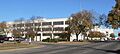
The Lancaster County Courthouse in Lincoln.
See also
 In Spanish: Condado de Lancaster (Nebraska) para niños
