Butler County, Nebraska facts for kids
Quick facts for kids
Butler County
|
|
|---|---|
| County of Butler | |

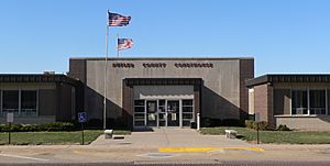
Butler County Courthouse in David City
|
|

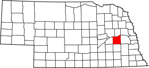
Location within the U.S. state of Nebraska
|
|
| Country | |
| State | |
| Established | January 26, 1856 |
| Organized | October 21, 1868 |
| Named for | William Orlando Butler |
| County seat | David City |
| Largest city | David City |
| Area | |
| • Total | 591 sq mi (1,530 km2) |
| • Land | 585 sq mi (1,520 km2) |
| • Water | 5.9 sq mi (15 km2) 1.0% |
| Highest elevation | 1,739 ft (530 m) |
| Lowest elevation | 902 ft (275 m) |
| Population | |
| • Estimate
(2021)
|
8,369 |
| • Density | 13.8/sq mi (5.3/km2) |
| Time zone | UTC−6 (Central) |
| • Summer (DST) | UTC−5 (CDT) |
| Area code | 402/531 |
| FIPS code | 31023 |
| GNIS feature ID | 835833 |
| Website | www.co.butler.ne.us |
Butler County is a special area in the state of Nebraska, USA. It's like a big neighborhood with its own local government. As of 2020, about 8,369 people live here. The main town, or county seat, is David City. Butler County was officially created in 1856 and started its government in 1868.
If you see a Nebraska license plate with the number 25, it means the car is from Butler County! This number was given because Butler County had the 25th highest number of registered cars in Nebraska back in 1922. Also, in 2010, the very center of Nebraska's population was found right here in Butler County, close to a village called Rising City.
Contents
How Butler County Got Its Name
There's a little mystery about how Butler County got its name! Most people agree it was named after William Orlando Butler. He was a famous person from Kentucky. He was a U.S. congressman and a U.S. Army major general during the Mexican–American War.
In 1854, President Franklin Pierce asked William Orlando Butler to be the Governor of Nebraska Territory. Even though he said no, the county was still named in his honor. The name "Butler County" first appeared in official Nebraska records around 1857 and 1858.
Some people thought the county was named after David Butler, who became the first Governor of the State of Nebraska. However, Butler County was created in 1856, more than ten years before David Butler became governor. He didn't even move to Nebraska until 1859. So, it's very unlikely the county was named after him.
Geography of Butler County
Butler County is located in the state of Nebraska. It covers a total area of about 591 square miles. Most of this area, about 585 square miles, is land. The rest, about 5.9 square miles, is water.
Main Roads in Butler County
Here are the major highways that run through Butler County:
 U.S. Highway 81
 Nebraska Highway 15
 Nebraska Highway 64
 Nebraska Highway 66
 Nebraska Highway 92
Neighboring Counties
Butler County shares its borders with several other counties:
- Saunders County – to the east
- Seward County – to the south
- York County – to the southwest
- Polk County – to the west
- Platte County – to the northwest
- Colfax County – to the north
Population Facts
| Historical population | |||
|---|---|---|---|
| Census | Pop. | %± | |
| 1860 | 27 | — | |
| 1870 | 1,290 | 4,677.8% | |
| 1880 | 9,194 | 612.7% | |
| 1890 | 15,454 | 68.1% | |
| 1900 | 15,703 | 1.6% | |
| 1910 | 15,403 | −1.9% | |
| 1920 | 14,606 | −5.2% | |
| 1930 | 14,410 | −1.3% | |
| 1940 | 13,106 | −9.0% | |
| 1950 | 11,432 | −12.8% | |
| 1960 | 10,312 | −9.8% | |
| 1970 | 9,461 | −8.3% | |
| 1980 | 9,330 | −1.4% | |
| 1990 | 8,601 | −7.8% | |
| 2000 | 8,767 | 1.9% | |
| 2010 | 8,395 | −4.2% | |
| 2020 | 8,369 | −0.3% | |
| 2021 (est.) | 8,444 | 0.6% | |
| US Decennial Census 1790-1960 1900-1990 1990-2000 2010-2013 |
|||
As of the year 2000, there were 8,767 people living in Butler County. These people lived in 3,426 households. Most people in the county were White (98.38%). The main backgrounds of people living here were German (33.1%) and Czech (32.0%).
About 33% of households had children under 18 living with them. Many households (59.9%) were married couples living together. The average household had about 2.53 people.
The median age in the county was 39 years old. This means half the people were younger than 39 and half were older. About 27.9% of the population was under 18 years old.
Towns and Villages
Butler County has one city and several villages and smaller communities.
City
- David City (This is the county seat, meaning it's where the main county government offices are.)
Villages
Unincorporated Communities
These are smaller places that don't have their own local government like cities or villages:
Ghost Town
- Savannah (A ghost town is a place where people used to live, but now it's mostly empty.)
Townships
Townships are smaller areas within a county, often used for local administration.
- Alexis
- Bone Creek
- Center
- Franklin
- Linwood
- Oak Creek
- Olive
- Platte
- Plum Creek
- Read
- Reading
- Richardson
- Savannah
- Skull Creek
- Summit
- Ulysses
- Union
See also
 In Spanish: Condado de Butler (Nebraska) para niños
 | Mary Eliza Mahoney |
 | Susie King Taylor |
 | Ida Gray |
 | Eliza Ann Grier |

