Saunders County, Nebraska facts for kids
Quick facts for kids
Saunders County
|
|
|---|---|
| County of Saunders | |

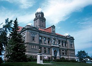
Saunders County Courthouse in Wahoo
|
|

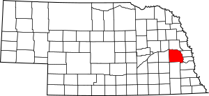
Location within the U.S. state of Nebraska
|
|
| Country | |
| State | |
| Established | January 26, 1856 |
| Organized | October 8, 1867 |
| Named for | Alvin Saunders |
| County seat | Wahoo |
| Largest city | Wahoo |
| Area | |
| • Total | 760 sq mi (2,000 km2) |
| • Land | 750 sq mi (1,900 km2) |
| • Water | 9.6 sq mi (25 km2) 1.3% |
| Highest elevation | 1,365 ft (416 m) |
| Lowest elevation | 866 ft (264 m) |
| Population | |
| • Estimate
(2022)
|
23,118 |
| • Density | 30.8/sq mi (11.9/km2) |
| Time zone | UTC−6 (Central) |
| • Summer (DST) | UTC−5 (CDT) |
| Area code | 402/531 |
| FIPS code | 31155 |
| GNIS feature ID | 835899 |
| Website | saunderscounty.ne.gov |
Saunders County is a county located in the state of Nebraska, United States. It's a place where many people live and work. In 2020, about 22,278 people called Saunders County home. The main town, or county seat, where the county government is located, is Wahoo.
Saunders County is part of the larger Omaha–Council Bluffs metropolitan area. This means it's connected to the bigger cities of Omaha and Council Bluffs.
If you see a Nebraska license plate, Saunders County vehicles used to have the number 6 at the start. This was because it had the sixth-highest number of registered vehicles in the state back in 1922.
Contents
History of Saunders County
Saunders County was officially created by the Nebraska Territorial Legislature in 1856. It started to be organized in 1866. Its borders were changed a bit in 1858.
The county was first named Calhoun County. This name honored John Calhoun, who was a surveyor for Kansas and Nebraska. Some people think it was named after John C. Calhoun from South Carolina.
During the American Civil War in 1862, the county's name was changed. It was renamed Saunders County after Alvin Saunders, who was the governor of the Nebraska Territory at that time.
Geography of Saunders County
Saunders County is located in eastern Nebraska. The Platte River forms its northern and eastern borders. Many small streams and rivers flow through the county, carrying water eastward into the Platte River.
The land in Saunders County has gentle, rolling hills. These hills slope down towards the river valley in the east and northeast. The county covers about 760 square miles (1,968 square kilometers). Most of this area, about 750 square miles (1,942 square kilometers), is land. The rest, about 9.6 square miles (25 square kilometers), is water.
Main Roads in Saunders County
Neighboring Counties
- Douglas County – to the east
- Sarpy County – to the east
- Cass County – to the southeast
- Lancaster County – to the south
- Butler County – to the west
- Dodge County – to the north
Parks and Wildlife Areas
- Bramble State Wildlife Management Area
- Czechland Lake Recreation and Wildlife Management Area
- Jack Sinn Memorial State Wildlife Management Area
- Memphis Lake State Recreation Area
- Pioneer State Recreation Area
Population of Saunders County
| Historical population | |||
|---|---|---|---|
| Census | Pop. | %± | |
| 1870 | 4,547 | — | |
| 1880 | 15,810 | 247.7% | |
| 1890 | 21,577 | 36.5% | |
| 1900 | 22,085 | 2.4% | |
| 1910 | 21,179 | −4.1% | |
| 1920 | 20,589 | −2.8% | |
| 1930 | 20,167 | −2.0% | |
| 1940 | 17,892 | −11.3% | |
| 1950 | 16,923 | −5.4% | |
| 1960 | 17,270 | 2.1% | |
| 1970 | 17,018 | −1.5% | |
| 1980 | 18,716 | 10.0% | |
| 1990 | 18,285 | −2.3% | |
| 2000 | 19,830 | 8.4% | |
| 2010 | 20,780 | 4.8% | |
| 2020 | 22,278 | 7.2% | |
| 2023 (est.) | 23,463 | 12.9% | |
| US Decennial Census 1790–1960 1900–1990 1990–2000 2010 |
|||
In 2020, the United States Census counted 22,278 people living in Saunders County. There were 8,789 households, which are groups of people living together in one home.
The population density was about 29 people for every square mile. This tells us how crowded an area is. There were also about 10,424 housing units, like houses or apartments.
Most people in the county, about 96.7%, identified as White. Smaller groups included Black or African American (0.7%), Native American (0.5%), and Asian (0.5%). About 2.6% of the population identified as Hispanic or Latino.
Towns and Villages in Saunders County
Saunders County has several cities and smaller communities.
Cities
Villages
Census-Designated Place
- Wann (This is a community that is counted in the census but isn't an official city or village.)
Townships
- Ashland
- Bohemia
- Center
- Chapman
- Chester
- Clear Creek
- Douglas
- Elk
- Green
- Leshara
- Marble
- Marietta
- Mariposa
- Morse Bluff
- Newman
- North Cedar
- Oak Creek
- Pohocco
- Richland
- Rock Creek
- South Cedar
- Stocking
- Union
- Wahoo
See also
 In Spanish: Condado de Saunders para niños
 | Madam C. J. Walker |
 | Janet Emerson Bashen |
 | Annie Turnbo Malone |
 | Maggie L. Walker |


