Ceresco, Nebraska facts for kids
Quick facts for kids
Ceresco, Nebraska
|
|
|---|---|
|
Village
|
|

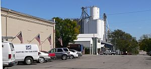
Downtown Ceresco, September 2011
|
|

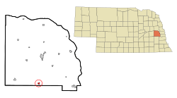
Location of Ceresco, Nebraska
|
|
| Country | United States |
| State | Nebraska |
| County | Saunders |
| Township | Richland |
| Area | |
| • Total | 0.45 sq mi (1.16 km2) |
| • Land | 0.45 sq mi (1.16 km2) |
| • Water | 0.00 sq mi (0.00 km2) |
| Elevation | 1,224 ft (373 m) |
| Population
(2020)
|
|
| • Total | 919 |
| • Density | 2,060.54/sq mi (795.22/km2) |
| Time zone | UTC-6 (Central (CST)) |
| • Summer (DST) | UTC-5 (CDT) |
| ZIP code |
68017
|
| Area code(s) | 402 |
| FIPS code | 31-08570 |
| GNIS feature ID | 2397593 |
Ceresco is a small village in Saunders County, Nebraska, United States. It's mostly a farming community. In 2020, about 919 people lived there.
Ceresco is located close to U.S. Highway 77. It's just north of Lincoln and south of Wahoo. It's also not too far southwest of Omaha.
Contents
About Ceresco, Nebraska
Ceresco was started in 1886. This happened when the Fremont, Elkhorn & Missouri Valley Railroad built tracks to that spot. The village got its name from Ceresco, Michigan. Some of the first people to settle here, Richard Nelson and Hod Andrus, were from that town.
The village has a public library where you can find books. There's also a public park for outdoor fun. Ceresco has three Protestant churches.
Schools and Services
Ceresco has an elementary school for younger students. After elementary school, students go to the Raymond Central School District. Most of the roads in Ceresco are paved.
The village has a small police department with a few part-time officers. It also has a fire department with four fire trucks. The village is run by a group called a village board. This board hires a city engineer to help with village planning. Ceresco does not have its own hospitals or large factories.
Where is Ceresco?
Ceresco is located in the state of Nebraska. It covers a total area of about 1.16 square kilometers (0.45 square miles). All of this area is land.
Population of Ceresco
The number of people living in Ceresco has changed over the years. Here's how the population has grown:
- 1890: 211 people
- 1900: 226 people
- 1910: 296 people
- 1920: 398 people
- 1930: 391 people
- 1940: 342 people
- 1950: 374 people
- 1960: 429 people
- 1970: 474 people
- 1980: 836 people
- 1990: 825 people
- 2000: 920 people
- 2010: 889 people
- 2020: 919 people
Ceresco in 2010
In 2010, there were 889 people living in Ceresco. There were 333 homes, and 256 of these were families. Most people living in Ceresco were White (98.7%). A small number of people were from other racial backgrounds. About 0.7% of the population was of Hispanic or Latino origin.
The average age of people in Ceresco was about 35.6 years old. About 28.7% of the residents were under 18 years old. About half of the population was male (50.3%) and half was female (49.7%).
See also
 In Spanish: Ceresco (Nebraska) para niños
 | Mary Eliza Mahoney |
 | Susie King Taylor |
 | Ida Gray |
 | Eliza Ann Grier |


