Dodge County, Nebraska facts for kids
Quick facts for kids
Dodge County
|
|
|---|---|

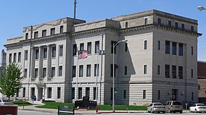
Dodge County Courthouse in Fremont
|
|

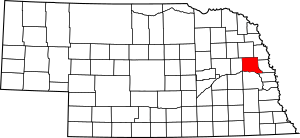
Location within the U.S. state of Nebraska
|
|
 Nebraska's location within the U.S. |
|
| Country | |
| State | |
| Founded | 1855 |
| Named for | Augustus C. Dodge |
| Seat | Fremont |
| Largest city | Fremont |
| Area | |
| • Total | 543 sq mi (1,410 km2) |
| • Land | 529 sq mi (1,370 km2) |
| • Water | 14 sq mi (40 km2) 2.6%% |
| Population
(2020)
|
|
| • Total | 37,167 |
| • Density | 68.45/sq mi (26.428/km2) |
| Time zone | UTC−6 (Central) |
| • Summer (DST) | UTC−5 (CDT) |
| Congressional district | 1st |
Dodge County is a county located in the state of Nebraska in the United States. As of the 2020 United States Census, about 37,167 people lived here. The main city and government center, called the county seat, is Fremont.
Dodge County was created in 1855. It was named after Augustus C. Dodge, who was a Senator from Iowa. The county is part of a larger area that includes Omaha and Council Bluffs.
If you look at Nebraska license plates, Dodge County is shown by the number 5. This is because it had the fifth-highest number of registered vehicles when the license plate system started in 1922.
Contents
Geography of Dodge County
Dodge County has a total area of 543 square miles (1,410 km2). Most of this area, 529 square miles (1,370 km2), is land. The remaining 14 square miles (36 km2) (which is about 2.6%) is covered by water.
The Elkhorn River flows through the northeast part of Dodge County. This river eventually drains into the Platte River. The Platte River itself runs along the southern border of Dodge County.
Main Roads in Dodge County
Several important highways pass through Dodge County, making it easy to travel.
Neighboring Counties
Dodge County shares its borders with several other counties.
- Burt County – to the northeast
- Washington County – to the east
- Douglas County – to the southeast
- Saunders County – to the south
- Colfax County – to the west
- Cuming County – to the north
People of Dodge County
The number of people living in Dodge County has changed over many years. Here is a look at the population from past censuses:
| Historical population | |||
|---|---|---|---|
| Census | Pop. | %± | |
| 1860 | 309 | — | |
| 1870 | 4,212 | 1,263.1% | |
| 1880 | 11,263 | 167.4% | |
| 1890 | 19,260 | 71.0% | |
| 1900 | 22,298 | 15.8% | |
| 1910 | 22,145 | −0.7% | |
| 1920 | 23,197 | 4.8% | |
| 1930 | 25,273 | 8.9% | |
| 1940 | 23,799 | −5.8% | |
| 1950 | 26,265 | 10.4% | |
| 1960 | 32,471 | 23.6% | |
| 1970 | 34,782 | 7.1% | |
| 1980 | 35,847 | 3.1% | |
| 1990 | 34,500 | −3.8% | |
| 2000 | 36,160 | 4.8% | |
| 2010 | 36,691 | 1.5% | |
| 2020 | 37,167 | 1.3% | |
| 2023 (est.) | 37,187 | 1.4% | |
| US Decennial Census | |||
In 2000, there were 36,160 people living in the county. The population density was about 68 people for every square mile. Most people identified as White, but there were also people of Black, Native American, Asian, and Pacific Islander backgrounds. Some people identified with two or more races. About 3.93% of the population was Hispanic or Latino.
The average age of people in the county in 2000 was 38 years old. About 24.7% of the population was under 18 years old.
Cities and Towns in Dodge County
Dodge County is home to several cities and smaller communities.
Cities
These are the larger cities in Dodge County:
- Fremont (This is the county seat, where the main government offices are)
- Hooper
- North Bend
- Scribner
Villages
These are smaller towns, often called villages:
Census-designated place
Other Communities
These are smaller, unincorporated communities that don't have their own local government:
Past Cities
- Jalapa
See also
 In Spanish: Condado de Dodge (Nebraska) para niños
 | DeHart Hubbard |
 | Wilma Rudolph |
 | Jesse Owens |
 | Jackie Joyner-Kersee |
 | Major Taylor |

