Burt County, Nebraska facts for kids
Quick facts for kids
Burt County
|
|
|---|---|

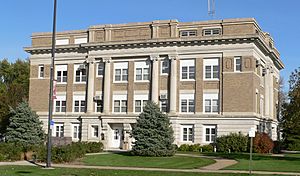
Burt County Courthouse in Tekamah
|
|

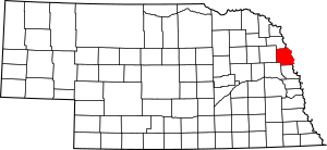
Location within the U.S. state of Nebraska
|
|
 Nebraska's location within the U.S. |
|
| Country | |
| State | |
| Founded | 1854 |
| Named for | Francis Burt |
| Seat | Tekamah |
| Largest city | Tekamah |
| Area | |
| • Total | 497 sq mi (1,290 km2) |
| • Land | 492 sq mi (1,270 km2) |
| • Water | 5.5 sq mi (14 km2) 1.1%% |
| Population
(2020)
|
|
| • Total | 6,722 |
| • Density | 13.525/sq mi (5.222/km2) |
| Time zone | UTC−6 (Central) |
| • Summer (DST) | UTC−5 (CDT) |
| Congressional district | 3rd |
Burt County is a county in the state of Nebraska. It is located on the western side of the upper Missouri River. In 2020, about 6,722 people lived there. The main town and county seat is Tekamah. Burt County was created in 1854. It was named after Francis Burt, who was the first governor of the Nebraska Territory.
In the Nebraska license plate system, Burt County has a special number. Its number is 31. This is because it had the 31st largest number of vehicles registered in the county. This system started in 1922.
Contents
Geography of Burt County
Burt County covers about 497 square miles (1,287 square kilometers). Most of this area is land, about 492 square miles (1,274 square kilometers). A small part, about 5.5 square miles (14 square kilometers), is water.
The eastern border of Burt County is next to the state of Iowa. This border mostly follows the Missouri River. Over time, the river has changed its path. Because of this, some small parts of Burt County are now on the eastern side of the river.
Main Roads in Burt County
These are the most important roads that go through Burt County:
Neighboring Counties
Burt County shares its borders with several other counties:
- Thurston County - to the north
- Monona County, Iowa - to the northeast
- Harrison County, Iowa - to the southeast
- Washington County - to the south
- Dodge County - to the southwest
- Cuming County - to the west
People of Burt County
| Historical population | |||
|---|---|---|---|
| Census | Pop. | %± | |
| 1860 | 388 | — | |
| 1870 | 2,847 | 633.8% | |
| 1880 | 6,937 | 143.7% | |
| 1890 | 11,609 | 67.3% | |
| 1900 | 13,040 | 12.3% | |
| 1910 | 12,726 | −2.4% | |
| 1920 | 12,559 | −1.3% | |
| 1930 | 13,062 | 4.0% | |
| 1940 | 12,546 | −4.0% | |
| 1950 | 11,536 | −8.1% | |
| 1960 | 10,192 | −11.7% | |
| 1970 | 9,247 | −9.3% | |
| 1980 | 8,813 | −4.7% | |
| 1990 | 7,868 | −10.7% | |
| 2000 | 7,791 | −1.0% | |
| 2010 | 6,858 | −12.0% | |
| 2020 | 6,722 | −2.0% | |
| US Decennial Census 1790–1960 1900–1990 1990–2000 2010 |
|||
The population of Burt County has changed over the years. In 1860, there were only 388 people. The population grew to over 13,000 in 1900 and 1930. By 2020, the population was 6,722 people.
In 2020, most people living in Burt County were non-Hispanic white. There were also smaller groups of African American, Native American, and Asian people. About 2.6% of the population was Hispanic.
Many families live in Burt County. In 2000, about 29.5% of households had children under 18 living with them. The average household had about 2.43 people. The average family had about 2.93 people.
Towns and Villages
Burt County has several communities where people live.
Cities in Burt County
Villages in Burt County
Small Communities (Unincorporated)
These are smaller places that are not officially cities or villages:
Schools in Burt County
Students in Burt County attend schools in different school districts. These districts help manage the schools in the area.
- Bancroft-Rosalie Community Schools
- Logan View Public Schools
- Lyons-Decatur Northeast Schools
- Oakland Craig Public Schools
- Tekamah-Herman Community Schools
See also
 In Spanish: Condado de Burt para niños
 | Anna J. Cooper |
 | Mary McLeod Bethune |
 | Lillie Mae Bradford |

