Monona County, Iowa facts for kids
Quick facts for kids
Monona County
|
|
|---|---|

|
|

Location within the U.S. state of Iowa
|
|
 Iowa's location within the U.S. |
|
| Country | |
| State | |
| Founded | 1851 |
| Seat | Onawa |
| Largest city | Onawa |
| Area | |
| • Total | 699 sq mi (1,810 km2) |
| • Land | 694 sq mi (1,800 km2) |
| • Water | 4.9 sq mi (13 km2) 0.7% |
| Population
(2020)
|
|
| • Total | 8,751 |
| • Density | 12.519/sq mi (4.834/km2) |
| Time zone | UTC−6 (Central) |
| • Summer (DST) | UTC−5 (CDT) |
| Congressional district | 4th |
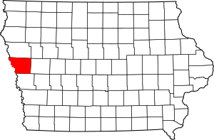
Monona County is a county located in the state of Iowa in the United States. It's like a special region within the state. In 2020, about 8,751 people lived here. The main town, or county seat, where the county government is located, is Onawa.
Contents
A Look Back: Monona County's History
The area where Monona County is today has an interesting past. In 1804, two famous explorers named Meriwether Lewis and William Clark stopped here during their big trip across the newly bought Louisiana Purchase. This journey was called the Lewis and Clark Expedition. Today, you can visit Lewis and Clark State Park to remember their visit.
Monona County was officially created in 1851. Its name might come from an old Native American word that means "beautiful valley."
The county was fully set up in the spring of 1854. Before that, it was part of other counties like Benton County and Harrison County.
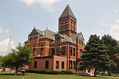
When the town of Ashton (which was first called Bloomfield) became the county seat in 1854, the first courthouse was a simple log house. But Ashton was the county seat for only four years. In 1858, the main town was changed to Onawa, and the first Monona County Courthouse there was finished that same year.
Exploring Monona County's Geography
Monona County covers a total area of about 699 square miles. Most of this (694 square miles) is land, and a small part (about 4.9 square miles) is water.
Main Roads You Can Drive On
These are the important highways that go through Monona County:
Neighboring Counties
Monona County shares its borders with these other counties:
- Woodbury County (to the north)
- Crawford County (to the east)
- Harrison County (to the south)
- Burt County, Nebraska (to the southwest)
- Thurston County, Nebraska (to the west)
Who Lives Here? Monona County's Population
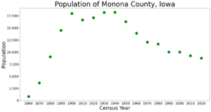
| Historical population | |||
|---|---|---|---|
| Census | Pop. | %± | |
| 1860 | 832 | — | |
| 1870 | 3,654 | 339.2% | |
| 1880 | 9,055 | 147.8% | |
| 1890 | 14,515 | 60.3% | |
| 1900 | 17,980 | 23.9% | |
| 1910 | 16,633 | −7.5% | |
| 1920 | 17,125 | 3.0% | |
| 1930 | 18,213 | 6.4% | |
| 1940 | 18,238 | 0.1% | |
| 1950 | 16,303 | −10.6% | |
| 1960 | 13,916 | −14.6% | |
| 1970 | 12,069 | −13.3% | |
| 1980 | 11,692 | −3.1% | |
| 1990 | 10,034 | −14.2% | |
| 2000 | 10,020 | −0.1% | |
| 2010 | 9,243 | −7.8% | |
| 2020 | 8,751 | −5.3% | |
| 2023 (est.) | 8,493 | −8.1% | |
| U.S. Decennial Census 1790-1960 1900-1990 1990-2000 2010-2018 |
|||
Every ten years, the United States counts its population in a "census." This helps us understand how many people live in different areas.
The 2020 Census Results
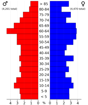
The 2020 census counted 8,751 people living in Monona County. This means there were about 12.5 people for every square mile. Most people (about 96%) reported being of one race. About 90% were non-Hispanic White.

The 2010 Census Results
In the 2010 census, Monona County had a population of 9,243 people. There were about 13.3 people per square mile back then.
Towns and Areas in Monona County
Monona County has several towns and smaller areas.
Cities and Towns
Smaller Unincorporated Communities
- Ticonic
Townships
Counties are often divided into smaller areas called townships. Here are the townships in Monona County:
- Ashton
- Belvidere
- Center
- Cooper
- Fairview
- Franklin
- Grant
- Jordan
- Kennebec
- Lake
- Lincoln
- Maple
- St. Clair
- Sherman
- Sioux
- Soldier
- Spring Valley
- West Fork
- Willow
How Towns Rank by Population
This table shows the towns in Monona County from largest to smallest, based on the 2020 census.
† This symbol means it's the county seat, the main town.
| Rank | City/Town/etc. | Population (2020 Census) |
|---|---|---|
| 1 | † Onawa | 2,906 |
| 2 | Mapleton | 1,165 |
| 3 | Whiting | 745 |
| 4 | Ute | 338 |
| 5 | Blencoe | 233 |
| 6 | Moorhead | 199 |
| 7 | Soldier | 184 |
| 8 | Castana | 107 |
| 9 | Turin | 72 |
| 10 | Rodney | 45 |
See also
 In Spanish: Condado de Monona para niños
 | Jewel Prestage |
 | Ella Baker |
 | Fannie Lou Hamer |


