Onawa, Iowa facts for kids
Quick facts for kids
Onawa, Iowa
|
|
|---|---|
 |
|

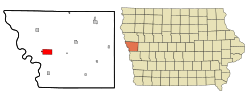
Location of Onawa, Iowa
|
|
| Country | United States |
| State | Iowa |
| County | Monona |
| Area | |
| • Total | 5.27 sq mi (13.64 km2) |
| • Land | 5.27 sq mi (13.64 km2) |
| • Water | 0.00 sq mi (0.00 km2) |
| Elevation | 1,050 ft (320 m) |
| Population
(2020)
|
|
| • Total | 2,906 |
| • Density | 551.63/sq mi (212.98/km2) |
| Time zone | UTC-6 (Central (CST)) |
| • Summer (DST) | UTC-5 (CDT) |
| ZIP code |
51040
|
| Area code(s) | 712 |
| FIPS code | 19-59115 |
| GNIS feature ID | 0459865 |
Onawa is a city in Monona County, Iowa, United States. It is also the county seat, which means it is the main town where the county government is located. In 2020, about 2,906 people lived here. Onawa is the biggest town on the Iowa side of the Missouri River between Council Bluffs and Sioux City.
Contents
History of Onawa
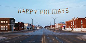
Onawa got its name from a character in a famous poem called The Song of Hiawatha by Henry Wadsworth Longfellow. The city was first planned out in 1857. This process, called platting, means marking out streets and building lots. The railway reached Onawa in 1867, helping the town grow. Onawa is famous for having the widest main street in the entire continental United States!
Between 1944 and 1946, during World War II, Onawa was home to a special camp. This camp housed captured German soldiers. Historical records show that there were never more than 50 soldiers at this camp. A much larger camp for German soldiers was located near Algona, which held up to 5,400 people.
Onawa's Geography and Nature
Onawa is located in western Iowa, a unique area known as the Loess Hills. This region has special hills made of wind-blown soil.
The city covers about 5.19 square miles (13.44 square kilometers) of land. There is no water area within the city limits.
You can find several beautiful natural areas close to Onawa, including:
- Lewis & Clark State Park
- Preparation Canyon State Park
- The Loess Hills State Forest
These places are great for exploring nature and enjoying the outdoors.
Population and People of Onawa
| Historical populations | ||
|---|---|---|
| Year | Pop. | ±% |
| 1870 | 478 | — |
| 1880 | 882 | +84.5% |
| 1890 | 1,358 | +54.0% |
| 1900 | 1,933 | +42.3% |
| 1910 | 2,026 | +4.8% |
| 1920 | 2,256 | +11.4% |
| 1930 | 2,538 | +12.5% |
| 1940 | 3,438 | +35.5% |
| 1950 | 3,498 | +1.7% |
| 1960 | 3,176 | −9.2% |
| 1970 | 3,154 | −0.7% |
| 1980 | 3,283 | +4.1% |
| 1990 | 2,936 | −10.6% |
| 2000 | 3,091 | +5.3% |
| 2010 | 2,998 | −3.0% |
| 2020 | 2,906 | −3.1% |
| Source: and Iowa Data Center Source: |
||
Onawa's Population in 2020
In 2020, the city of Onawa had 2,906 people living there. There were 1,290 households, which are groups of people living together. The city had about 551.6 people per square mile.
Most of the people in Onawa (about 90.2%) were White. About 3.5% were Native American, and smaller percentages were Black, Asian, or from other backgrounds. About 1.9% of the population identified as Hispanic or Latino.
The average age in Onawa was 42 years old. About 25.3% of the residents were under 20 years old. Also, 23.2% of the people were 65 years old or older. The population was almost evenly split between males (47.1%) and females (52.9%).
Onawa's Population in 2010
According to the 2010 Census, Onawa had 2,998 people. There were 1,345 households in the city. The population density was about 577.6 people per square mile.
About 95.4% of the people were White. Other groups included Native American, Black, and Asian residents. About 1.2% of the population was Hispanic or Latino.
The average age in Onawa in 2010 was 44.8 years. About 23.2% of the residents were under 18 years old. Also, 24% of the people were 65 years old or older. The city's population was 47.5% male and 52.5% female.
Education in Onawa
Public schools in Onawa are managed by the West Monona Community School District. This district provides education for students living in the community.
Culture and Fun Facts about Onawa

Did you know that the famous Eskimo Pie was invented in Onawa? In 1920, Chris Nelson, who owned an ice cream shop in Onawa, created this popular treat.
Notable People from Onawa
Many interesting people have connections to Onawa:
- E. Wight Bakke, an educator
- John Stevens Berry, an attorney and author
- Charles "Buster" Brown, a Major League Baseball pitcher
- Ken Carlson, a politician
- Kristine Jepson, an opera singer
- Neil E. McNeil (Oklahoma), an attorney and justice
- Wayne M. Ropes, a businessman and Iowa Secretary of State
See also
 In Spanish: Onawa (Iowa) para niños
 | Mary Eliza Mahoney |
 | Susie King Taylor |
 | Ida Gray |
 | Eliza Ann Grier |

