Castana, Iowa facts for kids
Quick facts for kids
Castana, Iowa
|
|
|---|---|
 |
|

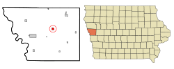
Location of Castana, Iowa
|
|
| Country | |
| State | |
| County | Monona |
| Area | |
| • Total | 0.91 sq mi (2.35 km2) |
| • Land | 0.91 sq mi (2.35 km2) |
| • Water | 0.00 sq mi (0.00 km2) |
| Elevation | 1,148 ft (350 m) |
| Population
(2020)
|
|
| • Total | 107 |
| • Density | 117.97/sq mi (45.53/km2) |
| Time zone | UTC-6 (Central (CST)) |
| • Summer (DST) | UTC-5 (CDT) |
| ZIP code |
51010
|
| Area code(s) | 712 |
| FIPS code | 19-11530 |
| GNIS feature ID | 0455207 |
| Website | City website |
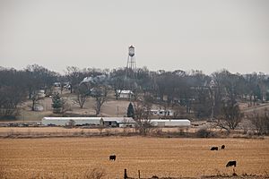
Castana is a small city located in Monona County, Iowa, in the United States. It's a quiet place with a population of 107 people, according to the 2020 census. Castana is known for its peaceful rural setting and its connection to agricultural research.
Contents
Discovering Castana's Past
Castana has a history that goes back to the 1800s. A post office first opened here in 1865, helping people send and receive mail.
How Castana Began
The city was officially planned and laid out in 1886 by the railroad. This process is called "platting," which means creating a map of land divided into lots. An early settler chose the name "Castana" because they thought it was a Latin word for "chestnuts."
Exploring Castana's Location
Castana is located in western Iowa. Its exact coordinates are 42°4′21″N 95°54′30″W / 42.07250°N 95.90833°W. This means it's at 42.072518 degrees north latitude and 95.908266 degrees west longitude.
Size and Nearby Cities
The city covers a total area of about 0.91 square miles (2.35 square kilometers), and all of it is land. Castana is about 10 miles (16 km) from Onawa and 39 miles (63 km) from Sioux City.
Learning and Research in Castana
Just outside Castana, you'll find the Western Iowa Experimental Farm. This farm is part of Iowa State University. It's a special place where scientists and researchers study different aspects of farming.
What They Research
At the experimental farm, they conduct important research on:
- Beef cattle: How to raise healthy cattle for meat.
- Swine: Studies related to pigs.
- Forage: Plants that are grown as food for farm animals.
- Fertilizer effects: How different fertilizers impact crops like soybeans and corn.
This research helps farmers grow better crops and raise healthier animals.
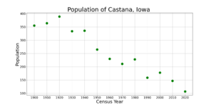
Castana's Population Over Time
| Historical populations | ||
|---|---|---|
| Year | Pop. | ±% |
| 1900 | 355 | — |
| 1910 | 364 | +2.5% |
| 1920 | 389 | +6.9% |
| 1930 | 334 | −14.1% |
| 1940 | 336 | +0.6% |
| 1950 | 265 | −21.1% |
| 1960 | 230 | −13.2% |
| 1970 | 211 | −8.3% |
| 1980 | 228 | +8.1% |
| 1990 | 159 | −30.3% |
| 2000 | 178 | +11.9% |
| 2010 | 147 | −17.4% |
| 2020 | 107 | −27.2% |
| Source: and Iowa Data Center Source: |
||
The population of Castana has changed quite a bit over the years. In 1900, there were 355 people living there. The population reached its highest point in 1920 with 389 residents. Since then, the number of people living in Castana has generally decreased.
Recent Population Counts
- 2010 Census: In 2010, Castana had 147 people. Most residents were White.
- 2020 Census: By 2020, the population had decreased to 107 people. The city had 51 households. About 92.5% of the residents were White.
The median age in Castana in 2020 was 49.5 years. This means half the people were younger than 49.5 and half were older. About 22.4% of the residents were under 20 years old.
Education in Castana
Students in Castana attend schools within the Maple Valley–Anthon–Oto Community School District.
History of Schools in Castana
Castana once had its own school district called the Castana Consolidated Independent School District.
- The first classrooms were in a building built in 1888.
- A larger, three-story school building, the Castana Normal School, opened in 1897.
- In 1920, the school district bought a house for teachers, which also held classes for some grades.
New School Buildings and Mergers
- The last school building in Castana, the Castana Consolidated School, was built in 1935 and 1936. It opened for students on September 7, 1936.
- In 1954, this school was renamed the Castana Community School.
- Starting in 1962, high school students from Castana began attending schools in nearby Mapleton and Onawa.
- In 1968, the Castana district joined with the Maple Valley district.
- Later, on July 1, 2012, the Maple Valley district combined with the Anthon–Oto Community School District to form the current Maple Valley–Anthon–Oto district.
Famous People from Castana
Castana has been home to a few notable individuals:
- Richard D. Kisling: He served as the third Chief Master Sergeant of the Air Force, a very important leadership role in the U.S. Air Force.
- Dale Swanson: A racing driver who competed in various races.
See also
 In Spanish: Castana (Iowa) para niños
 | Chris Smalls |
 | Fred Hampton |
 | Ralph Abernathy |


