Cuming County, Nebraska facts for kids
Quick facts for kids
Cuming County
|
||
|---|---|---|

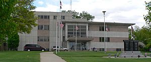
Cuming County Courthouse in West Point
|
||
|
||

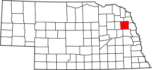
Location within the U.S. state of Nebraska
|
||
 Nebraska's location within the U.S. |
||
| Country | ||
| State | ||
| Founded | 1855 (authorized) 1857 (organized) |
|
| Named for | Thomas B. Cuming | |
| Seat | West Point | |
| Largest city | West Point | |
| Area | ||
| • Total | 575 sq mi (1,490 km2) | |
| • Land | 571 sq mi (1,480 km2) | |
| • Water | 4.0 sq mi (10 km2) 0.7%% | |
| Population
(2020)
|
||
| • Total | 9,013 |
|
| • Density | 16/sq mi (6/km2) | |
| Time zone | UTC−6 (Central) | |
| • Summer (DST) | UTC−5 (CDT) | |
| Congressional district | 1st | |
Cuming County is a county located in the state of Nebraska in the United States. In 2020, about 9,013 people lived here. The main town and county seat is West Point. When Nebraska started its license plate system in 1922, Cuming County was given the number 24. This was because it had the 24th highest number of registered vehicles in the state.
Contents
History of Cuming County
Cuming County was officially created in 1855. It started operating as a county in 1857. The county was named after Thomas B. Cuming. He was the first secretary of the Nebraska Territory. He also served as the Acting Governor two times between 1854 and 1858. The building where the county government works, called the courthouse, was built in the 1950s.
Geography of Cuming County
Cuming County covers an area of about 575 square miles. Most of this area, about 571 square miles, is land. The remaining 4 square miles (which is 0.7%) is water.
Main Roads in Cuming County
These are the most important highways that run through Cuming County:
Neighboring Counties
Cuming County shares its borders with several other counties:
- Thurston County – to the northeast
- Burt County – to the east
- Dodge County – to the south
- Colfax County – to the southwest
- Stanton County – to the west
- Wayne County – to the northwest
Population of Cuming County
| Historical population | |||
|---|---|---|---|
| Census | Pop. | %± | |
| 1860 | 67 | — | |
| 1870 | 2,964 | 4,323.9% | |
| 1880 | 5,569 | 87.9% | |
| 1890 | 12,265 | 120.2% | |
| 1900 | 14,584 | 18.9% | |
| 1910 | 13,782 | −5.5% | |
| 1920 | 13,769 | −0.1% | |
| 1930 | 14,327 | 4.1% | |
| 1940 | 13,562 | −5.3% | |
| 1950 | 12,994 | −4.2% | |
| 1960 | 12,435 | −4.3% | |
| 1970 | 12,034 | −3.2% | |
| 1980 | 11,664 | −3.1% | |
| 1990 | 10,117 | −13.3% | |
| 2000 | 10,203 | 0.9% | |
| 2010 | 9,139 | −10.4% | |
| 2020 | 9,013 | −1.4% | |
| US Decennial Census 1790-1960 1900-1990 1990-2000 2010 |
|||
In 2000, there were 10,203 people living in Cuming County. There were about 3,945 households. A household is a group of people living together. The average household had about 2.5 people. Many families (about 61.7%) were married couples living together.
About 27.2% of the population was under 18 years old. About 20.2% of the people were 65 years old or older. The average age in the county was 39 years.
Towns and Villages in Cuming County
Cuming County has several communities, including cities and smaller villages.
Cities
- West Point (This is the county seat, where the main county government offices are.)
- Wisner
Villages
Unincorporated Community
- Aloys (This is a small community that is not officially part of a city or village.)
Townships
Townships are smaller areas within the county, often used for local government.
- Bancroft
- Beemer
- Bismark
- Blaine
- Cleveland
- Cuming
- Elkhorn
- Garfield
- Grant
- Lincoln
- Logan
- Monterey
- Neligh
- St. Charles
- Sherman
- Wisner
Education in Cuming County
Here are some of the school districts that serve students in Cuming County:
- Bancroft-Rosalie Community Schools
- Howells-Dodge Consolidated Schools
- Logan View Public Schools
- Lyons-Decatur Northeast Schools
- Oakland Craig Public Schools
- Pender Public Schools
- Scribner-Snyder Community Schools
- West Point Public Schools
- Wisner-Pilger Public Schools
See also
 In Spanish: Condado de Cuming para niños
 | Shirley Ann Jackson |
 | Garett Morgan |
 | J. Ernest Wilkins Jr. |
 | Elijah McCoy |


