West Point, Nebraska facts for kids
Quick facts for kids
West Point, Nebraska
|
||
|---|---|---|

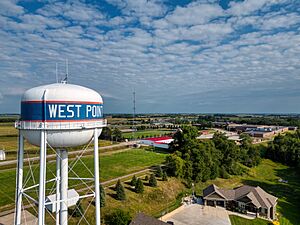
Aerial view of water tower in West Point, NE
|
||
|
||

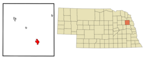
Location of West Point, Nebraska
|
||
| Country | United States | |
| State | Nebraska | |
| County | Cuming | |
| Area | ||
| • Total | 2.85 sq mi (7.39 km2) | |
| • Land | 2.84 sq mi (7.35 km2) | |
| • Water | 0.01 sq mi (0.03 km2) | |
| Elevation | 1,404 ft (428 m) | |
| Population
(2020)
|
||
| • Total | 3,500 | |
| • Density | 1,232.39/sq mi (475.88/km2) | |
| Time zone | UTC-6 (Central (CST)) | |
| • Summer (DST) | UTC-5 (CDT) | |
| ZIP code |
68788
|
|
| Area code(s) | 402 | |
| FIPS code | 31-52575 | |
| GNIS feature ID | 838328 | |
West Point is a city located in Cuming County, Nebraska, in the United States. It is also the main town, or county seat, of Cuming County. In 2020, about 3,504 people lived there.
Contents
History of West Point
West Point was started in the spring of 1857. Business people from Omaha created a group to find good places for new towns in the Elkhorn Valley. Three brothers from Pennsylvania, Uriah, John, and Andrew Bruner, along with William Sexauer, chose the current spot. It was on a bend in a river.
They first named the town New Philadelphia. But soon, the name was changed to West Point. This was because it was the westernmost settlement in that valley at the time.
Becoming the County Seat
West Point became the county seat of Cuming County on October 12, 1858. It won an election against another community called DeWitt. West Point received 12 votes, while DeWitt received 7 votes.
In the spring of 1859, over 4,000 Pawnee Native Americans came to the Elkhorn Valley for a hunting trip. They were not happy to find white settlers there. They burned some homes and killed farm animals. This event was called the "Pawnee War," but it ended without a big fight near Battle Creek.
Growth and the Railroad
West Point grew slowly at first. However, when the railroad arrived in 1870, the town quickly grew. Its population boomed to over 700 people.
By the mid-1970s, the future of the railroad in West Point became uncertain. The Chicago and North Western Transportation Company's tracks were not being used as much for carrying goods. In the spring of 1982, floods from the Elkhorn River damaged parts of the track.
Because there was less freight and the tracks were damaged, the railroad company asked to stop using the line. They were allowed to do so. There were plans to bring back train service with a new company called the Fremont and Elkhorn Valley Railroad. They bought the old tracks. The idea was to bring tourists to West Point and maybe even carry goods again. However, the costs to fix the tracks were too high. So, the tracks were removed in 1988.
Water Safety Concerns
On August 26, 2019, the United States Department of Health and Human Services (DHHS) announced a problem with the city's water. After a year of complaints from residents, the DHHS said the water was not safe to drink. The amount of manganese in the water was too high for babies, exceeding the safe level by more than 700 micrograms per mL.
Geography and Climate
West Point is located on the eastern bank of the Elkhorn River. The city covers a total area of about 2.73 square miles (7.07 square kilometers). Most of this area, about 2.72 square miles (7.04 square kilometers), is land. A very small part, about 0.01 square miles (0.03 square kilometers), is water.
Local Climate
West Point experiences a climate with warm summers and cold winters. Here is a summary of the weather conditions:
| Climate data for West Point, Nebraska (1991–2020, extremes 1892–present) | |||||||||||||
|---|---|---|---|---|---|---|---|---|---|---|---|---|---|
| Month | Jan | Feb | Mar | Apr | May | Jun | Jul | Aug | Sep | Oct | Nov | Dec | Year |
| Record high °F (°C) | 69 (21) |
75 (24) |
92 (33) |
100 (38) |
105 (41) |
108 (42) |
113 (45) |
111 (44) |
105 (41) |
96 (36) |
84 (29) |
75 (24) |
113 (45) |
| Mean maximum °F (°C) | 53.8 (12.1) |
59.2 (15.1) |
73.7 (23.2) |
83.3 (28.5) |
90.4 (32.4) |
94.7 (34.8) |
95.4 (35.2) |
93.6 (34.2) |
90.6 (32.6) |
85.0 (29.4) |
70.5 (21.4) |
56.3 (13.5) |
97.2 (36.2) |
| Mean daily maximum °F (°C) | 30.4 (−0.9) |
35.1 (1.7) |
47.7 (8.7) |
60.3 (15.7) |
71.3 (21.8) |
81.3 (27.4) |
85.0 (29.4) |
82.7 (28.2) |
76.4 (24.7) |
63.5 (17.5) |
47.7 (8.7) |
34.6 (1.4) |
59.7 (15.4) |
| Daily mean °F (°C) | 20.5 (−6.4) |
24.8 (−4.0) |
36.7 (2.6) |
48.5 (9.2) |
60.3 (15.7) |
70.8 (21.6) |
74.8 (23.8) |
72.3 (22.4) |
64.2 (17.9) |
51.0 (10.6) |
36.8 (2.7) |
25.1 (−3.8) |
48.8 (9.3) |
| Mean daily minimum °F (°C) | 10.7 (−11.8) |
14.5 (−9.7) |
25.6 (−3.6) |
36.7 (2.6) |
49.3 (9.6) |
60.3 (15.7) |
64.5 (18.1) |
61.8 (16.6) |
52.0 (11.1) |
38.6 (3.7) |
25.9 (−3.4) |
15.6 (−9.1) |
38.0 (3.3) |
| Mean minimum °F (°C) | −11.6 (−24.2) |
−5.8 (−21.0) |
4.8 (−15.1) |
21.3 (−5.9) |
34.0 (1.1) |
47.0 (8.3) |
52.0 (11.1) |
50.0 (10.0) |
36.4 (2.4) |
22.5 (−5.3) |
9.4 (−12.6) |
−4.6 (−20.3) |
−15.2 (−26.2) |
| Record low °F (°C) | −38 (−39) |
−33 (−36) |
−22 (−30) |
3 (−16) |
20 (−7) |
36 (2) |
41 (5) |
39 (4) |
22 (−6) |
5 (−15) |
−14 (−26) |
−27 (−33) |
−38 (−39) |
| Average precipitation inches (mm) | 0.69 (18) |
0.86 (22) |
1.66 (42) |
3.41 (87) |
4.20 (107) |
5.23 (133) |
3.31 (84) |
3.91 (99) |
3.02 (77) |
2.14 (54) |
1.34 (34) |
1.04 (26) |
30.81 (783) |
| Average snowfall inches (cm) | 5.9 (15) |
7.6 (19) |
4.1 (10) |
1.8 (4.6) |
0.1 (0.25) |
0.0 (0.0) |
0.0 (0.0) |
0.0 (0.0) |
0.0 (0.0) |
0.5 (1.3) |
2.6 (6.6) |
6.3 (16) |
28.9 (73) |
| Average precipitation days (≥ 0.01 in) | 6.1 | 6.0 | 7.6 | 10.2 | 12.6 | 11.3 | 9.5 | 9.0 | 8.4 | 7.5 | 5.6 | 6.0 | 99.8 |
| Average snowy days (≥ 0.1 in) | 4.6 | 4.2 | 2.5 | 0.8 | 0.0 | 0.0 | 0.0 | 0.0 | 0.0 | 0.3 | 1.6 | 4.1 | 18.1 |
| Source: NOAA | |||||||||||||
Population and People
The population of West Point has changed over the years. Here is a look at how many people have lived in the city during different census counts:
| Historical population | |||
|---|---|---|---|
| Census | Pop. | %± | |
| 1860 | 14 | — | |
| 1870 | 520 | 3,614.3% | |
| 1880 | 1,009 | 94.0% | |
| 1890 | 1,842 | 82.6% | |
| 1900 | 1,890 | 2.6% | |
| 1910 | 1,776 | −6.0% | |
| 1920 | 2,002 | 12.7% | |
| 1930 | 2,225 | 11.1% | |
| 1940 | 2,510 | 12.8% | |
| 1950 | 2,658 | 5.9% | |
| 1960 | 2,921 | 9.9% | |
| 1970 | 3,385 | 15.9% | |
| 1980 | 3,609 | 6.6% | |
| 1990 | 3,250 | −9.9% | |
| 2000 | 3,660 | 12.6% | |
| 2010 | 3,364 | −8.1% | |
| 2020 | 3,504 | 4.2% | |
| 2021 (est.) | 3,473 | 3.2% | |
| U.S. Decennial Census | |||
2010 Census Information
In 2010, the city of West Point had 3,364 people living there. There were 1,432 households, which are groups of people living together in a home. Out of these, 899 were families.
The city had about 1,237 people per square mile (478 people per square kilometer). There were 1,580 housing units, like houses or apartments.
Most of the people in West Point were White (87.7%). A small number were African American (0.3%), Native American (0.4%), or Asian (0.3%). About 10.3% of the people were from other racial backgrounds. Also, 16.8% of the population identified as Hispanic or Latino.
About 27.4% of households had children under 18 living with them. More than half (52.0%) were married couples living together. Some households had a female head without a husband (7.3%), or a male head without a wife (3.5%). About 37.2% were non-family households, meaning people living alone or with roommates.
About 34.1% of all households were made up of just one person. And 19.4% of households had someone aged 65 or older living alone. The average number of people in a household was 2.31, and the average family size was 2.97.
The average age of people in the city was 43.2 years. About 25.5% of residents were under 18. About 22.6% were 65 years or older. The population was almost evenly split between males (48.1%) and females (51.9%).
Education in West Point
The schools in West Point are part of the West Point Public Schools district.
Notable People from West Point
Many interesting people have connections to West Point:
- Lawrence Bruner was an internationally known expert on insects (an entomologist) from the University of Nebraska.
- Richard C. Hunter served as a U.S. Senator for Nebraska.
- Eldon Johnson was a state lawmaker in Oregon.
- Martin E. Marty is a well-known scholar who studies religion.
- Karl H. Timmermann was an American officer who led the first attack on the Ludendorff Bridge at Remagen during World War II. He was the first American officer to cross the River Rhine into Germany during the war.
- Edward K. Valentine was a former U.S. Representative and also served as the Sergeant at Arms of the U.S. Senate.
- Tim Walz is the current Governor of Minnesota. He was also a U.S. Representative and is the 2024 Democratic candidate for Vice President of the United States.
See also
 In Spanish: West Point (Nebraska) para niños
 | Valerie Thomas |
 | Frederick McKinley Jones |
 | George Edward Alcorn Jr. |
 | Thomas Mensah |


