Mead, Nebraska facts for kids
Quick facts for kids
Mead, Nebraska
|
|
|---|---|
|
Village
|
|

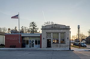
Post office, bank, and water tower in Mead, March 2017
|
|

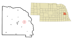
Location of Mead, Nebraska
|
|
| Country | United States |
| State | Nebraska |
| County | Saunders |
| Township | Marietta |
| Area | |
| • Total | 0.62 sq mi (1.60 km2) |
| • Land | 0.61 sq mi (1.58 km2) |
| • Water | 0.01 sq mi (0.03 km2) |
| Elevation | 1,207 ft (368 m) |
| Population
(2020)
|
|
| • Total | 617 |
| • Density | 1,013.14/sq mi (391.37/km2) |
| Time zone | UTC-6 (Central (CST)) |
| • Summer (DST) | UTC-5 (CDT) |
| ZIP code |
68041
|
| Area code(s) | 402 |
| FIPS code | 31-31395 |
| GNIS feature ID | 2399299 |
| Website | www.meadnebraska.net |
Mead is a small village located in Saunders County, Nebraska, in the United States. In 2020, the village had a population of 617 people. It is a quiet community with a history connected to the railroad and local industries.
Contents
History of Mead
Mead was first settled mainly by people from Sweden. It was originally called Saunders. The village was officially planned out in 1877 when the railroad tracks reached that area. In 1880, its name was changed to Mead. This new name was likely chosen to honor an official from the Union Pacific railroad company.
Ethanol Plant Operations
An ethanol production plant, called E3 Biofuels, started operating in Mead in 2007. This plant used a special "closed loop" system to make ethanol. However, it stopped operating later that same year. Another company, AltEn, later reopened the plant. This plant also closed down in February 2021. The land where the plant was located has some chemical contamination.
Population and People in Mead
Understanding the people who live in a place is called demographics. Mead's population has changed over many years.
| Historical population | |||
|---|---|---|---|
| Census | Pop. | %± | |
| 1890 | 324 | — | |
| 1900 | 330 | 1.9% | |
| 1910 | 330 | 0.0% | |
| 1920 | 329 | −0.3% | |
| 1930 | 310 | −5.8% | |
| 1940 | 260 | −16.1% | |
| 1950 | 388 | 49.2% | |
| 1960 | 428 | 10.3% | |
| 1970 | 488 | 14.0% | |
| 1980 | 506 | 3.7% | |
| 1990 | 513 | 1.4% | |
| 2000 | 564 | 9.9% | |
| 2010 | 569 | 0.9% | |
| 2020 | 617 | 8.4% | |
| U.S. Decennial Census | |||
Mead's Population in 2010
According to the census from 2010, there were 569 people living in Mead. These people lived in 215 households, and 159 of these were families. The village had about 933 people per square mile. There were 235 homes in total.
Most of the people in Mead (98.1%) were White. A small number were Native American (0.2%) or Asian (0.4%). About 1.1% were from other racial backgrounds, and 0.4% were from two or more races. About 3.0% of the population identified as Hispanic or Latino.
Many households (40.9%) had children under 18 living with them. More than half (55.3%) were married couples. About 21.4% of all households had only one person living there. The average household had 2.65 people, and the average family had 3.04 people.
The average age of people in the village was 37.1 years old. About 28.8% of residents were under 18. About 13.2% were 65 years old or older. The population was almost evenly split between males (49.6%) and females (50.4%).
Geography and Climate
Mead is located in Nebraska. The United States Census Bureau states that the village covers a total area of about 0.62 square miles (1.60 square kilometers). Most of this area, about 0.61 square miles (1.58 square kilometers), is land. A very small part, about 0.01 square miles (0.03 square kilometers), is water.
Mead's Weather
The climate in Mead, Nebraska, experiences all four seasons. Summers are generally warm, and winters are cold. The area gets a good amount of rain throughout the year, especially in late spring and early summer. Snowfall is common during the winter months.
| Climate data for Mead 6S, Nebraska (1991–2020, extremes 1968–present) | |||||||||||||
|---|---|---|---|---|---|---|---|---|---|---|---|---|---|
| Month | Jan | Feb | Mar | Apr | May | Jun | Jul | Aug | Sep | Oct | Nov | Dec | Year |
| Record high °F (°C) | 71 (22) |
78 (26) |
90 (32) |
97 (36) |
99 (37) |
108 (42) |
107 (42) |
105 (41) |
107 (42) |
95 (35) |
86 (30) |
69 (21) |
108 (42) |
| Mean maximum °F (°C) | 56.4 (13.6) |
62.4 (16.9) |
76.1 (24.5) |
85.4 (29.7) |
90.8 (32.7) |
94.9 (34.9) |
97.4 (36.3) |
96.1 (35.6) |
93.0 (33.9) |
86.5 (30.3) |
72.7 (22.6) |
59.4 (15.2) |
99.1 (37.3) |
| Mean daily maximum °F (°C) | 32.7 (0.4) |
37.4 (3.0) |
50.5 (10.3) |
62.7 (17.1) |
72.6 (22.6) |
82.8 (28.2) |
86.6 (30.3) |
84.5 (29.2) |
78.4 (25.8) |
65.4 (18.6) |
50.0 (10.0) |
37.0 (2.8) |
61.7 (16.5) |
| Daily mean °F (°C) | 22.4 (−5.3) |
26.6 (−3.0) |
38.6 (3.7) |
49.9 (9.9) |
60.9 (16.1) |
71.3 (21.8) |
75.1 (23.9) |
72.9 (22.7) |
65.1 (18.4) |
52.3 (11.3) |
38.2 (3.4) |
27.0 (−2.8) |
50.0 (10.0) |
| Mean daily minimum °F (°C) | 12.0 (−11.1) |
15.9 (−8.9) |
26.6 (−3.0) |
37.2 (2.9) |
49.3 (9.6) |
59.9 (15.5) |
63.7 (17.6) |
61.3 (16.3) |
51.8 (11.0) |
39.2 (4.0) |
26.3 (−3.2) |
16.9 (−8.4) |
38.3 (3.5) |
| Mean minimum °F (°C) | −8.5 (−22.5) |
−3.3 (−19.6) |
6.9 (−13.9) |
22.6 (−5.2) |
35.7 (2.1) |
48.6 (9.2) |
53.6 (12.0) |
51.1 (10.6) |
37.2 (2.9) |
23.1 (−4.9) |
9.9 (−12.3) |
−2.9 (−19.4) |
−12.4 (−24.7) |
| Record low °F (°C) | −37 (−38) |
−29 (−34) |
−18 (−28) |
3 (−16) |
23 (−5) |
35 (2) |
39 (4) |
38 (3) |
26 (−3) |
9 (−13) |
−7 (−22) |
−27 (−33) |
−37 (−38) |
| Average precipitation inches (mm) | 0.62 (16) |
0.78 (20) |
1.53 (39) |
2.92 (74) |
4.72 (120) |
4.90 (124) |
3.08 (78) |
3.77 (96) |
3.15 (80) |
2.18 (55) |
1.33 (34) |
1.12 (28) |
30.10 (765) |
| Average snowfall inches (cm) | 4.7 (12) |
6.0 (15) |
2.6 (6.6) |
0.8 (2.0) |
0.1 (0.25) |
0.0 (0.0) |
0.0 (0.0) |
0.0 (0.0) |
0.0 (0.0) |
0.5 (1.3) |
1.2 (3.0) |
4.4 (11) |
20.3 (52) |
| Average precipitation days (≥ 0.01 in) | 4.4 | 4.9 | 6.5 | 9.1 | 11.8 | 9.6 | 8.4 | 8.9 | 6.9 | 6.6 | 4.7 | 4.9 | 86.7 |
| Average snowy days (≥ 0.1 in) | 2.9 | 2.9 | 1.4 | 0.2 | 0.0 | 0.0 | 0.0 | 0.0 | 0.0 | 0.2 | 1.0 | 2.6 | 11.2 |
| Source: NOAA | |||||||||||||
See also
 In Spanish: Mead (Nebraska) para niños
 | Mary Eliza Mahoney |
 | Susie King Taylor |
 | Ida Gray |
 | Eliza Ann Grier |


