Sarpy County, Nebraska facts for kids
Quick facts for kids
Sarpy County
|
|
|---|---|

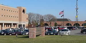
Sarpy County Courthouse in Papillion
|
|

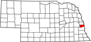
Location within the U.S. state of Nebraska
|
|
 Nebraska's location within the U.S. |
|
| Country | |
| State | |
| Founded | February 1, 1857 |
| Named for | Peter A. Sarpy |
| Seat | Papillion |
| Largest city | Bellevue |
| Area | |
| • Total | 248 sq mi (640 km2) |
| • Land | 239 sq mi (620 km2) |
| • Water | 8.5 sq mi (22 km2) 3.4%% |
| Population
(2020)
|
|
| • Total | 190,604 |
| • Estimate
(2022)
|
196,553 |
| • Density | 768.6/sq mi (296.7/km2) |
| Time zone | UTC−6 (Central) |
| • Summer (DST) | UTC−5 (CDT) |
| Congressional districts | 1st, 2nd |
Sarpy County is a county located in the state of Nebraska in the United States. In 2020, about 190,604 people lived here. This makes it the third-most populated county in Nebraska. The main city and county seat is Papillion.
Sarpy County is part of the larger Omaha-Council Bluffs region, which includes parts of Nebraska and Iowa.
Contents
History of Sarpy County
This area was once the home of the Omaha people. In 1803, the United States bought a huge amount of land, including this area, in what was called the Louisiana Purchase. Soon after, in 1805, the famous explorers Lewis and Clark explored the region.
Over time, different groups of European-Americans came to settle here. First came fur traders, then adventurers, farmers, and business people. They all used the Missouri River for travel and water. Sarpy County played a big part in the early settlement and growth of Nebraska.
The county is named after Colonel Peter Sarpy. He was an early fur trader who had a trading post near Bellevue in the 1840s. He passed away in Plattsmouth in 1865.
Sarpy County was originally part of Douglas County. But on February 1, 1857, the government decided to make the southern half of Douglas County its own separate county, and that's how Sarpy County was created.
In the 1800s, the Omaha people were moved to a special area called a reservation. This meant they lost most of their land, which was then opened up for new settlers from the United States and other countries, mostly from Europe.
Fort Crook and Offutt Air Force Base
Fort Crook was a U.S. Army base built in the 1890s, just south of Bellevue. In the 1920s, it added an airfield called Offutt Field. During World War II, a factory there, the Glenn L. Martin Bomber Plant, built over two thousand airplanes. This included famous B-29 bombers like the Enola Gay and Bockscar.
Later, this base became Offutt Air Force Base. It was the main headquarters for the Strategic Air Command (SAC) during the Cold War. Today, it is still an important base, home to the U.S. Strategic Command.
Geography of Sarpy County
Sarpy County is bordered by the Missouri River to the east and the Platte River to the south and west. The land here has gentle rolling hills and small streams that flow into these rivers.
The county covers a total area of about 248 square miles (642 square kilometers). Most of this is land (239 square miles or 619 square kilometers), with a small part being water (8.5 square miles or 22 square kilometers). Sarpy is actually the smallest of Nebraska's 93 counties.
Main Roads
 Interstate 80
 U.S. Highway 6
 U.S. Highway 75
 Nebraska Highway 31
 Nebraska Highway 50
 Nebraska Highway 85
 Nebraska Highway 370
Public Transportation
- Metro Transit
Neighboring Counties
- Douglas County - to the north
- Pottawattamie County, Iowa - to the northeast
- Mills County, Iowa - to the southeast
- Cass County - to the south
- Saunders County - to the west
Nature Areas and Parks
- Chalco Hills Recreation Area
- Fontenelle Forest Nature Center
- Gifford Point Wildlife Management Area
- Walnut Creek Lake & Recreation
People of Sarpy County (Demographics)
| Historical population | |||
|---|---|---|---|
| Census | Pop. | %± | |
| 1860 | 1,201 | — | |
| 1870 | 2,913 | 142.5% | |
| 1880 | 4,481 | 53.8% | |
| 1890 | 6,875 | 53.4% | |
| 1900 | 9,080 | 32.1% | |
| 1910 | 9,274 | 2.1% | |
| 1920 | 9,370 | 1.0% | |
| 1930 | 10,402 | 11.0% | |
| 1940 | 10,835 | 4.2% | |
| 1950 | 15,693 | 44.8% | |
| 1960 | 31,281 | 99.3% | |
| 1970 | 63,696 | 103.6% | |
| 1980 | 86,015 | 35.0% | |
| 1990 | 102,583 | 19.3% | |
| 2000 | 122,595 | 19.5% | |
| 2010 | 158,840 | 29.6% | |
| 2020 | 190,604 | 20.0% | |
| 2023 (est.) | 199,886 | 25.8% | |
| U.S. Decennial Census 1790-1960 1900-1990 1990-2000 2010–2020 |
|||
2020 Census Information
In 2020, there were 190,604 people living in Sarpy County. This means there were about 768 people for every square mile.
Here's a look at the different groups of people living in the county:
- 78.4% were White.
- 4.6% were Black or African American.
- 0.9% were Native American.
- 2.8% were Asian.
- 0.1% were Native Hawaiian and Pacific Islander.
- 3.4% were from two or more races.
- About 11.3% of the population were Hispanic or Latino (of any race).
2010 Census Information
In 2010, there were 158,835 people and 69,851 households in Sarpy County. There were about 664 people per square mile.
Here's a look at the different groups of people living in the county in 2010:
- 89.0% were White.
- 4.4% were Black or African American.
- 0.7% were Native American.
- 2.60% were Asian.
- 0.1% were Native Hawaiian and Pacific Islander.
- 3.20% were from two or more races.
- About 9.4% of the population were Hispanic or Latino (of any race).
Communities in Sarpy County
Cities
- Bellevue
- Gretna
- La Vista
- Papillion (This is the county seat, where the main county government offices are.)
- Springfield
Census-Designated Places (CDPs)
These are areas that are like towns but are not officially incorporated as cities.
Other Unincorporated Communities
These are smaller communities that are not officially part of a city or CDP.
County Divisions (Precincts)
Sarpy County is divided into different areas called precincts, except for the City of Bellevue.
- City of Bellevue
- Bellevue Second I
- Bellevue Second II
- Bellevue Second III
- Bellevue Second IV
- Fairview
- Forest City No. 1
- Forest City No. 2
- Gilmore I
- Gilmore II
- Highland I
- Highland II
- LaPlatte I
- LaPlatte II
- La Vista
- Melia-Forest City
- Papillion
- Papillion Second I
- Papillion Second II
- Platford-Springfield I
- Platford-Springfield II
- Richland I
- Richland II
- Richland III
- Richland IV
- Richland V
- Richland VI
- Richland VII
- Richland VIII
- Springfield
Population Ranking of Communities
This table shows how many people live in the different cities and CDPs in Sarpy County, based on the 2020 census and 2022 estimates.
† This symbol means it's the county seat.
| Rank | Community Name | Type of Community | Population (2022 Estimate) |
Population (2020 Census) |
|---|---|---|---|---|
| 1 | Bellevue | City | 63,015 | 64,176 |
| 2 | † Papillion | City | 23,794 | 24,159 |
| 3 | La Vista | City | 16,379 | 16,746 |
| 4 | Chalco | CDP | — | 11,064 |
| 5 | Gretna | City | 9,071 | 5,083 |
| 6 | Offutt AFB | CDP | — | 5,363 |
| 7 | Springfield | City | 1,503 | 1,501 |
| 8 | Melia | CDP | — | 98 |
| 9 | Beacon View | CDP | — | 55 |
| 10 | La Platte | CDP | — | 50 |
| 11 | Linoma Beach | CDP | — | 43 |
| 12 | Richfield | CDP | — | 42 |
See also
 In Spanish: Condado de Sarpy para niños
 | John T. Biggers |
 | Thomas Blackshear |
 | Mark Bradford |
 | Beverly Buchanan |

