Pottawattamie County, Iowa facts for kids
Quick facts for kids
Pottawattamie County
|
|
|---|---|

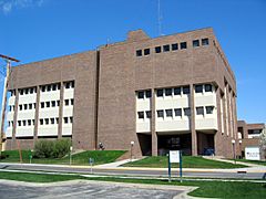
Pottawattamie County Courthouse
|
|

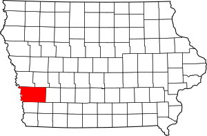
Location within the U.S. state of Iowa
|
|
 Iowa's location within the U.S. |
|
| Country | |
| State | |
| Founded | September 21, 1848 |
| Named for | Potawatomi tribe |
| Seat | Council Bluffs |
| Largest city | Council Bluffs |
| Area | |
| • Total | 959 sq mi (2,480 km2) |
| • Land | 950 sq mi (2,500 km2) |
| • Water | 8.9 sq mi (23 km2) 0% |
| Population
(2020)
|
|
| • Total | 93,667 |
| • Estimate
(2023)
|
93,179 |
| • Density | 97.67/sq mi (37.711/km2) |
| Time zone | UTC−6 (Central) |
| • Summer (DST) | UTC−5 (CDT) |
| Congressional district | 4th |
Pottawattamie County is a county in the state of Iowa. It was named after the Potawatomi Native American tribe. In 2020, about 93,667 people lived here. This makes it the tenth-largest county in Iowa by population. The main city and government center is Council Bluffs.
Pottawattamie County is part of the larger Omaha–Council Bluffs area. This area includes parts of both Nebraska and Iowa.
Contents
About the Land and Area
Pottawattamie County covers about 959 square miles. Most of this is land, with a small part being water. It is the second-largest county in Iowa based on its total area. The county is located in Iowa's Loess Hills. This is a unique area with hills made of fine, wind-blown soil. Long ago, The Mormon Trail passed through here, with a stop called Kanesville.
A special part of the county, Carter Lake, is actually on the other side of the Missouri River. This happened because the river changed its path over time. You have to go through Nebraska to reach Carter Lake by road. There is no direct bridge from the rest of Pottawattamie County.
Main Roads and Highways
 Interstate 29
 Interstate 80
 Interstate 480
 Interstate 680
 Interstate 880
 U.S. Highway 6
 U.S. Highway 59
 U.S. Highway 275
 Iowa Highway 83
 Iowa Highway 92
 Iowa Highway 165
 Iowa Highway 191
 Iowa Highway 192
Neighboring Counties
- Harrison County (north)
- Shelby County (northeast)
- Cass County (east)
- Montgomery County (southeast)
- Mills County (south)
- Sarpy County, Nebraska (southwest)
- Douglas County, Nebraska (west)
- Washington County, Nebraska (northwest)
Protected Natural Areas
- DeSoto National Wildlife Refuge (part of it is in the county)
Population Information
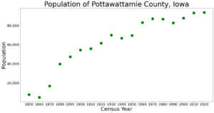
| Historical population | |||
|---|---|---|---|
| Census | Pop. | %± | |
| 1850 | 7,828 | — | |
| 1860 | 4,968 | −36.5% | |
| 1870 | 16,893 | 240.0% | |
| 1880 | 39,850 | 135.9% | |
| 1890 | 47,430 | 19.0% | |
| 1900 | 54,336 | 14.6% | |
| 1910 | 55,832 | 2.8% | |
| 1920 | 61,550 | 10.2% | |
| 1930 | 69,888 | 13.5% | |
| 1940 | 66,756 | −4.5% | |
| 1950 | 69,682 | 4.4% | |
| 1960 | 83,102 | 19.3% | |
| 1970 | 86,991 | 4.7% | |
| 1980 | 86,561 | −0.5% | |
| 1990 | 82,628 | −4.5% | |
| 2000 | 87,704 | 6.1% | |
| 2010 | 93,158 | 6.2% | |
| 2020 | 93,667 | 0.5% | |
| 2023 (est.) | 93,179 | 0.0% | |
| U.S. Decennial Census 1790-1960 1900-1990 1990-2000 2010-2018 |
|||
2020 Census Details
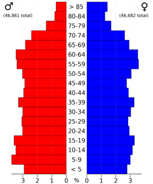
In 2020, the county had 93,667 people. This means there were about 98 people living in each square mile. Most people (94.09%) said they belonged to one race. There were almost 40,000 homes, and about 37,000 of them were lived in.
| Race | Num. | Perc. |
|---|---|---|
| White (not Hispanic) | 79,181 | 84.53% |
| Black or African American (not Hispanic) | 1,836 | 2% |
| Native American (not Hispanic) | 391 | 0.42% |
| Asian (not Hispanic) | 773 | 0.83% |
| Pacific Islander (not Hispanic) | 76 | 0.08% |
| Other/Mixed (not Hispanic) | 3,750 | 4% |
| Hispanic or Latino | 7,660 | 8.2% |
2010 Census Details
The 2010 census counted 93,158 people in the county. The population density was about 98 people per square mile. There were 39,330 housing units. About 36,775 of these homes were occupied.
Towns and Communities

Cities in the County
Small Unincorporated Community
Census-Designated Places (CDPs)
These are areas that are like towns but are not officially incorporated as cities.
Townships in Pottawattamie County
A township is a small area of land, often with its own local government.
- Belknap
- Boomer
- Carson
- Center
- Crescent
- Garner
- Grove
- Hardin
- Hazel Dell
- James
- Kane
- Keg Creek
- Knox
- Lake
- Layton
- Lewis
- Lincoln
- Macedonia
- Minden
- Neola
- Norwalk
- Pleasant
- Rockford
- Silver Creek
- Valley
- Washington
- Waveland
- Wright
- York
Cities by Population Size
This table shows the cities and towns in Pottawattamie County. They are listed from largest to smallest population, based on the 2020 census.
† county seat (the main city where the county government is located)
| Rank | City/Town/etc. | Type | Population (2020 Census) |
|---|---|---|---|
| 1 | † Council Bluffs | City | 62,799 |
| 2 | Carter Lake | City | 3,791 |
| 3 | Avoca | City | 1,683 |
| 4 | Oakland | City | 1,524 |
| 5 | Treynor | City | 1,032 |
| 6 | Underwood | City | 954 |
| 7 | Neola | City | 918 |
| 8 | Carson | City | 766 |
| 9 | Walnut | City | 747 |
| 10 | Crescent | City | 628 |
| 11 | Minden | City | 600 |
| 12 | Macedonia | City | 267 |
| 13 | Hancock | City | 200 |
| 14 | McClelland | City | 146 |
| 15 | Bentley | CDP | 93 |
| 16 | Weston | CDP | 78 |
| 17 | Loveland | CDP | 36 |
| 18 | Shelby (partially in Shelby County) | City | 11 (727 total) |
Law Enforcement
The Pottawattamie County Sheriff's Office keeps the peace in the county. It has 51 sworn deputies, who are like police officers. There are also 13 reserve deputies and 92 detention officers. Eight other staff members help with daily tasks. The main office is in Council Bluffs, Iowa.
Schools and Education
Many school districts serve the children of Pottawattamie County.
- Atlantic Community School District
- AHSTW Community School District
- Council Bluffs Community School District
- Glenwood Community School District
- Griswold Community School District
- Lewis Central Community School District
- Missouri Valley Community School District
- Red Oak Community School District
- Riverside Community School District
- Treynor Community School District
- Tri-Center Community School District
- Underwood Community School District
The county also has a special state-run school called the Iowa School for the Deaf. Some school districts have changed over time. These include the former A-H-S-T Community School District and Walnut Community School District.
Famous People from Pottawattamie County
- Nina Korgan (1916—2009), a well-known women’s fast-pitch softball pitcher.
See also
 In Spanish: Condado de Pottawattamie para niños
 | Delilah Pierce |
 | Gordon Parks |
 | Augusta Savage |
 | Charles Ethan Porter |


