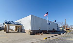
Underwood, Iowa facts for kids
Quick facts for kids
Underwood, Iowa
|
|
|---|---|

Underwood, Iowa Memorial Hall
|
|

Location of Underwood, Iowa
|
|
| Country | |
| State | |
| County | Pottawattamie |
| Township | Norwalk |
| Area | |
| • Total | 1.11 sq mi (2.89 km2) |
| • Land | 1.09 sq mi (2.82 km2) |
| • Water | 0.03 sq mi (0.07 km2) |
| Elevation | 1,060 ft (320 m) |
| Population
(2020)
|
|
| • Total | 954 |
| • Density | 876.03/sq mi (338.19/km2) |
| Time zone | UTC-6 (Central (CST)) |
| • Summer (DST) | UTC-5 (CDT) |
| ZIP code |
51576
|
| Area code(s) | 712 |
| FIPS code | 19-79500 |
| GNIS feature ID | 2397083 |
| Website | City of Underwood |
Underwood is a small town located in Pottawattamie County, Iowa, in the United States. It's a friendly community where about 954 people lived according to the 2020 census.
Contents
History of Underwood, Iowa
Underwood is part of Norwalk Township. The early history of this area helps us understand how the town grew.
Early Settlers and Mills
The first people to settle in this area arrived between 1845 and 1850. In 1847, two important mills were built on Mosquito Creek. There was a flour mill to grind grain and a saw mill to cut wood.
However, in 1850, a big flood destroyed the flour mill. Even so, more homes were built near the saw mill and the first school, which opened in 1863. This small settlement became known as Downsville. It even had its own post office.
How Underwood Got Its Name
The town of Underwood began in 1869 when the Chicago, Rock Island and Pacific Railroad came through. It was built about three miles northeast of Downsville. Eventually, Downsville was left behind and disappeared, though its cemetery remains.
In 1882, another railroad, the Chicago, Milwaukee and St. Paul line, built a station here. They also added a water tank and a switch for trains. These new railroad features were built on land owned by two local farmers.
The town was named Underwood after the first engineer who drove a train on the Milwaukee tracks. Two farmers helped by clearing a path through their cornfields for the depot. This path later became the town's "Main Street."
Growing as a Town
Underwood officially became a town in 1902. The town council appointed a marshal to keep order and built a jail. They also started building sidewalks.
In 1903, the town grew with its first new addition of land. The old school building was moved and became the town hall. By 1905, the town bought five street lamps and extended its sidewalks and streets.
Between 1907 and 1910, modern services arrived. The telephone came to town, a water system was installed, and more cement sidewalks were built. A fire department was organized in 1917 to protect the community.
In 1926, a new, larger school was built for about $75,000. It had 62 high school students and 116 younger students, taught by seven teachers.
Recent Developments
In 1965, sewer pipes were installed in the town. A new Western Electric plant was completed in 1974, which helped update the town's sewer system.
More recently, in 2012, Jack Link's opened a distribution center in Underwood. They also gave a $15,000 donation to the community.
Geography and Location
Underwood, Iowa, covers about 0.46 square miles (1.2 square kilometers) of land. It is located in a special area called the Loess Hills. These hills are a unique prairie formed by windblown soil that was deposited after the last Ice Age.
Population Changes Over Time
| Historical populations | ||
|---|---|---|
| Year | Pop. | ±% |
| 1910 | 271 | — |
| 1920 | 260 | −4.1% |
| 1930 | 261 | +0.4% |
| 1940 | 251 | −3.8% |
| 1950 | 278 | +10.8% |
| 1960 | 337 | +21.2% |
| 1970 | 424 | +25.8% |
| 1980 | 448 | +5.7% |
| 1990 | 515 | +15.0% |
| 2000 | 688 | +33.6% |
| 2010 | 917 | +33.3% |
| 2020 | 954 | +4.0% |
| Source: and Iowa Data Center Source: |
||
What the 2020 Census Shows
The census in 2020 counted 954 people living in Underwood. There were 344 households and 257 families. The town had about 876 people per square mile (338 people per square kilometer).
Most residents, about 95.4%, were White. About 3.1% of the population identified as Hispanic or Latino.
Many households, 46.2%, had children under 18 living with them. The average age in Underwood was 35.2 years. About 34.6% of residents were under 20 years old. The population was split evenly, with 50.0% male and 50.0% female.
What the 2010 Census Showed
In the census of 2010, Underwood had 917 people living there. There were 330 households and 260 families. The population density was about 1993.5 people per square mile (770 people per square kilometer).
About 97.8% of the town's residents were White. About 1.3% of the population was Hispanic or Latino.
About 46.1% of households had children under 18. The average age was 35.2 years. About 33.2% of residents were under 18 years old. The town had slightly more females (51.1%) than males (48.9%).
Education in Underwood
The Underwood Community School District is responsible for the schools that serve the town of Underwood.
See also
 In Spanish: Underwood (Iowa) para niños
 | Jewel Prestage |
 | Ella Baker |
 | Fannie Lou Hamer |


