Montgomery County, Iowa facts for kids
Quick facts for kids
Montgomery County
|
|
|---|---|

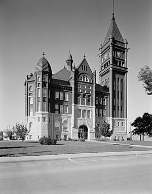
Montgomery County Courthouse
|
|

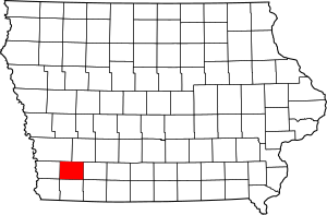
Location within the U.S. state of Iowa
|
|
 Iowa's location within the U.S. |
|
| Country | |
| State | |
| Founded | 1851 |
| Named for | Richard Montgomery |
| Seat | Red Oak |
| Largest city | Red Oak |
| Area | |
| • Total | 425 sq mi (1,100 km2) |
| • Land | 424 sq mi (1,100 km2) |
| • Water | 0.9 sq mi (2 km2) 0.2% |
| Population
(2020)
|
|
| • Total | 10,330 |
| • Density | 24.31/sq mi (9.385/km2) |
| Time zone | UTC−6 (Central) |
| • Summer (DST) | UTC−5 (CDT) |
| Congressional district | 3rd |
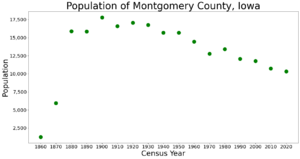
Montgomery County is a county located in the southwestern part of Iowa, a state in the United States. In 2020, about 10,330 people lived here. The population has changed over time, with fewer people living here now compared to the early 1900s. This is partly because more people moved to cities and there are fewer family farms.
The main town and county seat is Red Oak. The county was started in 1851 by people who moved from eastern areas. It was named to honor Richard Montgomery. He was a general during the American Revolutionary War who died in 1775.
Montgomery County has mostly been a rural area, meaning it has a lot of farms. The land was first measured and mapped in 1852. It is also known as the place where the Villisca axe murders happened in 1912. This event is still an unsolved mystery. Clyde Cessna, who started the famous Cessna Aircraft Company, was born in this county.
Contents
Geography of Montgomery County
According to the U.S. Census Bureau, Montgomery County covers about 425 square miles. Most of this area, about 424 square miles, is land. Only a small part, about 0.9 square miles, is water.
Main Roads in the County
These are the major highways that pass through Montgomery County:
Neighboring Counties
Montgomery County shares borders with these other counties:
- Pottawattamie County (to the northwest)
- Cass County (to the northeast)
- Adams County (to the east)
- Page County (to the south)
- Mills County (to the west)
Population Information
The population of Montgomery County has been counted many times over the years. This helps us understand how many people live here and how the number changes.
| Historical population | |||
|---|---|---|---|
| Census | Pop. | %± | |
| 1860 | 1,256 | — | |
| 1870 | 5,934 | 372.5% | |
| 1880 | 15,895 | 167.9% | |
| 1890 | 15,848 | −0.3% | |
| 1900 | 17,803 | 12.3% | |
| 1910 | 16,604 | −6.7% | |
| 1920 | 17,048 | 2.7% | |
| 1930 | 16,752 | −1.7% | |
| 1940 | 15,697 | −6.3% | |
| 1950 | 15,685 | −0.1% | |
| 1960 | 14,467 | −7.8% | |
| 1970 | 12,781 | −11.7% | |
| 1980 | 13,413 | 4.9% | |
| 1990 | 12,076 | −10.0% | |
| 2000 | 11,771 | −2.5% | |
| 2010 | 10,740 | −8.8% | |
| 2020 | 10,330 | −3.8% | |
| 2023 (est.) | 10,139 | −5.6% | |
| U.S. Decennial Census 1790-1960 1900-1990 1990-2000 2010-2018 |
|||
2020 Census Details

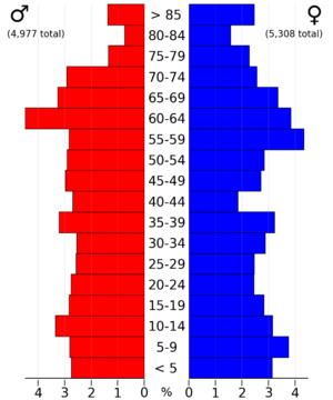
The 2020 census counted 10,330 people living in Montgomery County. This means there were about 24 people for every square mile. Most people (96.38%) said they belonged to one race. About 90.29% were non-Hispanic White. Other groups included Black, Hispanic, Native American, Asian, and Native Hawaiian or Pacific Islander people. Some people also reported being of more than one race.
There were 5,007 places where people could live, called housing units. Out of these, 4,456 were being lived in.
2010 Census Details
The 2010 census recorded 10,740 people in the county. The population density was similar, with about 25 people per square mile. At that time, there were 5,239 housing units, and 4,558 of them were occupied.
Towns and Areas
Montgomery County has several towns and communities.
Cities in the County
Unincorporated Community
- Pittsburg
- Tenville
Former Towns
Over time, some towns in the county no longer exist. These include:
- Alix (1895-1898)
- Arlington
- Biddick (1893-1902)
- Carr's Point (1865-1870)
- Climax (1871-1901)
- Coe's Grove (1858-1869)
- Flora (1859)
- Frankfort (1856-1878) - This was the county seat from 1864 to 1865.
- Hawthorne (1871-1908)
- Oro (1856-1858)
- Ross Grove (1855-1863)
- Rossville (1855)
- Sciola (1855-1905)
- Wales (1886-1901)
- Wallace (1875-1878)
- Wilson (1870-1879)
Townships
- Douglas
- East
- Frankfort
- Garfield
- Grant
- Lincoln
- Pilot Grove
- Red Oak
- Scott
- Sherman
- Washington
- West
City Population Ranking
This table shows the cities in Montgomery County, ranked by their population from the 2020 census.
† county seat
| Rank | City/Town/etc. | Municipal type | Population (2020 Census) |
|---|---|---|---|
| 1 | † Red Oak | City | 5,596 |
| 2 | Villisca | City | 1,132 |
| 3 | Stanton | City | 678 |
| 4 | Elliott | City | 338 |
| 5 | Grant | City | 86 |
| 6 | Coburg | City | 26 |
See also
 In Spanish: Condado de Montgomery (Iowa) para niños
 | Selma Burke |
 | Pauline Powell Burns |
 | Frederick J. Brown |
 | Robert Blackburn |


