Adams County, Iowa facts for kids
Quick facts for kids
Adams County
|
|
|---|---|

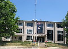
Adams County Courthouse in Corning
|
|

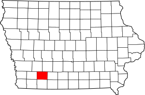
Location within the U.S. state of Iowa
|
|
 Iowa's location within the U.S. |
|
| Country | |
| State | |
| Founded | March 12, 1853 |
| Named for | John Adams |
| Seat | Corning |
| Largest city | Corning |
| Area | |
| • Total | 426 sq mi (1,100 km2) |
| • Land | 423 sq mi (1,100 km2) |
| • Water | 2.1 sq mi (5 km2) 0.5% |
| Population
(2020)
|
|
| • Total | 3,704 |
| • Estimate
(2023)
|
3,544 |
| • Density | 8.695/sq mi (3.357/km2) |
| Time zone | UTC−6 (Central) |
| • Summer (DST) | UTC−5 (CDT) |
| Congressional district | 3rd |
Adams County is a county located in the state of Iowa in the United States. In 2020, about 3,704 people lived here. This makes it Iowa's county with the fewest people. The main town and county seat is Corning.
Contents
History of Adams County
Adams County was created by Iowa's state government in 1851. It was named after either John Adams, who was the second President of the United States, or his son, John Quincy Adams, the sixth president. Different sources say different things.
The county officially started operating on March 12, 1853. At first, it was bigger, but parts of it were later used to create Montgomery and Union counties.
The first county seat, or main town, was Quincy, Iowa. In 1872, the county seat was moved to Corning, where it is today.
Geography of Adams County
Adams County covers a total area of about 426 square miles. Most of this area, about 423 square miles, is land. The remaining 2.1 square miles, or 0.5%, is water.
Main Roads in Adams County
Neighboring Counties
Adams County shares borders with several other counties:
- Cass County to the northwest
- Adair County to the northeast
- Union County to the east
- Taylor County to the south
- Montgomery County to the west
Population and People
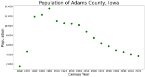
| Historical population | |||
|---|---|---|---|
| Census | Pop. | %± | |
| 1860 | 1,533 | — | |
| 1870 | 4,614 | 201.0% | |
| 1880 | 11,888 | 157.7% | |
| 1890 | 12,292 | 3.4% | |
| 1900 | 13,601 | 10.6% | |
| 1910 | 10,998 | −19.1% | |
| 1920 | 10,521 | −4.3% | |
| 1930 | 10,437 | −0.8% | |
| 1940 | 10,156 | −2.7% | |
| 1950 | 8,753 | −13.8% | |
| 1960 | 7,468 | −14.7% | |
| 1970 | 6,322 | −15.3% | |
| 1980 | 5,731 | −9.3% | |
| 1990 | 4,866 | −15.1% | |
| 2000 | 4,482 | −7.9% | |
| 2010 | 4,029 | −10.1% | |
| 2020 | 3,704 | −8.1% | |
| 2023 (est.) | 3,544 | −12.0% | |
| U.S. Decennial Census 1790-1960 1900-1990 1990-2000 2010-2018 |
|||
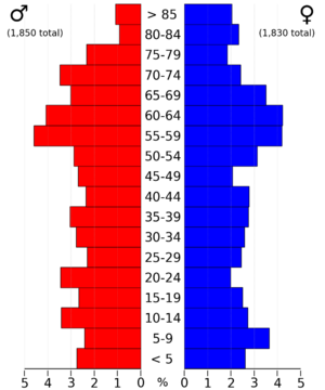
Population in 2020
The 2020 census counted 3,704 people living in Adams County. This means there were about 9 people for every square mile. Most people, about 97%, said they belonged to one race. About 94% were White, 1.13% were Hispanic, and smaller numbers were Black, Native American, or Asian.
There were 1,888 homes in the county, and 1,614 of them had people living in them.
Population in 2010
In 2010, there were 4,029 people living in Adams County. There were 1,715 households, which are groups of people living together in a home. The average number of people in each household was 2.28.
Most people, about 98.1%, were white. Other groups included Asian, American Indian, and Black or African American people. About 0.9% of the population was of Hispanic or Latino origin.
Many families had children under 18 living with them. The average age of people in the county was 46.7 years old.
Towns and Cities in Adams County
Here are the communities located in Adams County:
Cities and Towns
- Carbon
- Carl
- Corning (This is the county seat, the main town)
- Lenox (Most of this town is actually in Taylor County)
- Mt. Etna
- Nodaway
- Prescott
- Williamson
Population Ranking of Communities (2020 Census)
This table shows the population of the main towns in Adams County, from largest to smallest, based on the 2020 census.
† county seat
| Rank | City/Town/etc. | Municipal type | Population (2020 Census) |
|---|---|---|---|
| 1 | † Corning | City | 1,564 |
| 2 | Prescott | City | 191 |
| 3 | Nodaway | City | 74 |
| 4 | Carbon | City | 36 |
See also
 In Spanish: Condado de Adams (Iowa) para niños
 | Chris Smalls |
 | Fred Hampton |
 | Ralph Abernathy |


