Taylor County, Iowa facts for kids
Quick facts for kids
Taylor County
|
|
|---|---|
|
|
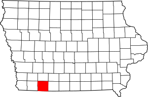
Location within the U.S. state of Iowa
|
|
 Iowa's location within the U.S. |
|
| Country | |
| State | |
| Founded | 1847 |
| Named for | Zachary Taylor |
| Seat | Bedford |
| Largest city | Bedford |
| Area | |
| • Total | 535 sq mi (1,390 km2) |
| • Land | 532 sq mi (1,380 km2) |
| • Water | 2.8 sq mi (7 km2) 0.5% |
| Population
(2020)
|
|
| • Total | 5,896 |
| • Estimate
(2023)
|
5,924 |
| • Density | 11.021/sq mi (4.255/km2) |
| Time zone | UTC−6 (Central) |
| • Summer (DST) | UTC−5 (CDT) |
| Congressional district | 3rd |
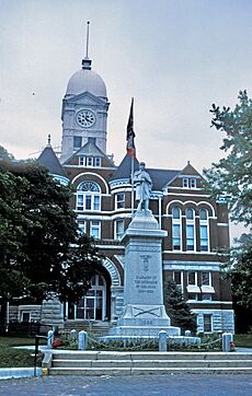
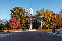
Taylor County is a place in Iowa, a state in the United States. It is called a county. In 2020, about 5,896 people lived here. This makes it one of the least populated counties in Iowa. The main town, or county seat, is Bedford. Taylor County was created in 1847. It was named after Zachary Taylor, who was a general and later a president.
Contents
Geography of Taylor County
Taylor County covers about 535 square miles. Most of this area is land, about 532 square miles. A small part, about 2.8 square miles, is water. This means water makes up about 0.5% of the county's total area.
Long ago, a part of Taylor County used to be part of Missouri.
Main Roads in Taylor County
These are the most important roads that go through Taylor County:
Neighboring Counties
Taylor County shares its borders with these other counties:
- Adams County to the north
- Ringgold County to the east
- Worth County, Missouri to the southeast
- Nodaway County, Missouri to the southwest
- Page County to the west
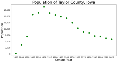
Population Information
| Historical population | |||
|---|---|---|---|
| Census | Pop. | %± | |
| 1850 | 204 | — | |
| 1860 | 3,590 | 1,659.8% | |
| 1870 | 6,989 | 94.7% | |
| 1880 | 15,635 | 123.7% | |
| 1890 | 16,384 | 4.8% | |
| 1900 | 18,784 | 14.6% | |
| 1910 | 16,312 | −13.2% | |
| 1920 | 15,514 | −4.9% | |
| 1930 | 14,859 | −4.2% | |
| 1940 | 14,258 | −4.0% | |
| 1950 | 12,420 | −12.9% | |
| 1960 | 10,288 | −17.2% | |
| 1970 | 8,790 | −14.6% | |
| 1980 | 8,353 | −5.0% | |
| 1990 | 7,114 | −14.8% | |
| 2000 | 6,958 | −2.2% | |
| 2010 | 6,317 | −9.2% | |
| 2020 | 5,896 | −6.7% | |
| 2023 (est.) | 5,924 | −6.2% | |
| U.S. Decennial Census 1790-1960 1900-1990 1990-2000 2010-2018 |
|||
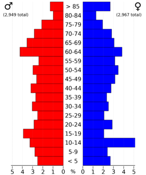
2020 Population Count
In 2020, the official count showed 5,896 people living in Taylor County. This means there were about 11 people per square mile. Most people, about 95.76%, said they belonged to one race. There were 2,885 homes in the county, and 2,506 of them were lived in.
Here's a quick look at the different groups of people in Taylor County in 2020:
| Group | Number | Percent |
|---|---|---|
| White | 5,304 | 90% |
| Black or African American | 1 | 0.02% |
| Native American | 13 | 0.22% |
| Asian | 15 | 0.25% |
| Pacific Islander | 1 | 0.02% |
| Other/Mixed | 163 | 2.76% |
| Hispanic or Latino | 399 | 6.76% |
2010 Population Count
The count in 2010 showed 6,317 people living in the county. There were 3,107 homes, and 2,679 of them were lived in.
Towns and Communities
Taylor County has several towns and smaller communities.
Cities
- Bedford
- Blockton
- Clearfield (partially)
- Conway
- Gravity
- Lenox (partially)
- New Market
- Sharpsburg
Special Place (CDP)
- Athelstan is a "Census-designated place." This means it's a community that the census bureau counts, but it's not officially a city.
Townships
Counties are often divided into smaller areas called townships. Here are the townships in Taylor County:
- Bedford
- Benton
- Clayton
- Dallas
- Gay
- Grant
- Grove
- Holt
- Jackson
- Jefferson
- Marshall
- Mason
- Nodaway
- Platte
- Polk
- Ross
- Washington
Community Sizes
This table shows the population of the cities and towns in Taylor County, based on the 2020 census. † This symbol means it's the main town or county seat.
| Rank | City/Town/etc. | Type | Population (2020 Census) |
|---|---|---|---|
| 1 | † Bedford | City | 1,508 |
| 2 | Lenox (partially in Adams County) | City | 1,339 (1,339 total) |
| 3 | New Market | City | 385 |
| 4 | Clearfield (partially in Ringgold County) | City | 272 (278 total) |
| 5 | Gravity | City | 154 |
| 6 | Blockton | City | 125 |
| 7 | Sharpsburg | City | 72 |
| 8 | Conway | City | 17 |
| 9 | Athelstan | CDP | 6 |
Education in Taylor County
Many school districts serve the students in Taylor County. Here are some of them:
- Bedford Community School District
- Clarinda Community School District
- Corning Community School District
- Diagonal Community School District
- Lenox Community School District
- Mount Ayr Community School District
- Villisca Community School District
Some school districts that used to be in the area have now joined with others:
- Clearfield Community School District - This district closed on July 1, 2014.
- New Market Community School District - This district closed on July 1, 2008.
See also
 In Spanish: Condado de Taylor (Iowa) para niños
 | Madam C. J. Walker |
 | Janet Emerson Bashen |
 | Annie Turnbo Malone |
 | Maggie L. Walker |


