Page County, Iowa facts for kids
Quick facts for kids
Page County
|
|
|---|---|

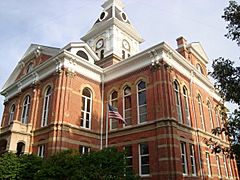
The courthouse in Clarinda is on the NRHP.
|
|

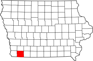
Location within the U.S. state of Iowa
|
|
 Iowa's location within the U.S. |
|
| Country | |
| State | |
| Founded | February 24, 1847 |
| Named for | John Page |
| Seat | Clarinda |
| Largest city | Clarinda |
| Area | |
| • Total | 535 sq mi (1,390 km2) |
| • Land | 535 sq mi (1,390 km2) |
| • Water | 0.5 sq mi (1 km2) 0.1% |
| Population
(2020)
|
|
| • Total | 15,211 |
| • Density | 28.432/sq mi (10.978/km2) |
| Time zone | UTC−6 (Central) |
| • Summer (DST) | UTC−5 (CDT) |
| Congressional district | 3rd |
Page County is a county located in the state of Iowa. A county is like a smaller region within a state. In 2020, about 15,211 people lived here. The main town, or county seat, is Clarinda. The county is named after Captain John Page. He was a soldier who was hurt during the Battle of Palo Alto.
Contents
Geography
Page County covers a total area of about 535 square miles. Almost all of this area is land. Only a tiny part, about 0.5 square miles, is water.
Major roads
These are the main roads that go through Page County:
Public transport
- Jefferson Lines offers bus services in the area.
Neighboring counties
Page County shares borders with these other counties:
- Montgomery County (to the north)
- Taylor County (to the east)
- Nodaway County, Missouri (to the southeast)
- Atchison County, Missouri (to the southwest)
- Fremont County (to the west)
Population Information
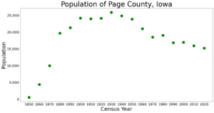
| Historical population | |||
|---|---|---|---|
| Census | Pop. | %± | |
| 1850 | 551 | — | |
| 1860 | 4,419 | 702.0% | |
| 1870 | 9,975 | 125.7% | |
| 1880 | 19,667 | 97.2% | |
| 1890 | 21,341 | 8.5% | |
| 1900 | 24,187 | 13.3% | |
| 1910 | 24,002 | −0.8% | |
| 1920 | 24,137 | 0.6% | |
| 1930 | 25,904 | 7.3% | |
| 1940 | 24,887 | −3.9% | |
| 1950 | 23,921 | −3.9% | |
| 1960 | 21,023 | −12.1% | |
| 1970 | 18,537 | −11.8% | |
| 1980 | 19,063 | 2.8% | |
| 1990 | 16,870 | −11.5% | |
| 2000 | 16,976 | 0.6% | |
| 2010 | 15,932 | −6.1% | |
| 2020 | 15,211 | −4.5% | |
| 2023 (est.) | 15,014 | −5.8% | |
| U.S. Decennial Census 1790-1960 1900-1990 1990-2000 2010-2018 |
|||
2020 Census Details
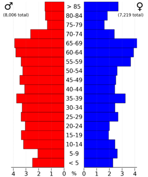
In 2020, the census counted 15,211 people in Page County. This means there were about 28 people living in each square mile. Most people, about 95.71%, said they belonged to one race. There were almost 7,000 homes, and most of them were lived in.
Most people in Page County are White. There are also smaller groups of people who are Black or African American, Native American, Asian, or from other backgrounds. About 3.1% of the population is Hispanic or Latino.
Towns and areas
Cities
Townships
Townships are smaller areas within a county. Here are the townships in Page County:
- Amity
- Buchanan
- Colfax
- Douglas
- East River
- Fremont
- Grant
- Harlan
- Lincoln
- Morton
- Nebraska
- Nodaway
- Pierce
- Tarkio
- Valley
- Washington
City populations
This table shows how many people live in each city in Page County, based on the 2020 census.
† county seat
| Rank | City/Town/etc. | Type | Population (2020 Census) |
|---|---|---|---|
| 1 | † Clarinda | City | 5,369 |
| 2 | Shenandoah (partially in Fremont County) | City | 4,925 (4,925 total) |
| 3 | Essex | City | 722 |
| 4 | Coin | City | 176 |
| 5 | College Springs | City | 172 |
| 6 | Shambaugh | City | 159 |
| 7 | Braddyville | City | 147 |
| 8 | Yorktown | City | 60 |
| 9 | Northboro | City | 52 |
| 10 | Blanchard | City | 29 |
| 11 | Hepburn | City | 26 |
History
On December 11, 1991, the Page County Courthouse had a big fire. The fire likely started in the attic and spread. Many fire departments from the area worked together to put out the fire and save the building. While repairs were being made, court services moved to other buildings in Clarinda and nearby areas. After two and a half years of work, the courthouse was ready to be used again in March 1994.
See also
 In Spanish: Condado de Page (Iowa) para niños
 | George Robert Carruthers |
 | Patricia Bath |
 | Jan Ernst Matzeliger |
 | Alexander Miles |


