Atchison County, Missouri facts for kids
Quick facts for kids
Atchison County
|
|
|---|---|

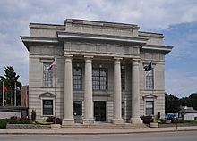
Atchison County Memorial Building
|
|

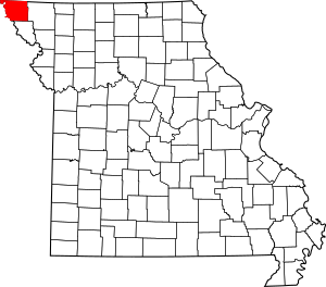
Location within the U.S. state of Missouri
|
|
 Missouri's location within the U.S. |
|
| Country | |
| State | |
| Founded | February 14, 1845 |
| Named for | David Rice Atchison |
| Seat | Rock Port |
| Largest city | Tarkio |
| Area | |
| • Total | 550 sq mi (1,400 km2) |
| • Land | 547 sq mi (1,420 km2) |
| • Water | 2.8 sq mi (7 km2) 0.5% |
| Population
(2020)
|
|
| • Total | 5,305 |
| • Density | 9.65/sq mi (3.72/km2) |
| Time zone | UTC−6 (Central) |
| • Summer (DST) | UTC−5 (CDT) |
| Congressional district | 6th |
Atchison County is a county located in the very northwest part of Missouri, a state in the United States. It's the county farthest to the northwest in Missouri.
In 2020, about 5,305 people lived here. The main town and county seat is Rock Port. The county was first called Allen County when it was created in 1843. It officially became Atchison County on February 14, 1845. It was named after David Rice Atchison, who was a U.S. Senator from Missouri.
Contents
Geography
Atchison County covers a total area of about 550 square miles. Most of this is land, with only a small part being water.
The western border of Atchison County is mostly the Missouri River. This river also separates Missouri from Nebraska. In 1867, a big flood changed the river's path. This created a piece of land called McKissick Island. Even though this island extends into Atchison County, the Supreme Court decided in 1904 that it belongs to Nebraska. People from Nebraska can only reach it by driving through Missouri.
A stream called State Line Slough (Missouri) is also found in Atchison County.
Neighboring Counties
Atchison County shares borders with several other counties:
- Fremont County, Iowa (to the north)
- Page County, Iowa (to the northeast)
- Nodaway County (to the east)
- Holt County (to the south)
- Richardson County, Nebraska (to the southwest)
- Nemaha County, Nebraska (to the west)
- Otoe County, Nebraska (to the northwest)
Main Roads
These are the major highways that run through Atchison County:
- Interstate 29
- U.S. Route 59
- U.S. Route 136
- U.S. Route 275
- Route 46
- Route 111
Public Transport
- Jefferson Lines provides bus services.
Population Information
| Historical population | |||
|---|---|---|---|
| Census | Pop. | %± | |
| 1850 | 1,678 | — | |
| 1860 | 4,649 | 177.1% | |
| 1870 | 8,440 | 81.5% | |
| 1880 | 14,556 | 72.5% | |
| 1890 | 15,533 | 6.7% | |
| 1900 | 16,501 | 6.2% | |
| 1910 | 13,604 | −17.6% | |
| 1920 | 13,008 | −4.4% | |
| 1930 | 13,421 | 3.2% | |
| 1940 | 12,897 | −3.9% | |
| 1950 | 11,127 | −13.7% | |
| 1960 | 9,213 | −17.2% | |
| 1970 | 9,240 | 0.3% | |
| 1980 | 8,605 | −6.9% | |
| 1990 | 7,457 | −13.3% | |
| 2000 | 6,430 | −13.8% | |
| 2010 | 5,685 | −11.6% | |
| 2020 | 5,305 | −6.7% | |
| U.S. Decennial Census 1790-1960 1900-1990 1990-2000 2010-2015 |
|||
In 2000, there were 6,430 people living in Atchison County. There were 2,722 households and 1,777 families. The population density was about 12 people per square mile. Most people living in the county were White (97%).
The median age in the county was 42 years old. This means half the people were younger than 42 and half were older.
2020 Census Update
Here's a quick look at the different groups of people in Atchison County from the 2020 census:
| Race | Number | Percentage |
|---|---|---|
| White (not Hispanic) | 4,983 | 94% |
| Black or African American (not Hispanic) | 22 | 0.41% |
| Native American (not Hispanic) | 25 | 0.5% |
| Asian (not Hispanic) | 7 | 0.13% |
| Pacific Islander (not Hispanic) | 0 | 0% |
| Other/Mixed (not Hispanic) | 195 | 3.7% |
| Hispanic or Latino | 73 | 1.4% |
Religion in the County
Atchison County is sometimes seen as being on the northern edge of the "Bible Belt," which is a region in the U.S. where Protestant Christianity is very common. The most common religions in Atchison County are:
- United Methodists
- Lutherans (LCMC)
- Southern Baptists
Education
Atchison County has several schools and a public library.
Public Schools
Here are the public school districts in the county:
- Fairfax R-III School District in Fairfax
- Fairfax Elementary School (grades PK-6)
- Fairfax High School (grades 7-12)
- Rock Port R-II School District in Rock Port
- Rock Port Elementary School (grades K-5)
- Rock Port High School (grades 6-12)
- Tarkio R-I School District in Tarkio
- Tarkio Elementary School (grades PK-5)
- Tarkio Middle School (grades 6-8)
- Tarkio High School (grades 9-12)
Private Schools
- Tarkio Academy in Tarkio (grades 7-12) – This was a non-religious school for boys, but it is now closed.
Public Libraries
- Atchison County Library
Communities
Cities
Village
Unincorporated Communities
These are smaller places that are not officially organized as cities or villages:
Townships
Atchison County is divided into 11 smaller areas called townships:
|
|
|
Notable People
Here are some well-known people who are from or have connections to Atchison County:
- Michael J. Burg - An actor.
- Zel Fischer - A Justice on the Missouri Supreme Court.
- Sam Graves - A U.S. Representative for Missouri's 6th Congressional District.
See also
 In Spanish: Condado de Atchison (Misuri) para niños
 | Janet Taylor Pickett |
 | Synthia Saint James |
 | Howardena Pindell |
 | Faith Ringgold |


