Holt County, Missouri facts for kids
Quick facts for kids
Holt County
|
|
|---|---|

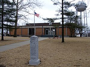
Holt County Courthouse in Oregon
|
|

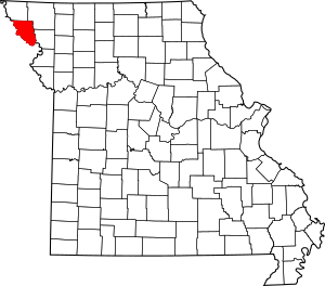
Location within the U.S. state of Missouri
|
|
 Missouri's location within the U.S. |
|
| Country | |
| State | |
| Founded | February 15, 1841 |
| Named for | David Rice Holt |
| Seat | Oregon |
| Largest city | Mound City |
| Area | |
| • Total | 470 sq mi (1,200 km2) |
| • Land | 463 sq mi (1,200 km2) |
| • Water | 7.7 sq mi (20 km2) 1.6% |
| Population
(2020)
|
|
| • Total | 4,223 |
| • Density | 8.99/sq mi (3.47/km2) |
| Time zone | UTC−6 (Central) |
| • Summer (DST) | UTC−5 (CDT) |
| Congressional district | 6th |
Holt County is a county in the northwestern part of Missouri, a state in the United States. In 2020, about 4,223 people lived there. The main town, or county seat, is Oregon.
The county was officially started on February 15, 1841. It was first called Nodaway County. Later, it was renamed after David Rice Holt (1803–1840). He was a state lawmaker from Platte County.
Contents
History of Holt County
You can find old books about Holt County's history online. These include The History of Holt County, Missouri from the Time of the Platte Purchase through 1916 and The History of Holt and Atchison Counties, Missouri (from 1882).
The first Post Office in Holt County opened in 1839. It was located near Oregon, by Thorp's Creek. This Post Office was known as Thorp's Mill and closed in 1841.
In 1972, the Holt County Historical Society was created. This group helps to preserve the county's past.
Holt County was affected by big floods in the Midwestern U.S. in 2019. About 30,000 acres of land were still underwater in late October. Some people expected the floodwater to freeze during the winter.
Geography of Holt County
Holt County covers a total area of 470 square miles. Most of this is land (463 square miles), and a small part (1.6%) is water (7.7 square miles).
Neighboring Counties
Holt County shares borders with several other counties:
- Atchison County (to the north)
- Nodaway County (to the northeast)
- Andrew County (to the southeast)
- Doniphan County, Kansas (to the south)
- Brown County, Kansas (to the southwest)
- Richardson County, Nebraska (to the west)
- Nemaha County, Nebraska (to the northwest)
Main Roads
Several important roads run through Holt County:
- Interstate 29
- U.S. Route 59
- U.S. Route 159
- Route 111
- Route 113
- Route 118
Population and People
| Historical population | |||
|---|---|---|---|
| Census | Pop. | %± | |
| 1850 | 3,957 | — | |
| 1860 | 6,550 | 65.5% | |
| 1870 | 11,652 | 77.9% | |
| 1880 | 15,509 | 33.1% | |
| 1890 | 15,469 | −0.3% | |
| 1900 | 17,083 | 10.4% | |
| 1910 | 14,539 | −14.9% | |
| 1920 | 14,084 | −3.1% | |
| 1930 | 12,720 | −9.7% | |
| 1940 | 12,476 | −1.9% | |
| 1950 | 9,833 | −21.2% | |
| 1960 | 7,885 | −19.8% | |
| 1970 | 6,654 | −15.6% | |
| 1980 | 6,882 | 3.4% | |
| 1990 | 6,034 | −12.3% | |
| 2000 | 5,351 | −11.3% | |
| 2010 | 4,912 | −8.2% | |
| 2020 | 4,223 | −14.0% | |
| U.S. Decennial Census 1790-1960 1900-1990 1990-2000 2010-2015 |
|||
In 2000, there were 5,351 people living in Holt County. The population density was about 12 people per square mile. Most people (98.47%) were White.
The population was spread out by age. About 23.80% of people were under 18 years old. The median age was 42 years. This means half the people were younger than 42 and half were older.
2020 Census Information
The 2020 census showed that 4,223 people lived in Holt County. Here's a look at the different groups of people:
| Race | Num. | Perc. |
|---|---|---|
| White (NH) | 3,992 | 94.53% |
| Black or African American (NH) | 4 | 0.1% |
| Native American (NH) | 30 | 0.71% |
| Asian (NH) | 2 | 0.05% |
| Pacific Islander (NH) | 0 | 0% |
| Other/Mixed (NH) | 128 | 3% |
| Hispanic or Latino | 67 | 1.6% |
Education in Holt County
Holt County has several public school districts and libraries.
Public Schools
- Craig R-III School District in Craig
- Craig Elementary School (Kindergarten to 6th grade)
- Craig High School (7th to 12th grade)
- Mound City R-II School District in Mound City
- Mound City Elementary School (Pre-Kindergarten to 4th grade)
- Mound City Middle School (5th to 8th grade)
- Mound City High School (9th to 12th grade)
- Nodaway-Holt R-VII School District in Maitland and Graham
- Nodaway-Holt Elementary School (Kindergarten to 6th grade)
- Nodaway-Holt Junior/Senior High School (7th to 12th grade)
- South Holt County R-I School District in Oregon
- South Holt County Elementary School (Kindergarten to 6th grade)
- South Holt County High School (7th to 12th grade)
Public Libraries
- Mound City Public Library
- Oregon Public Library
Places to Visit
Holt County has some interesting places to see:
- Loess Bluffs National Wildlife Refuge (used to be called Squaw Creek)
- Big Lake State Park on Big Lake
- St. John's Evangelical Lutheran Church (Corning, Missouri)
Towns and Communities
Holt County has several cities, villages, and other communities.
Cities
- Craig
- Forest City
- Maitland
- Mound City
- Oregon (This is the county seat, where the county government is located.)
Villages
Unincorporated Communities
These are smaller communities that are not officially part of a city or village.
Places That No Longer Exist
Some communities that once existed in Holt County are now gone:
- Curzon
- Kings Grove
- Napier
- Nichols Grove
- Richville
- Whig Valley
Famous People from Holt County
- Frank McGrath - An actor born in Mound City in 1903.
- Charles C. Moore - The 13th Governor of Idaho, who was born in Holt County.
- Roger Wehrli - An NFL athlete who was inducted into the Hall of Fame. He was born in New Point.
See also
 In Spanish: Condado de Holt (Misuri) para niños
 | Bessie Coleman |
 | Spann Watson |
 | Jill E. Brown |
 | Sherman W. White |

