
Loess Bluffs National Wildlife Refuge facts for kids
Quick facts for kids Loess Bluffs National Wildlife Refuge |
|
|---|---|
|
IUCN Category IV (Habitat/Species Management Area)
|
|

Snow Geese against the Loess Hills
|
|

Loess Bluffs National Wildlife Refuge
Location in the United States
|
|
| Location | Holt County, Missouri, United States |
| Nearest city | Mound City, Missouri |
| Area | 7,415 acres (30 km2) |
| Established | 1935 |
| Governing body | U.S. Fish and Wildlife Service |
| Website | Squaw Creek National Wildlife Refuge |

The Loess Bluffs National Wildlife Refuge is a special place in northwestern Missouri, United States. It was created in 1935 by President Franklin D. Roosevelt. Its main purpose is to be a safe home and breeding ground for birds that travel long distances, and for other wild animals.
This refuge covers about 7,350 acres (30 km2) of land. It sits along the eastern edge of the Missouri River floodplain, which is a flat area next to a river that can sometimes flood. The refuge is located south of Mound City, Missouri in Holt County, Missouri.
On its eastern side, the refuge is bordered by the Loess Hills. These are unique hills made of fine, wind-blown soil. There's a trail that goes to the top of these hills, which was built a long time ago by the Civilian Conservation Corps.
The refuge is especially exciting during spring and fall. This is when millions of ducks and geese, especially snow geese, pass through. They use the refuge as a stopping point on their long journey along the Central Flyway, which is like a major highway for birds. In winter, you can even see many bald eagles here. Sometimes, over 475 eagles have been counted! The refuge celebrates these eagle visits with special "Eagle Days" events. In February 2013, more than one million snow geese were counted at the refuge.
The refuge was originally named after Squaw Creek. This stream starts about 30 miles (48 km) north of the refuge. It is dammed to create the water areas you see in the refuge. Squaw Creek is one of the main creeks that feed the refuge. Another important creek is Davis Creek. Both creeks eventually join with Little Tarkio Creek and flow into the Missouri River.
Contents
A Look Back: The Refuge's History
The land that is now the refuge was once natural wetlands. These wet areas were used by many migratory birds. Before it became a refuge, some parts of this land were used as a private hunting area.
Draining the Land
In the early 1900s, people decided to drain these wetlands. They wanted to turn the wet land into farmland. In 1906, a big project was finished that created ditches to drain nearly 20,000 acres of land into the Missouri River. This was a huge effort, moving a lot of earth. Local newspapers celebrated, saying the land would now "blossom as the Rose" and that hunters would have to find new places to hunt.
However, draining the land didn't stop it from flooding. In 1908, just two years after the project was done, the land flooded again. In 1915, an even worse flood happened.
Creating the Refuge
On August 23, 1935, President Franklin D. Roosevelt signed an Executive order. This order called for the land to be changed back into a "refuge feeding and breeding ground for migratory birds and other wildlife." This was a big step, making it the first national wildlife refuge in Missouri.
The original plan was for the refuge to be 8,135 acres, but the government couldn't buy all the land. So, it was set at 7,415 acres. The plan also included managing the water from local creeks with different pools. The Civilian Conservation Corps (CCC), a group that helped people find work during the Great Depression, was given the job of restoring the wetlands. They helped build dikes, levees, and ditches to create the refuge as we know it today.
The refuge now has 15 large water areas, covering about 3,400 acres (14 km2). There are also about 14 miles (23 km) of dikes and levees, and 11 miles (18 km) of ditches.
Visiting the Refuge
The main office area of the refuge has a large room for presentations and an exhibit space. Here, you can learn more about the refuge and the unique Loess Hills. There's also a short trail, about 0.25-mile (0.40 km) long, built by the CCC. It climbs up 200 feet (60 m) to a high point where you can see amazing views of Missouri, Kansas, and Nebraska.
You can also drive a one-way, 10-mile (16 km) gravel road called the "Wild Goose Tour Loop." This road takes you around the edge of the refuge, offering great views of the wildlife. Many people visit the refuge each year to see the birds and enjoy nature.
Why the Name Change?
In January 2017, the refuge's name was officially changed to Loess Bluffs National Wildlife Refuge. Before that, it was known as Squaw Creek National Wildlife Refuge.
The U.S. Fish and Wildlife Service decided to change the name because the word "squaw" is no longer considered appropriate. It can be offensive, especially to Native American communities. Even though Squaw Creek is still an important part of the refuge's history and water system, the name needed to be updated to reflect modern values.
For many years, there had been discussions about the use of the word "squaw." For example, the Iowa tribe, who have a reservation nearby, had reopened a truck stop called Squaw Creek Truck Plaza in 2004. This shows that the name had been a topic of discussion for some time. The new name, Loess Bluffs, highlights the unique natural features of the area, like the Loess Hills.
Images for kids
-
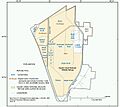
Map of the refuge
-
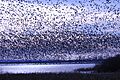
Snow geese at Bluff Pool. The refuge is a chokepoint for Central Flyway migration.


