Fortescue, Missouri facts for kids
Quick facts for kids
Fortescue, Missouri
|
|
|---|---|

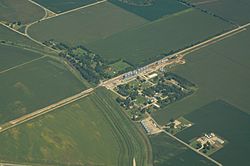
Aerial view of Fortescue, Missouri
|
|

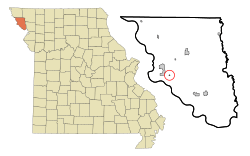
Location of Fortescue, Missouri
|
|
| Country | United States |
| State | Missouri |
| County | Holt |
| Township | Minton |
| Area | |
| • Total | 0.08 sq mi (0.20 km2) |
| • Land | 0.08 sq mi (0.20 km2) |
| • Water | 0.00 sq mi (0.00 km2) |
| Elevation | 860 ft (260 m) |
| Population
(2020)
|
|
| • Total | 21 |
| • Density | 272.73/sq mi (105.15/km2) |
| Time zone | UTC-6 (Central (CST)) |
| • Summer (DST) | UTC-5 (CDT) |
| ZIP code |
64437
|
| Area code(s) | 660 |
| FIPS code | 29-25228 |
| GNIS feature ID | 2396942 |
Fortescue is a small village located in the southwestern part of Holt County, Missouri, in the United States. According to the 2020 census, only 21 people live there, making it a very tiny community!
Contents
History of Fortescue
Fortescue was started around the year 1884. It was named by an early railroad promoter, who was someone who helped build and promote train lines. He decided to name the community after his mother's maiden name, which was also Fortesque. A post office, where people could send and receive mail, opened in Fortescue in 1884. It stayed open for many years, finally closing in 1973.
Geography of Fortescue
Fortescue is a very small village. It covers a total area of about 0.20 square kilometers (or 0.08 square miles), and all of this area is land.
The village is located near some interesting places:
- It is about 2.5 miles southeast of Big Lake.
- It is four miles southwest of Bigelow.
- It is about 3.5 miles north of the point where the states of Missouri, Kansas, and Nebraska meet. This meeting point is called a tri-point.
Fortescue is also found in the low-lying areas near the Missouri River. It is just a few miles west of the Loess Bluffs National Wildlife Refuge, which is a special place for wildlife.
Population and People
The number of people living in Fortescue has changed a lot over the years. Here's a quick look at how the population has changed:
| Historical population | |||
|---|---|---|---|
| Census | Pop. | %± | |
| 1920 | 153 | — | |
| 1930 | 141 | −7.8% | |
| 1940 | 175 | 24.1% | |
| 1950 | 117 | −33.1% | |
| 1960 | 78 | −33.3% | |
| 1970 | 63 | −19.2% | |
| 1980 | 51 | −19.0% | |
| 1990 | 46 | −9.8% | |
| 2000 | 51 | 10.9% | |
| 2010 | 32 | −37.3% | |
| 2020 | 21 | −34.4% | |
| U.S. Decennial Census | |||
Fortescue in 2010
In 2010, a census (a count of the population) showed that 32 people lived in Fortescue. These people lived in 10 different homes, and 9 of these were families.
The village had 16 housing units, which are places where people can live. All the people living in Fortescue at that time were White.
Most of the homes (80%) were married couples living together. Some homes (10%) had a male householder without a wife, and 10% were not families. No homes were made up of just one person.
The average size of a household was 3.20 people, and the average family had 3.33 people.
The average age of people in the village was 31 years old.
- About 34.4% of the people were under 18 years old.
- About 6.3% were between 18 and 24 years old.
- About 28.2% were between 25 and 44 years old.
- About 28.2% were between 45 and 64 years old.
- Only 3.1% were 65 years old or older.
When it came to gender, 43.8% of the people were male, and 56.3% were female.
See also
 In Spanish: Fortescue (Misuri) para niños
 | James Van Der Zee |
 | Alma Thomas |
 | Ellis Wilson |
 | Margaret Taylor-Burroughs |


