
Maitland, Missouri facts for kids
Quick facts for kids
Maitland, Missouri
|
|
|---|---|
 |
|

Location of Maitland, Missouri
|
|
| Country | United States |
| State | Missouri |
| County | Holt |
| Township | Clay |
| Area | |
| • Total | 0.31 sq mi (0.81 km2) |
| • Land | 0.31 sq mi (0.81 km2) |
| • Water | 0.00 sq mi (0.00 km2) |
| Elevation | 942 ft (287 m) |
| Population
(2020)
|
|
| • Total | 276 |
| • Density | 884.62/sq mi (341.07/km2) |
| Time zone | UTC-6 (Central (CST)) |
| • Summer (DST) | UTC-5 (CDT) |
| ZIP code |
64466
|
| Area code(s) | 660 |
| FIPS code | 29-45596 |
| GNIS feature ID | 2395819 |
Maitland is a small city located in Holt County, Missouri, in the United States. In 2020, about 276 people lived there. Long ago, Maitland was known as the "Bluegrass Mecca" because it had the biggest bluegrass farm in the whole world!
Contents
History of Maitland
Maitland was officially planned out in 1880. The town got its name from John Skirving Maitland. He was a surveyor for the Nodaway Valley Railroad. This railroad arrived in Maitland in 1880. John Fisk Barnard, who was in charge of the railroad, bought the land for the town. The railroad was later taken over by the Burlington Northern Railroad but is no longer in use.
Farming and Inventions
Maitland has always been a farming community. A famous farmer from Maitland was David Ward King. He invented and promoted something called the King road drag. This invention was basically two logs tied together. Horses or mules would drag them to smooth out dirt roads. It was like an early version of the modern road grader.
This invention was very important when Henry Ford started making cars. Before the King Road Drag, wet country roads would turn into thick mud. This made them almost impossible to drive on. The King Road Drag helped keep rural roads solid, even when wet. This meant cars could travel all the time. It also helped with rural mail delivery, making it easier for mail to reach people in the countryside.
The Bluegrass Mecca
In the early 1900s, Maitland claimed to have the largest bluegrass seed farm in the world. A farmer named John Q. Weller said his farm produced 10,000,000 pounds of seed. This was more than the entire state of Kentucky produced! Some years, Weller even got permission to pile huge amounts of seed on the city streets. During harvest time in late June or early July, the town would host a fun Bluegrass festival.
However, in the late 1950s and early 1960s, bluegrass seed production moved to other states like Idaho, Oregon, and Washington. Because of this, the Bluegrass Festival in Maitland stopped.
Geography of Maitland
Maitland is a small city. According to the United States Census Bureau, the city covers an area of about 0.30 square miles (0.81 square kilometers). All of this area is land.
Population Information
| Historical population | |||
|---|---|---|---|
| Census | Pop. | %± | |
| 1890 | 484 | — | |
| 1900 | 805 | 66.3% | |
| 1910 | 736 | −8.6% | |
| 1920 | 716 | −2.7% | |
| 1930 | 576 | −19.6% | |
| 1940 | 539 | −6.4% | |
| 1950 | 456 | −15.4% | |
| 1960 | 427 | −6.4% | |
| 1970 | 319 | −25.3% | |
| 1980 | 415 | 30.1% | |
| 1990 | 338 | −18.6% | |
| 2000 | 342 | 1.2% | |
| 2010 | 343 | 0.3% | |
| 2020 | 276 | −19.5% | |
| U.S. Decennial Census | |||
How Many People Live Here?
As of 2010, there were 343 people living in Maitland. These people lived in 144 households, and 100 of these were families. Most of the people living in Maitland were White (99.1%). A small number were Native American (0.3%) or from other backgrounds (0.6%). About 0.6% of the population was Hispanic or Latino.
The average age of people in Maitland was 37.4 years old. About 24.5% of residents were under 18 years old. Also, 14.3% of the people were 65 years or older. The population was almost evenly split between males (49.3%) and females (50.7%).
Education in Maitland
The local school district for Maitland is the Nodaway-Holt R-VII School District. Maitland has an elementary school. The junior-senior high school and the district's main office are located in Graham.
Notable People from Maitland
- Eleanor Sue Wright Owens (Author) - Born in 1935.
- David Ward King (Farmer and Inventor) - Lived from 1857 to 1920.
Images for kids
-
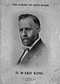
David Ward King, inventor of the King Road Drag

See also
 In Spanish: Maitland (Misuri) para niños
