Platte County, Missouri facts for kids
Quick facts for kids
Platte County
|
||
|---|---|---|

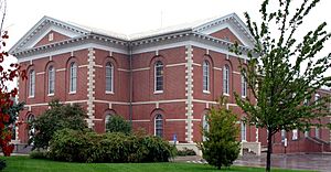
Platte County Courthouse
|
||
|
||

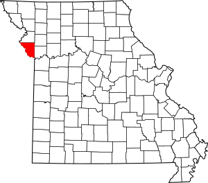
Location within the U.S. state of Missouri
|
||
 Missouri's location within the U.S. |
||
| Country | ||
| State | ||
| Founded | December 31, 1838 | |
| Named for | Platte River or Platte Purchase | |
| Seat | Platte City | |
| Largest city | Kansas City | |
| Area | ||
| • Total | 427 sq mi (1,110 km2) | |
| • Land | 420 sq mi (1,100 km2) | |
| • Water | 6.6 sq mi (17 km2) 1.5% | |
| Population
(2020)
|
||
| • Total | 106,718 | |
| • Density | 249.93/sq mi (96.50/km2) | |
| Time zone | UTC−6 (Central) | |
| • Summer (DST) | UTC−5 (CDT) | |
| Congressional district | 6th | |
Platte County is a place in northwestern Missouri. It's part of the big Kansas City metropolitan area. In 2020, about 106,718 people lived here. The main town, or county seat, is Platte City.
Platte County was created on December 31, 1838. It got its name from the Platte River and the Platte Purchase. The word Platte comes from French. It means a low or shallow stream. The Kansas City International Airport is also in Platte County.
Contents
Geography of Platte County

Platte County covers about 427 square miles. Most of this area, about 420 square miles, is land. The rest is water. The Missouri River forms the county's southwestern border with Kansas.
Neighboring Counties
Platte County shares borders with these other counties:
- Buchanan County (north)
- Clinton County (northeast)
- Clay County (east)
- Wyandotte County, Kansas (south)
- Leavenworth County, Kansas (southwest)
- Atchison County, Kansas (northwest)
Main Roads
Many important roads run through Platte County:
 Interstate 29
 Interstate 435
 Interstate 635
 U.S. Route 71
 Route 9
 Route 45
 Route 92
 Route 152
 Route 273
 Route 371
People of Platte County
| Historical population | |||
|---|---|---|---|
| Census | Pop. | %± | |
| 1840 | 8,913 | — | |
| 1850 | 16,845 | 89.0% | |
| 1860 | 18,350 | 8.9% | |
| 1870 | 17,352 | −5.4% | |
| 1880 | 17,366 | 0.1% | |
| 1890 | 16,278 | −6.3% | |
| 1900 | 16,193 | −0.5% | |
| 1910 | 14,429 | −10.9% | |
| 1920 | 13,996 | −3.0% | |
| 1930 | 13,819 | −1.3% | |
| 1940 | 13,862 | 0.3% | |
| 1950 | 14,973 | 8.0% | |
| 1960 | 23,350 | 55.9% | |
| 1970 | 32,081 | 37.4% | |
| 1980 | 46,341 | 44.4% | |
| 1990 | 57,867 | 24.9% | |
| 2000 | 73,781 | 27.5% | |
| 2010 | 89,322 | 21.1% | |
| 2020 | 106,718 | 19.5% | |
| U.S. Decennial Census 1790-1960 1900-1990 1990-2000 2010-2020 |
|||
In 2000, there were 73,781 people living in Platte County. The population density was about 176 people per square mile. Most people (91.45%) were White. About 3.49% were Black or African American. Around 3% of the population was Hispanic or Latino.
Many households (34.10%) had children under 18 living with them. The average household had about 2.49 people. The average family had about 3.00 people.
The median age in the county was 36 years old. This means half the people were younger than 36, and half were older.
2020 Census Data
The 2020 census showed the following racial makeup for Platte County:
| Race | Number | Percentage |
|---|---|---|
| White (not Hispanic) | 81,426 | 76.3% |
| Black or African American (not Hispanic) | 8,135 | 7.62% |
| Native American (not Hispanic) | 391 | 0.36% |
| Asian (not Hispanic) | 2,721 | 2.55% |
| Pacific Islander (not Hispanic) | 695 | 0.65% |
| Other/Mixed (not Hispanic) | 6,189 | 5.8% |
| Hispanic or Latino | 7,161 | 6.71% |
Education in Platte County
Platte County has several school districts and many schools.
School Districts
These school districts serve students from kindergarten to 12th grade:
- East Buchanan County C-1 School District
- North Kansas City 74 School District
- North Platte County R-I School District
- Park Hill School District
- Platte County R-III School District
- Smithville R-II School District
- West Platte County R-II School District
Public Schools
Here are some of the public schools in Platte County:
- North Platte R-I School District in Dearborn
- North Platte Elementary School (Grades PK-3)
- North Platte Intermediate School (Grades 4-6)
- North Platte Junior High School (Grades 7-8)
- North Platte High School (Grades 9-12)
- Park Hill School District in Kansas City
- Russell Jones Education Center (Special Education, K-12)
- Many elementary schools (Grades K-5) like Hopewell, Renner, Chinn, English Landing, Graden, Hawthorn, Line Creek, Prairie Point, Southeast, Tiffany Ridge, Union Chapel
- Gerner Family Early Education Center (Preschool)
- Middle schools (Grades 6-8) like Congress, Lakeview, Plaza, Walden
- Park Hill High School (Grades 9-12)
- Park Hill South High School (Grades 9-12)
- LEAD Innovation Studio (Grades 9-12)
- Platte County R-III School District in Platte City
- Elementary schools (Grades PK-5) like Donald D. Siegrist, Pathfinder, Compass, Barry
- Middle schools (Grades 6-8) like Platte Purchase, Platte City
- Platte County High School (Grades 9-12)
- West Platte County R-II School District in Weston
- Central Elementary School (Grades PK-6)
- West Platte County High School (Grades 7-12)
Private Schools
Platte County also has private schools:
- Clay-Platte Children's House Montessori School – Kansas City (Preschool-Grade 8)
- Martin Luther Academy – Kansas City (Grades K-8)
- Northland Christian Education System – Kansas City (Preschool-Grade 12)
- St. Therese School – Kansas City (Grades K-8)
- Prairie View KinderCare – Kansas City (Preschool)
- Christ Lutheran Pre-Kindergarten School – Platte Woods (Preschool)
- Our Savior Christian Academy - Platte City and Smithville (Preschool-Grade 12)
Public Libraries
- Mid-Continent Public Library
Communities in Platte County
Platte County has several cities and smaller villages.
Cities
- Camden Point
- Dearborn
- Edgerton
- Houston Lake
- Kansas City (partly in other counties)
- Lake Waukomis
- Northmoor
- Parkville
- Platte City (the county seat)
- Platte Woods
- Riverside
- Smithville (mostly in Clay County)
- Tracy
- Weatherby Lake
- Weston
Villages
Townships
These are areas within the county used for local government:
- Carroll
- Fair
- Fox
- Green
- Kickapoo
- Lee
- Marshall
- May
- Pawnee
- Pettis
- Preston
- Sioux
- Waldron
- Weston
Unincorporated Communities
These are smaller places that are not officially cities or villages:
See also
 In Spanish: Condado de Platte (Misuri) para niños
 | Aurelia Browder |
 | Nannie Helen Burroughs |
 | Michelle Alexander |


