Platte Purchase facts for kids
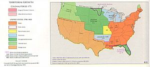
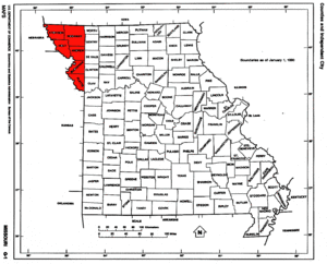
The Platte Purchase was a big land deal in 1836. The United States government bought this land from several American Indian tribes. It was located along the east side of the Missouri River. This purchase added about 3,149 square miles (8,156 km²) to the northwest corner of the state of Missouri.
This new land made Missouri, which was a "slave state," even bigger. This went against a rule called the Missouri Compromise of 1820. That rule said slavery could not spread into new territories north of a certain line (36°30′ north latitude). Missouri was an exception, but this new land was outside its original borders. The Platte Purchase area was almost as big as the states of Delaware and Rhode Island put together! It stretched Missouri further west along the river. The city of St. Joseph, an important river port for pioneers heading west, was in this new land.
Today, the Platte Purchase area includes several counties in Missouri. These are Andrew, Atchison, Buchanan, Holt, Nodaway, and Platte. It also covers parts of Kansas City, the cities of St. Joseph and Maryville, Missouri, and Kansas City International Airport.
How the Land Was Bought
When Missouri first became a state, its western border was a straight line. This line went north from where the Kansas River flows into the Missouri River. But this border wasn't very clear, and people started moving onto land that still belonged to Native American tribes. For example, Joseph Robidoux IV had a fur trading post in what is now St. Joseph, Missouri since 1826.
In 1835, a senator named Lewis F. Linn asked about buying this land. An Indian agent named John Dougherty agreed. He noted that the land was blocking Missouri residents from using the Missouri River for shipping.
The first tribe to agree to give up their land was the Potawatomi. They signed the Treaty of Chicago in 1833, which was finalized in 1835. About 1,000 to 2,000 Potawatomi people moved north to a reservation in Pottawattamie County, Iowa. Later, they were forced to move again in 1837–1838 to Osawatomie, Kansas. This difficult journey is known as the Potawatomi Trail of Death.
In the summer of 1835, Missouri residents formally asked Congress to buy the land. Senator Thomas Hart Benton then introduced a bill to acquire it. Congress approved this bill in June 1836.
An agreement was made on September 17, 1836. Chiefs Mahaska and No Heart of the Ioway tribe, along with leaders of the Sac and Fox tribes, met at Fort Leavenworth. William Clark, who was famous for the Lewis and Clark Expedition, oversaw the meeting.
The United States Senate approved the treaty in February 1837. President Martin Van Buren officially supported the purchase in March 1837. In October 1837, Missouri accepted the land and added it to the newly created Platte County.
This purchase made Missouri even larger. It also challenged the Missouri Compromise because it expanded slavery into new territory. It also meant that tribes who had just been moved west of Missouri were forced to move again. The tribes were paid $7,500 for their land. The U.S. government also promised to give them farming tools, livestock, and other items. They also agreed to build houses, fence land, and provide a farmer, blacksmith, teacher, and interpreter for each tribe. The tribes moved to reservations in what is now Kansas and Nebraska. These are known today as the Ioway Reservation and the Sac and Fox Reservation.
Settling the New Land
The U.S. Government set up an office in Plattsburg, Missouri to manage the settlement of the new land. Much of the land was given out as "military land warrants." These were like special tickets for land given to veterans of the War of 1812 and later the Mexican–American War. These land grants could even be sold by veterans or their families.
At first, many settlers moved to the Town of Barry in southern Platte County. Platte County quickly became the second-largest county in Missouri. Weston, Missouri became the second-largest city in the state after St. Louis. Later, St. Joseph also grew to be a very important city.
Since the Platte Purchase opened up new areas for slavery, many of the settlers came from southern states like Virginia, Tennessee, and Kentucky. They brought enslaved African Americans with them or bought them at slave markets. These enslaved people were forced to work on farms growing crops like hemp and tobacco. These crops needed a lot of labor. Farms in the southern part of the purchase had good access to the Missouri River for shipping their goods. The northern part of the purchase attracted fewer slaveholders.
Today, the Platte Purchase area is mostly rural. St. Joseph and Maryville, Missouri are the only cities completely within the purchase area with populations over 10,000. Kansas City, Missouri has grown and now includes parts of southern Platte County.
 | Lonnie Johnson |
 | Granville Woods |
 | Lewis Howard Latimer |
 | James West |


