
Andrew County, Missouri facts for kids
Quick facts for kids
Andrew County
|
|
|---|---|

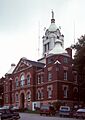
Andrew County Courthouse
|
|

Location within the U.S. state of Missouri
|
|
 Missouri's location within the U.S. |
|
| Country | |
| State | |
| Founded | January 29, 1841 |
| Named for | Andrew Jackson Davis |
| Seat | Savannah |
| Largest city | Savannah |
| Area | |
| • Total | 436 sq mi (1,130 km2) |
| • Land | 433 sq mi (1,120 km2) |
| • Water | 3.7 sq mi (10 km2) 0.9% |
| Population
(2020)
|
|
| • Total | 18,135 |
| • Density | 41.59/sq mi (16.060/km2) |
| Time zone | UTC−6 (Central) |
| • Summer (DST) | UTC−5 (CDT) |
| Congressional district | 6th |
Andrew County is a county located in the northwestern part of the U.S. state of Missouri. As of the 2020 census, about 18,135 people live here. Its main town, or county seat, is Savannah. The county was created on January 29, 1841. It was named after Andrew Jackson Davis, who was a lawyer and an important person from St. Louis.
Andrew County is part of the larger St. Joseph, MO–KS Metropolitan Statistical Area. This area is also included in the even larger Kansas City, MO–KS Combined statistical area.
Contents
History of Andrew County
Andrew County was formed in 1841. It is one of six counties in the Platte Purchase Territory. This land was added to Missouri in 1837. The county is named after Andrew Jackson Davis, who was a newspaper editor in St. Louis. The first settlers arrived in the mid-1830s. They came from states like Ohio, Indiana, Tennessee, Kentucky, Virginia, and other parts of Missouri.
Savannah, the county seat, was planned in 1841. It was first called Union, but then renamed after Savannah, Georgia. A railroad reached Savannah in 1860, helping the town grow as a place for shipping goods and trading after the Civil War.
Andrew County during the Civil War
During the American Civil War, people in Andrew County had different ideas. Some supported the Union (the North), and others supported the Confederacy (the South). In August 1861, about 1,500 soldiers from Andrew County and nearby areas joined the pro-Southern Missouri State Guard. Other people joined a large Union camp in a neighboring county.
Newspapers in Savannah also showed this divide. In 1861, Union troops took over a pro-Southern newspaper. Later, pro-Southern troops took over a Union newspaper. Groups of fighters known as guerrillas moved through the county until 1863.
Land and Rivers
Andrew County has flat, fertile land that is good for raising livestock, growing grains, and fruit farms. The One Hundred and Two River and the Platte River flow through the county. The Nodaway and Missouri rivers form its western border.
In 1804, the famous Lewis and Clark Expedition camped on an island at the mouth of the Nodaway River. Later, in 1811, members of fur trader W. Price Hunt's expedition also spent the winter near the mouth of the river.
Early Towns
Many towns were founded in Andrew County over the years:
- Amazonia was started in 1857. It used to be on the Missouri River but is now further inland.
- Fillmore was established in 1845.
- Whitesville was established in 1848.
- Rochester was established in 1848.
- Bolckow was established in 1868.
- Rosendale was established in 1869.
- Rea was established in 1877.
- Helena was established in 1878.
- Cosby was established in 1882.
Andrew County Museum
The Andrew County Museum & Historical Society helps people learn about the county's past. They have exhibits, programs, and publications. The museum collects and takes care of old documents and items. Their goal is to help everyone appreciate and preserve the history of Andrew County.
Geography
Andrew County covers a total area of about 436 square miles (1,130 km²). Most of this area, 433 square miles (1,120 km²), is land. Only about 3.7 square miles (9.6 km²), or 0.9%, is water.
Neighboring Counties
Andrew County shares borders with these counties:
- Nodaway County (north)
- Gentry County (northeast)
- DeKalb County (east)
- Buchanan County (south)
- Doniphan County, Kansas (southwest)
- Holt County (west)
Main Roads
Several important highways pass through Andrew County:
 Interstate 29
 Interstate 229
 U.S. Route 59
 U.S. Route 71
 U.S. Route 169
 Route 48
Population Data
| Historical population | |||
|---|---|---|---|
| Census | Pop. | %± | |
| 1850 | 9,433 | — | |
| 1860 | 11,850 | 25.6% | |
| 1870 | 15,137 | 27.7% | |
| 1880 | 16,318 | 7.8% | |
| 1890 | 16,000 | −1.9% | |
| 1900 | 17,332 | 8.3% | |
| 1910 | 15,282 | −11.8% | |
| 1920 | 14,075 | −7.9% | |
| 1930 | 13,469 | −4.3% | |
| 1940 | 13,015 | −3.4% | |
| 1950 | 11,727 | −9.9% | |
| 1960 | 11,062 | −5.7% | |
| 1970 | 11,913 | 7.7% | |
| 1980 | 13,908 | 16.7% | |
| 1990 | 14,632 | 5.2% | |
| 2000 | 16,492 | 12.7% | |
| 2010 | 17,291 | 4.8% | |
| 2020 | 18,135 | 4.9% | |
| U.S. Decennial Census 1790-1960 1900-1990 1990-2000 2010-2015 |
|||
In 2000, there were 16,492 people living in Andrew County. The population density was about 38 people per square mile. Most people in the county (98.38%) were White. About 0.84% of the population were Hispanic or Latino.
The median age in the county was 38 years old. This means half the people were younger than 38, and half were older.
2020 Census Information
| Race | Number | Percent |
|---|---|---|
| White (Not Hispanic) | 16,756 | 92.4% |
| Black or African American (Not Hispanic) | 138 | 0.8% |
| Native American (Not Hispanic) | 40 | 0.2% |
| Asian (Not Hispanic) | 89 | 0.5% |
| Pacific Islander (Not Hispanic) | 0 | 0% |
| Other/Mixed (Not Hispanic) | 721 | 4% |
| Hispanic or Latino | 391 | 2.2% |
Religion
Andrew County is sometimes seen as being on the northern edge of the "Bible Belt." This means that many people in the area follow evangelical Protestant religions. The most common religious groups in Andrew County are Southern Baptists, United Methodists, and Disciples of Christ.
Education
Andrew County has several public school districts and a public library system.
Public Schools
- Avenue City R-IX School District – located in Cosby
- Avenue City Elementary School (Grades PK-8)
- North Andrew County R-VI School District – located in Rosendale
- North Andrew County Elementary School (Grades K-5)
- North Andrew County Middle School (Grades 6-8)
- North Andrew County High School (Grades 9-12)
- Savannah R-III School District – located in Savannah
- Savannah Early Learning Center (Preschool)
- Amazonia Elementary School (Grades K-5)
- Helena Elementary School (Grades K-5)
- John Glenn Elementary School (Grades K-5)
- Minnie Cline Elementary School (Grades K-5)
- Savannah Middle School (Grades 6-8)
- Savannah High School (Grades 9-12)
Public Libraries
- Rolling Hills Consolidated Library—Savannah Branch
Communities
Andrew County has several cities, villages, and unincorporated communities.
Cities
- Bolckow
- Fillmore
- Rea
- Rosendale
- Savannah (the county seat)
- St. Joseph (a small part of this city is in Andrew County)
Villages
Unincorporated Communities
Townships
Andrew County is divided into 10 areas called townships:
- Benton
- Clay
- Empire
- Jackson
- Jefferson
- Lincoln
- Monroe
- Nodaway
- Platte
- Rochester
Notable People
Many interesting people have connections to Andrew County:
- Nellie Tayloe Ross was the first female Governor of Wyoming (1925-1927). She was also the first woman elected as a governor in any U.S. state. Later, she became the first female director of the U.S. Mint.
- Joseph K. Toole (1851-1929) was the very first Governor of Montana.
- John P. Altgeld, who was the Governor of Illinois from 1893 to 1897, lived in Savannah.
- Eminem, a famous American rapper, lived in Savannah and went to middle school there.
Images for kids
-
Andrew County Courthouse
See also
 In Spanish: Condado de Andrew para niños
