
One Hundred and Two River facts for kids
The One Hundred and Two River is a cool waterway in northwestern Missouri, United States. It's a tributary (which means it's a smaller river that flows into a bigger one) of the Platte River. This river starts with smaller streams in southwestern Iowa and flows for about 80 miles (129 km) before joining the Platte.
The Platte River then flows into the mighty Missouri River. So, the One Hundred and Two River is part of the huge area of land (called a watershed) that drains into the Missouri River. Over time, much of this river has been made straighter and deeper by people, a process called channelization.
You might hear this river called a few different names! Sometimes it's known as the Hundred and Two River, or even just the 102 River. It officially begins where three smaller rivers meet: the East Fork, Middle Fork, and West Fork One Hundred and Two River. These three forks all start in Iowa.
Contents
Why is it Called the One Hundred and Two River?
Have you ever wondered how the One Hundred and Two River got its unique name? It's a bit of a mystery, but the most likely reason has to do with old land surveys!
The Sullivan Line Connection
The border between Missouri and Iowa is called the Sullivan Line. This line starts about 100 miles (161 km) north of where the Missouri River and Kansas River meet in Kansas City, Missouri.
In the early 1800s, this line was used as a starting point for surveying land in western Missouri. The One Hundred and Two River flows entirely within an area called the Platte Purchase. This was land bought by the U.S. government from Native American tribes in 1836 and added to Missouri. The three forks of the river cross the Sullivan Line at points that are between 101 and 102 miles (163 and 164 km) north of the Kansas-Missouri River meeting point. This makes the "102" in its name a direct reference to its location on these old maps!
Other Ideas for the Name
Over the years, some people have come up with other fun ideas about how the river got its name:
- The Mormon Trail Story: A writer named Homer Croy thought the name might be linked to the Mormon Trail. He suggested that the river was 102 miles (164 km) from a previous camp for pioneers, or that Brigham Young told his followers it was the 102nd river they had crossed since leaving Nauvoo. However, these distances don't quite match up with historical records.
- The French and Osage Idea: Another expert, Robert L. Ramsay, thought the name might be an English translation of an older French name, Rivière Cent Deux. He even wondered if that French name came from an Osage word, Çondse, which means 'Upland Forest'. But the Osage people usually lived much further south than this river.
So, while the other stories are interesting, the most accepted reason for the name is its distance from that important survey point!
Where the River Starts and Flows
The One Hundred and Two River actually begins as three separate streams, or "forks," all starting in Iowa.
The West Fork
The West Fork One Hundred and Two River starts near Corning in Adams County. It flows south through Taylor County, picking up smaller streams along the way.
The Middle Fork
The Middle Fork One Hundred and Two River begins near Sharpsburg in Taylor County. It also flows generally south, passing by the town of Gravity.
The East Fork
The East Fork One Hundred and Two River rises near Lenox in Taylor County. It flows southwest, going past the towns of Conway and Bedford.
Joining Together and Flowing South
All three of these forks eventually enter Nodaway County, Missouri from Iowa. They meet and join together near the town of Hopkins. From this meeting point (called a confluence), the One Hundred and Two River flows south.
It travels through Nodaway, Andrew, and Buchanan Counties. Along its path, it passes by towns like Arkoe, Barnard, Maryville, and Rosendale. As mentioned before, much of its path has been straightened by people. Finally, the One Hundred and Two River joins the Platte River about 6 miles (9.7 km) east of St. Joseph.
Images for kids
-
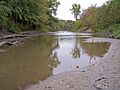
The One Hundred and Two River near Savannah, Missouri, in 2006
-
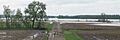
One Hundred and Two River east of Maryville, Missouri during May 2007 flood. The river itself is on the extreme right. Most of the water in the photo is from the flood.
-
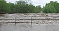
One Hundred and Two River after breaching dam at Maryville during May 2007 flood.
-
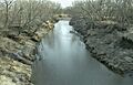
The East Fork of the One Hundred and Two River near Bedford, Iowa, in 1997


