Rosendale, Missouri facts for kids
Quick facts for kids
Rosendale, Missouri
|
|
|---|---|
 |
|

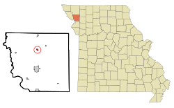
Location of Rosendale, Missouri
|
|
| Country | United States |
| State | Missouri |
| County | Andrew |
| Area | |
| • Total | 0.30 sq mi (0.79 km2) |
| • Land | 0.29 sq mi (0.76 km2) |
| • Water | 0.01 sq mi (0.03 km2) |
| Elevation | 919 ft (280 m) |
| Population
(2020)
|
|
| • Total | 119 |
| • Density | 406.14/sq mi (156.86/km2) |
| Time zone | UTC-6 (Central (CST)) |
| • Summer (DST) | UTC-5 (CDT) |
| ZIP code |
64483
|
| Area code(s) | 816 |
| FIPS code | 29-63200 |
| GNIS feature ID | 2396434 |
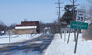
Rosendale is a small city located in Andrew County, Missouri, in the United States. It's a quiet place with a friendly community. According to the 2020 census, about 119 people live there.
Rosendale is also part of the larger St. Joseph Metropolitan Area, which includes parts of Missouri and Kansas.
Contents
Exploring Rosendale's Past
How Rosendale Got Its Name
The city of Rosendale has an interesting history! A post office first opened here in 1869, which means people were living and sending mail from this area a long time ago. The city was named "Rosendale" because there were many wild roses growing near where the town was first built. Imagine a field full of beautiful roses!
Understanding Rosendale's Location
Where is Rosendale Located?
Rosendale is situated on the east side of the One Hundred and Two River. This river is a natural feature that helps define the city's landscape.
How Big is Rosendale?
The United States Census Bureau tells us that Rosendale covers a total area of about 0.30 square miles (or 0.79 square kilometers). Most of this area is land, about 0.29 square miles (0.76 square kilometers). A very small part, about 0.01 square miles (0.03 square kilometers), is water.
People of Rosendale
How Many People Live in Rosendale?
The number of people living in Rosendale has changed over the years. Here's a look at the population counts from different census years:
| Historical population | |||
|---|---|---|---|
| Census | Pop. | %± | |
| 1880 | 128 | — | |
| 1890 | 288 | 125.0% | |
| 1900 | 448 | 55.6% | |
| 1910 | 359 | −19.9% | |
| 1920 | 329 | −8.4% | |
| 1930 | 322 | −2.1% | |
| 1940 | 300 | −6.8% | |
| 1950 | 245 | −18.3% | |
| 1960 | 234 | −4.5% | |
| 1970 | 245 | 4.7% | |
| 1980 | 223 | −9.0% | |
| 1990 | 186 | −16.6% | |
| 2000 | 180 | −3.2% | |
| 2010 | 143 | −20.6% | |
| 2020 | 119 | −16.8% | |
| U.S. Decennial Census | |||
What the 2010 Census Showed
In 2010, there were 143 people living in Rosendale. These people lived in 50 different homes, and 38 of those homes were families. The city had about 493 people per square mile.
Most of the people in Rosendale were White (98.6%). A small number were Native American (0.7%) or from other backgrounds (0.7%). About 0.7% of the people were of Hispanic or Latino heritage.
The average age of people in Rosendale in 2010 was about 32.8 years old. About 31.5% of the residents were under 18 years old, and 11.9% were 65 years or older. There were slightly more males (54.5%) than females (45.5%) in the city.
See also
 In Spanish: Rosendale (Misuri) para niños
 | Georgia Louise Harris Brown |
 | Julian Abele |
 | Norma Merrick Sklarek |
 | William Sidney Pittman |

