Doniphan County, Kansas facts for kids
Quick facts for kids
Doniphan County
|
|
|---|---|

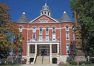
Doniphan County Courthouse in Troy (2006)
|
|

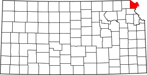
Location within the U.S. state of Kansas
|
|
 Kansas's location within the U.S. |
|
| Country | |
| State | |
| Founded | August 25, 1855 |
| Named for | Alexander William Doniphan |
| Seat | Troy |
| Largest city | Wathena |
| Area | |
| • Total | 398 sq mi (1,030 km2) |
| • Land | 393 sq mi (1,020 km2) |
| • Water | 4.9 sq mi (13 km2) 1.2%% |
| Population
(2020)
|
|
| • Total | 7,510 |
| • Density | 19.1/sq mi (7.4/km2) |
| Time zone | UTC−6 (Central) |
| • Summer (DST) | UTC−5 (CDT) |
| Area code | 785 |
| Congressional district | 2nd |
Doniphan County is a county located in the northeastern part of Kansas, a state in the United States. It's the county that is furthest to the northeast in Kansas. The main town, or county seat, is Troy. The biggest city in the county is Wathena.
In 2020, about 7,510 people lived here. Doniphan County was named after Alexander William Doniphan, who was a hero in the Mexican-American War. The county is bordered by the Missouri River to the east. To the south is Atchison County, and to the west is Brown County.
Contents
Exploring Doniphan County's Past
How Doniphan County Began
For thousands of years, the Great Plains of North America were home to nomadic Native American tribes. In the 16th to 18th centuries, France claimed large areas of North America. In 1762, after a war, France secretly gave this land to Spain.
Later, in 1802, Spain returned most of the land to France. Then, in 1803, the United States bought a huge amount of land from France. This was part of the Louisiana Purchase. Most of what is now Kansas was included in this deal.
Becoming a County
The Kansas Territory was set up in 1854. Kansas officially became the 34th U.S. state in 1861. Doniphan County was created on August 25, 1855. It was named after Colonel Alexander William Doniphan. He was a U.S. cavalry leader who played an important role in the Mexican–American War.
Geography and Nature
Doniphan County is in the very northeast corner of Kansas. It shares borders with Nebraska to the north and Missouri to the east. The county covers about 398 square miles. Most of this is land (393 square miles), and a small part is water (4.9 square miles). It is one of the smallest counties in Kansas.
Rivers and Water Sources
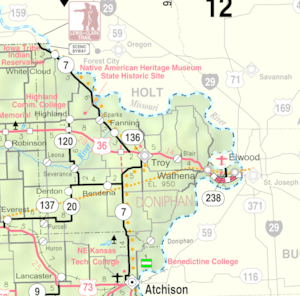
The Missouri River forms the border on the north and east sides of the county. This river is important for shipping goods. It also provides a lot of water for the eastern part of the county. Towns further inland, like Troy and Highland, get their water from underground wells. The Wolf River flows through the western parts of the county.
Main Roads and Travel
The main road in Doniphan County is U.S. Highway 36. This highway goes from east to west. It passes through towns like Troy, Elwood, and Wathena. Other state highways like K-7 and K-20 serve other areas. K-7 is even known as a scenic byway because of its beautiful views.
Neighboring Counties
Doniphan County is surrounded by several other counties:
- Holt County, Missouri (north)
- Andrew County, Missouri (northeast)
- Buchanan County, Missouri (southeast)
- Atchison County (southwest)
- Brown County (west)
- Richardson County, Nebraska (northwest)
People and Population

| Historical population | |||
|---|---|---|---|
| Census | Pop. | %± | |
| 1860 | 8,083 | — | |
| 1870 | 13,969 | 72.8% | |
| 1880 | 14,257 | 2.1% | |
| 1890 | 13,535 | −5.1% | |
| 1900 | 15,079 | 11.4% | |
| 1910 | 14,422 | −4.4% | |
| 1920 | 13,438 | −6.8% | |
| 1930 | 14,063 | 4.7% | |
| 1940 | 12,936 | −8.0% | |
| 1950 | 10,499 | −18.8% | |
| 1960 | 9,574 | −8.8% | |
| 1970 | 9,107 | −4.9% | |
| 1980 | 9,268 | 1.8% | |
| 1990 | 8,134 | −12.2% | |
| 2000 | 8,249 | 1.4% | |
| 2010 | 7,945 | −3.7% | |
| 2020 | 7,510 | −5.5% | |
| 2023 (est.) | 7,493 | −5.7% | |
| U.S. Decennial Census 1790-1960 1900-1990 1990-2000 2010-2020 |
|||
Doniphan County is part of the larger St. Joseph, Missouri-Kansas metropolitan area. This means it's connected to the economy and community of the nearby city of St. Joseph.
Learning and Education
Local Schools
Doniphan County has several school districts that serve its communities:
- Doniphan West USD 111
- Riverside USD 114
- Troy USD 429
Colleges in the Area
Highland Community College was the first college ever started in Kansas! It began in 1858 as Highland University. Over the years, it changed its name and became a regional community college. You can visit their website to learn more: highlandcc.edu.
Towns and Communities
Here's a list of the different types of communities you can find in Doniphan County.
Cities in Doniphan County
Smaller Communities (Unincorporated)
These are smaller places that don't have their own city government. Some are called Census-Designated Places (CDP) by the U.S. Census Bureau.
Ghost Towns
- Geary (A town that no longer exists)
Native American Reservations
- Ioway Reservation‡ (Parts of this reservation are also in a neighboring county.)
Fun Places to Visit
Doniphan County has some interesting spots to explore:
- Native American Heritage Museum: Located near Highland, this museum was once a mission built in 1845. It taught children from the Iowa and Missouri Sac and Fox tribes. Today, it shows off the art and history of the Native American tribes who moved to northeastern Kansas. You can find out more here: kshs.org/places/nativeamerican.
- Nelson Rodgers House: In Troy, this house was built in 1856. It's the first and oldest house still standing in Troy, made from hand-cut timbers.
- Four-state Lookout: Head to White Cloud for this amazing viewing platform. From here, you can see a wide view of the Missouri River valley. You might even be able to see parts of Kansas, Missouri, Nebraska, and possibly Iowa!
- Townsite of Old Doniphan: On July 4, 1804, the famous Lewis and Clark Expedition camped near an old Kanza Indian village. This is where the former town of Doniphan was later established.
See also
 In Spanish: Condado de Doniphan para niños
 | William Lucy |
 | Charles Hayes |
 | Cleveland Robinson |


