Troy, Kansas facts for kids
Quick facts for kids
Troy, Kansas
|
|
|---|---|
|
City and County seat
|
|

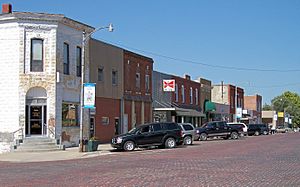
Troy business district with brick street (2006)
|
|

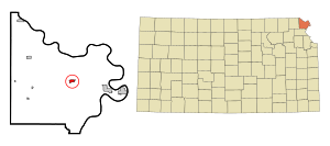
Location within Doniphan County and Kansas
|
|

|
|
| Country | United States |
| State | Kansas |
| County | Doniphan |
| Founded | 1855 |
| Incorporated | 1860 |
| Named for | Troy |
| Government | |
| • Type | Mayor–Council |
| Area | |
| • Total | 0.98 sq mi (2.54 km2) |
| • Land | 0.97 sq mi (2.52 km2) |
| • Water | 0.01 sq mi (0.02 km2) |
| Elevation | 1,089 ft (332 m) |
| Population
(2020)
|
|
| • Total | 964 |
| • Density | 984/sq mi (379.5/km2) |
| Time zone | UTC-6 (CST) |
| • Summer (DST) | UTC-5 (CDT) |
| ZIP code |
66087
|
| Area code | 785 |
| FIPS code | 20-71575 |
| GNIS ID | 2397063 |
Troy is a city located in Doniphan County, Kansas, in the United States. It is the main city, also known as the county seat, for Doniphan County. In 2020, about 964 people lived there.
Contents
History of Troy
Troy was planned out in 1855. It got its name from the ancient city of Troy. The first house in Troy was built in 1856. A year later, in 1857, the first store opened. Troy officially became a city in 1860. The first post office started in March 1857.
Troy began as a small stop along a wagon route. This route went from St. Joseph, Missouri all the way to Oregon and California. In 1860, an explorer named Richard Francis Burton passed through. He described Troy as "a few wretched shanties."
Geography and Climate
Troy is a small city. It covers about 0.99 square miles (2.56 square kilometers) in total. Most of this area, about 0.98 square miles (2.54 square kilometers), is land. Only a tiny part, 0.01 square miles (0.02 square kilometers), is water.
Troy's Weather
| Climate data for Troy 3N, Kansas (1991–2020 normals, extremes 1950–present) | |||||||||||||
|---|---|---|---|---|---|---|---|---|---|---|---|---|---|
| Month | Jan | Feb | Mar | Apr | May | Jun | Jul | Aug | Sep | Oct | Nov | Dec | Year |
| Record high °F (°C) | 73 (23) |
79 (26) |
89 (32) |
94 (34) |
97 (36) |
103 (39) |
106 (41) |
106 (41) |
103 (39) |
95 (35) |
83 (28) |
72 (22) |
106 (41) |
| Mean maximum °F (°C) | 60.6 (15.9) |
65.3 (18.5) |
77.4 (25.2) |
84.6 (29.2) |
88.7 (31.5) |
92.6 (33.7) |
96.3 (35.7) |
95.8 (35.4) |
91.6 (33.1) |
85.7 (29.8) |
72.7 (22.6) |
63.0 (17.2) |
97.6 (36.4) |
| Mean daily maximum °F (°C) | 36.0 (2.2) |
41.5 (5.3) |
53.7 (12.1) |
64.5 (18.1) |
74.2 (23.4) |
82.9 (28.3) |
86.7 (30.4) |
85.4 (29.7) |
78.7 (25.9) |
67.0 (19.4) |
52.5 (11.4) |
40.0 (4.4) |
63.6 (17.6) |
| Daily mean °F (°C) | 26.5 (−3.1) |
31.2 (−0.4) |
42.5 (5.8) |
53.0 (11.7) |
63.6 (17.6) |
72.9 (22.7) |
76.9 (24.9) |
74.9 (23.8) |
67.3 (19.6) |
55.4 (13.0) |
42.2 (5.7) |
31.0 (−0.6) |
53.1 (11.7) |
| Mean daily minimum °F (°C) | 17.0 (−8.3) |
20.9 (−6.2) |
31.2 (−0.4) |
41.6 (5.3) |
53.1 (11.7) |
63.0 (17.2) |
67.0 (19.4) |
64.5 (18.1) |
55.9 (13.3) |
43.8 (6.6) |
31.8 (−0.1) |
22.0 (−5.6) |
42.6 (5.9) |
| Mean minimum °F (°C) | −5.0 (−20.6) |
1.3 (−17.1) |
10.7 (−11.8) |
25.4 (−3.7) |
38.0 (3.3) |
49.5 (9.7) |
54.8 (12.7) |
52.6 (11.4) |
38.6 (3.7) |
26.0 (−3.3) |
14.4 (−9.8) |
1.8 (−16.8) |
−8.4 (−22.4) |
| Record low °F (°C) | −18 (−28) |
−23 (−31) |
−13 (−25) |
8 (−13) |
26 (−3) |
40 (4) |
45 (7) |
43 (6) |
30 (−1) |
17 (−8) |
−7 (−22) |
−22 (−30) |
−23 (−31) |
| Average precipitation inches (mm) | 0.97 (25) |
1.37 (35) |
2.23 (57) |
3.75 (95) |
5.13 (130) |
4.50 (114) |
5.00 (127) |
3.90 (99) |
3.40 (86) |
3.06 (78) |
1.96 (50) |
1.57 (40) |
36.84 (936) |
| Average snowfall inches (cm) | 5.5 (14) |
5.9 (15) |
2.2 (5.6) |
0.8 (2.0) |
0.1 (0.25) |
0.0 (0.0) |
0.0 (0.0) |
0.0 (0.0) |
0.0 (0.0) |
0.3 (0.76) |
1.3 (3.3) |
5.0 (13) |
21.1 (54) |
| Average precipitation days (≥ 0.01 in) | 6.6 | 6.4 | 8.8 | 10.5 | 11.5 | 10.3 | 9.4 | 8.6 | 8.0 | 8.2 | 6.2 | 6.4 | 100.9 |
| Average snowy days (≥ 0.1 in) | 3.7 | 3.2 | 1.7 | 0.5 | 0.0 | 0.0 | 0.0 | 0.0 | 0.0 | 0.2 | 0.8 | 3.1 | 13.2 |
| Source: NOAA | |||||||||||||
People of Troy
| Historical population | |||
|---|---|---|---|
| Census | Pop. | %± | |
| 1860 | 131 | — | |
| 1870 | 639 | 387.8% | |
| 1880 | 694 | 8.6% | |
| 1890 | 730 | 5.2% | |
| 1900 | 750 | 2.7% | |
| 1910 | 940 | 25.3% | |
| 1920 | 1,013 | 7.8% | |
| 1930 | 1,042 | 2.9% | |
| 1940 | 1,049 | 0.7% | |
| 1950 | 977 | −6.9% | |
| 1960 | 1,051 | 7.6% | |
| 1970 | 1,047 | −0.4% | |
| 1980 | 1,240 | 18.4% | |
| 1990 | 1,073 | −13.5% | |
| 2000 | 1,054 | −1.8% | |
| 2010 | 1,010 | −4.2% | |
| 2020 | 964 | −4.6% | |
| U.S. Decennial Census | |||
Troy's Population in 2020
In 2020, the city of Troy had 964 people living in 375 homes. Most people, about 94.2%, were White. A small number were African American (0.6%), Native American (0.2%), or Asian (0.3%). About 4% of the people were of two or more races. People of Hispanic or Latino background made up 2.4% of the population.
About 22.6% of homes had children under 18 living there. The average age in Troy was 44.2 years. About 22.6% of residents were under 18. Also, 13.9% were 65 years old or older. The population was almost evenly split between males (52.8%) and females (57.2%).
Troy's Population in 2010
In 2010, Troy had 1,010 people living in 421 homes. The city had about 1030.6 people per square mile. There were 467 housing units. Most people (97.3%) were White. About 2.7% of the population was Hispanic or Latino.
In 2010, 31.4% of homes had children under 18. About half of the homes (49.6%) were married couples. The average age in Troy was 39.1 years. About 24.7% of residents were under 18. Also, 17.3% were 65 years old or older. The city had slightly more females (51.7%) than males (48.3%).
Education in Troy
The public schools in Troy are part of the Troy USD 429 school district. This district serves the children in the community.
Famous People from Troy
- Chloe Gartner was an American writer.
- Charles "Buffalo" Jones was a frontiersman and conservationist. He helped start Garden City, Kansas.
- Charles Evans Whittaker was a Supreme Court Justice. He served from 1957 to 1962.
See also
 In Spanish: Troy (Kansas) para niños
 | Valerie Thomas |
 | Frederick McKinley Jones |
 | George Edward Alcorn Jr. |
 | Thomas Mensah |


