Elwood, Kansas facts for kids
Quick facts for kids
Elwood, Kansas
|
|
|---|---|

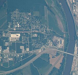
Elwood on July 4, 2022, taken from the International Space Station
|
|

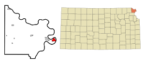
Location within Doniphan County and Kansas
|
|

|
|
| Country | United States |
| State | Kansas |
| County | Doniphan |
| Founded | 1856 |
| Incorporated | 1860 |
| Named for | John Elwood |
| Area | |
| • Total | 2.91 sq mi (7.54 km2) |
| • Land | 2.91 sq mi (7.54 km2) |
| • Water | 0.00 sq mi (0.00 km2) |
| Elevation | 817 ft (249 m) |
| Population
(2020)
|
|
| • Total | 1,125 |
| • Density | 386.6/sq mi (149.20/km2) |
| Time zone | UTC-6 (CST) |
| • Summer (DST) | UTC-5 (CDT) |
| ZIP code |
66024
|
| Area code | 913 |
| FIPS code | 20-20950 |
| GNIS ID | 2394681 |
Elwood is a small city in Doniphan County, Kansas, United States. It is located on the west side of the Missouri River, right across from Saint Joseph, Missouri. In 2020, about 1,125 people lived in Elwood.
Contents
History of Elwood
For thousands of years, the Great Plains of North America were home to nomadic Native American tribes. These groups moved around to hunt and gather food.
In 1854, the area became the Kansas Territory under a law called the Kansas–Nebraska Act. This act allowed people living there to decide if they wanted slavery or not. In 1861, Kansas officially became the 34th U.S. state. The county where Elwood is located, Doniphan County, was created in 1855.
Founding of the City
The story of Elwood began in 1852 when a trading post was set up in the area. A trading post was like a small store where people could trade goods. In 1856, the land was sold, and the town of Elwood was planned out.
The city was named after John B. Elwood, who was one of the first settlers in the area. Elwood officially became a city in 1860. The first post office in Elwood opened its doors in June 1857, making it easier for people to send and receive mail.
Geography and Climate
Elwood covers an area of about 3.20 square miles (8.29 square kilometers). All of this area is land, with no large bodies of water within the city limits.
Elwood's Weather
| Climate data for Elwood, Kansas (Rosecrans Memorial Airport, Missouri) 1991–2020 normals, extremes 1908–present | |||||||||||||
|---|---|---|---|---|---|---|---|---|---|---|---|---|---|
| Month | Jan | Feb | Mar | Apr | May | Jun | Jul | Aug | Sep | Oct | Nov | Dec | Year |
| Record high °F (°C) | 73 (23) |
83 (28) |
98 (37) |
96 (36) |
103 (39) |
105 (41) |
108 (42) |
110 (43) |
107 (42) |
97 (36) |
82 (28) |
73 (23) |
110 (43) |
| Mean maximum °F (°C) | 62 (17) |
65 (18) |
79 (26) |
87 (31) |
92 (33) |
95 (35) |
97 (36) |
97 (36) |
92 (33) |
88 (31) |
75 (24) |
64 (18) |
99 (37) |
| Mean daily maximum °F (°C) | 37.4 (3.0) |
42.8 (6.0) |
55.1 (12.8) |
65.9 (18.8) |
75.8 (24.3) |
84.7 (29.3) |
88.1 (31.2) |
86.2 (30.1) |
79.7 (26.5) |
67.8 (19.9) |
53.4 (11.9) |
41.1 (5.1) |
64.8 (18.2) |
| Daily mean °F (°C) | 27.3 (−2.6) |
32.0 (0.0) |
43.3 (6.3) |
53.8 (12.1) |
64.8 (18.2) |
74.2 (23.4) |
77.7 (25.4) |
75.3 (24.1) |
67.0 (19.4) |
55.3 (12.9) |
42.0 (5.6) |
31.1 (−0.5) |
53.6 (12.0) |
| Mean daily minimum °F (°C) | 17.1 (−8.3) |
21.2 (−6.0) |
31.5 (−0.3) |
41.8 (5.4) |
53.7 (12.1) |
63.8 (17.7) |
67.3 (19.6) |
64.5 (18.1) |
54.4 (12.4) |
42.8 (6.0) |
30.6 (−0.8) |
21.1 (−6.1) |
42.5 (5.8) |
| Mean minimum °F (°C) | −5 (−21) |
3 (−16) |
12 (−11) |
25 (−4) |
38 (3) |
51 (11) |
56 (13) |
52 (11) |
39 (4) |
25 (−4) |
14 (−10) |
1 (−17) |
−9 (−23) |
| Record low °F (°C) | −25 (−32) |
−23 (−31) |
−13 (−25) |
2 (−17) |
29 (−2) |
41 (5) |
41 (5) |
41 (5) |
30 (−1) |
11 (−12) |
−5 (−21) |
−24 (−31) |
−25 (−32) |
| Average precipitation inches (mm) | 0.71 (18) |
0.95 (24) |
2.06 (52) |
3.71 (94) |
4.87 (124) |
4.75 (121) |
4.73 (120) |
3.84 (98) |
3.18 (81) |
2.84 (72) |
1.87 (47) |
1.25 (32) |
34.76 (883) |
| Average precipitation days (≥ 0.01 in) | 4.7 | 5.6 | 7.7 | 10.6 | 12.3 | 11.8 | 9.3 | 9.4 | 8.4 | 8.3 | 5.6 | 5.6 | 99.3 |
| Source: NOAA | |||||||||||||
People of Elwood
| Historical population | |||
|---|---|---|---|
| Census | Pop. | %± | |
| 1880 | 323 | — | |
| 1890 | 377 | 16.7% | |
| 1900 | 623 | 65.3% | |
| 1910 | 636 | 2.1% | |
| 1920 | 750 | 17.9% | |
| 1930 | 849 | 13.2% | |
| 1940 | 1,014 | 19.4% | |
| 1950 | 1,020 | 0.6% | |
| 1960 | 1,191 | 16.8% | |
| 1970 | 1,283 | 7.7% | |
| 1980 | 1,275 | −0.6% | |
| 1990 | 1,079 | −15.4% | |
| 2000 | 1,145 | 6.1% | |
| 2010 | 1,224 | 6.9% | |
| 2020 | 1,125 | −8.1% | |
| U.S. Decennial Census | |||
Elwood is part of the larger St. Joseph, MO–KS Metropolitan Statistical Area. This means it's connected to the economy and community of the nearby city of St. Joseph.
Elwood's Population in 2020
The 2020 United States census counted 1,125 people living in Elwood. There were 441 households, which are groups of people living together in one home. About 282 of these households were families.
The people living in Elwood come from different backgrounds. Most residents are white, but there are also African American, Native American, Asian, and people of two or more races. A small percentage of the population is also Hispanic or Latino.
About 32% of the households in Elwood had children under 18 years old. Many households were married couples, and some were single-parent families. The average household had about 2.4 people. The average age of people in Elwood was about 36 years old.
Education in Elwood
The public schools in Elwood are part of the Riverside USD 114 school district. This district was formed when Elwood schools joined with schools from Wathena. The students at Riverside High School are known as the Cyclones.
Before the schools joined together, Elwood used to have its own high school called Elwood High School. Their mascot was the Elwood Panthers.
See also
 In Spanish: Elwood (Kansas) para niños
 | William Lucy |
 | Charles Hayes |
 | Cleveland Robinson |

