Brown County, Kansas facts for kids
Quick facts for kids
Brown County
|
|
|---|---|

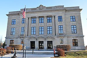
Brown County Courthouse in Hiawatha (2011)
|
|

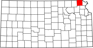
Location within the U.S. state of Kansas
|
|
 Kansas's location within the U.S. |
|
| Country | |
| State | |
| Founded | August 25, 1855 |
| Named for | Albert Gallatin Brown |
| Seat | Hiawatha |
| Largest city | Hiawatha |
| Area | |
| • Total | 572 sq mi (1,480 km2) |
| • Land | 571 sq mi (1,480 km2) |
| • Water | 1.2 sq mi (3 km2) 0.2%% |
| Population
(2020)
|
|
| • Total | 9,508 |
| • Density | 16.7/sq mi (6.4/km2) |
| Time zone | UTC−6 (Central) |
| • Summer (DST) | UTC−5 (CDT) |
| Area code | 785 |
| Congressional district | 2nd |
Brown County is a county located in the northeast part of Kansas. It's like a smaller region within the state. The main city and where the county government is located is Hiawatha. In 2020, about 9,508 people lived here.
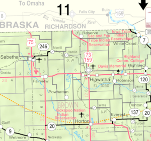
The county was named after Albert G. Brown. He was a U.S. Senator from Mississippi who supported Kansas becoming a state. Brown County is also home to parts of three Native American reservations: the Kickapoo Indian Reservation of Kansas, the Sac and Fox Reservation, and the Iowa Reservation of Kansas and Nebraska.
Contents
History
Early Times
For thousands of years, the Great Plains of North America were home to nomadic Native American tribes. Nomadic means they moved around a lot instead of staying in one place.
From the 1500s to the 1700s, France claimed a lot of land in North America. But in 1762, after a war, France secretly gave a big part of this land to Spain.
The 1800s
In 1802, Spain gave most of that land back to France. Then, in 1803, the United States bought a huge area from France. This was called the Louisiana Purchase. It included most of what is now Kansas. The U.S. paid a very small amount for each acre of land.
In 1854, the Kansas Territory was set up. This was a step before Kansas became a state. Finally, in 1861, Kansas officially became the 34th U.S. state. Brown County itself was created in 1855.
Geography
Brown County covers about 572 square miles. Most of this is land, with only a small amount (about 1.2 square miles) being water. The Wolf River starts in Brown County.
There's also a place called Brown State Fishing Lake in the county. It's a great spot for fishing and used to be known as "Brown County State Park." It's about 8 miles east of Hiawatha.
Neighboring Counties
Brown County shares its borders with several other counties:
- Richardson County, Nebraska (to the north)
- Doniphan County (to the east)
- Atchison County (to the southeast)
- Jackson County (to the southwest)
- Nemaha County (to the west)
Main Roads
Several important roads pass through Brown County, making it easy to travel to and from the area:
- U.S. Route 36
- U.S. Route 73
- U.S. Route 75
- U.S. Route 159
- Kansas Highway 20
- Kansas Highway 246
Population Facts

Here's how the population of Brown County has changed over the years:
| Historical population | |||
|---|---|---|---|
| Census | Pop. | %± | |
| 1860 | 2,607 | — | |
| 1870 | 6,823 | 161.7% | |
| 1880 | 12,817 | 87.8% | |
| 1890 | 20,319 | 58.5% | |
| 1900 | 22,369 | 10.1% | |
| 1910 | 21,314 | −4.7% | |
| 1920 | 20,949 | −1.7% | |
| 1930 | 20,553 | −1.9% | |
| 1940 | 17,395 | −15.4% | |
| 1950 | 14,651 | −15.8% | |
| 1960 | 13,229 | −9.7% | |
| 1970 | 11,685 | −11.7% | |
| 1980 | 11,955 | 2.3% | |
| 1990 | 11,128 | −6.9% | |
| 2000 | 10,724 | −3.6% | |
| 2010 | 9,984 | −6.9% | |
| 2020 | 9,508 | −4.8% | |
| 2023 (est.) | 9,250 | −7.4% | |
| U.S. Decennial Census 1790-1960 1900-1990 1990-2000 2010-2020 |
|||
In 2000, there were 10,724 people living in Brown County. The county had about 19 people per square mile. The average age of people in the county was 40 years old. About 26% of the population was under 18 years old.
Education
Brown County has several school districts that help students learn and grow.
- Local School Districts
- Hiawatha USD 415
- South Brown County USD 430
Some school districts have offices in neighboring counties but also serve parts of Brown County:
- Doniphan West USD 111
- Prairie Hills USD 113
- North Jackson USD 335
There is also a special school connected to the Bureau of Indian Education:
Communities
Brown County has several cities and smaller communities. Some communities are "unincorporated," meaning they don't have their own local government like a city does.
Cities
Here are the cities in Brown County. Some cities marked with a ‡ also have a small part in a county next door.
- Everest
- Fairview
- Hamlin
- Hiawatha (This is the county seat, where the main county offices are)
- Horton
- Morrill
- Powhattan
- Reserve
- Robinson
- Sabetha‡
- Willis
Unincorporated Communities
These are smaller places that are not officially cities. Some marked with a † are called "Census-Designated Places" (CDP) by the U.S. Census Bureau, which means they are recognized for statistics.
- Baker
- Mercier
- Padonia
- Kickapoo Tribal Center†
- Kickapoo Site 1†
- Kickapoo Site 2†
- Kickapoo Site 5†
- Kickapoo Site 6†
- Kickapoo Site 7†
Indian Reservations
Parts of these Native American reservations are located within Brown County. Some marked with a ‡ also extend into other counties.
See also
 In Spanish: Condado de Brown (Kansas) para niños
 | William M. Jackson |
 | Juan E. Gilbert |
 | Neil deGrasse Tyson |


