Nemaha County, Kansas facts for kids
Quick facts for kids
Nemaha County
|
|
|---|---|

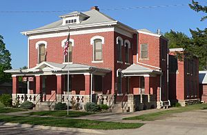
Jail and sheriff residence in Seneca (2015)
|
|

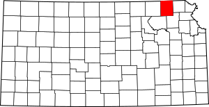
Location within the U.S. state of Kansas
|
|
 Kansas's location within the U.S. |
|
| Country | |
| State | |
| Founded | August 25, 1855 |
| Named for | Nemaha River |
| Seat | Seneca |
| Largest city | Sabetha |
| Area | |
| • Total | 719 sq mi (1,860 km2) |
| • Land | 717 sq mi (1,860 km2) |
| • Water | 2.0 sq mi (5 km2) 0.3%% |
| Population
(2020)
|
|
| • Total | 10,273 |
| • Density | 14.3/sq mi (5.5/km2) |
| Time zone | UTC−6 (Central) |
| • Summer (DST) | UTC−5 (CDT) |
| Area code | 785 |
| Congressional district | 2nd |
Nemaha County is a place in the northeastern part of Kansas, a state in the United States. Its main town, or county seat, is Seneca. In 2020, about 10,273 people lived here. The county got its name from the Nemaha River.
Contents
History of Nemaha County
Early Days and Land Changes
For thousands of years, the Great Plains of North America were home to nomadic Native American tribes. These groups moved around a lot, often following animal herds like buffalo.
From the 1500s to the 1700s, France said it owned large parts of North America. But in 1762, after a big war called the French and Indian War, France secretly gave this land to Spain. This was part of a deal known as the Treaty of Fontainebleau.
How Kansas Became Part of the U.S.
In 1802, Spain gave most of this land back to France. Then, in 1803, the United States bought a huge area from France. This was called the Louisiana Purchase. It included most of what is now Kansas. The U.S. paid a very small amount for each acre!
In 1854, the area became the Kansas Territory. Then, in 1861, Kansas officially became the 34th state in the U.S. Just a few years before, in 1855, Nemaha County was created.
The first railroad in Nemaha County was built in 1866. This helped people travel and move goods more easily.
The Irving Tornado of 1879
On May 30, 1879, a very powerful tornado hit Nemaha County. It was known as the "Irving, Kansas Tornado." This tornado was rated F4 on the Fujita scale, which means it caused incredible damage.
The tornado's path was about 800 yards wide and 100 miles long. Sadly, 18 people lost their lives, and 60 others were hurt. It was a very difficult time for the county.
Geography and Neighboring Areas
Nemaha County covers a total area of about 719 square miles. Most of this area, about 717 square miles, is land. Only a small part, about 2 square miles, is water.
Counties Next to Nemaha County
Nemaha County shares its borders with several other counties:
- Richardson County, Nebraska (to the northeast)
- Brown County (to the east)
- Jackson County (to the southeast)
- Pottawatomie County (to the southwest)
- Marshall County (to the west)
- Pawnee County, Nebraska (to the northwest)
People and Population (Demographics)
| Historical population | |||
|---|---|---|---|
| Census | Pop. | %± | |
| 1860 | 2,436 | — | |
| 1870 | 7,339 | 201.3% | |
| 1880 | 12,462 | 69.8% | |
| 1890 | 19,249 | 54.5% | |
| 1900 | 20,376 | 5.9% | |
| 1910 | 19,072 | −6.4% | |
| 1920 | 18,487 | −3.1% | |
| 1930 | 18,342 | −0.8% | |
| 1940 | 16,761 | −8.6% | |
| 1950 | 14,341 | −14.4% | |
| 1960 | 12,897 | −10.1% | |
| 1970 | 11,825 | −8.3% | |
| 1980 | 11,211 | −5.2% | |
| 1990 | 10,446 | −6.8% | |
| 2000 | 10,717 | 2.6% | |
| 2010 | 10,178 | −5.0% | |
| 2020 | 10,273 | 0.9% | |
| 2023 (est.) | 10,114 | −0.6% | |
| U.S. Decennial Census 1790–1960 1900–1990 1990–2000 2010–2020 |
|||
In 2000, there were about 10,717 people living in Nemaha County. This means there were about 15 people for every square mile. There were also about 4,340 homes.
Most people in the county were White (98.35%). A small number were Black or African American (0.49%), Native American (0.23%), or Asian (0.10%). Some people were also from other backgrounds or had mixed backgrounds. About 0.71% of the people were Hispanic or Latino.
About 34% of the homes had children under 18 living there. Most homes (61.9%) were married couples living together. The average home had about 2.58 people.
The median age in the county was 39 years old. This means half the people were younger than 39, and half were older. About 28.5% of the population was under 18. About 22% of the people were 65 or older.
The median income for a family in the county was about $41,838 per year. This is the middle income, meaning half of families earned more and half earned less.
Education and Schools
Nemaha County has its own school districts that bring together different schools. These are called Unified School Districts.
Local School Districts
- Prairie Hills USD 113
- Nemaha Central USD 115
School Districts in Nearby Counties
Some school district offices that serve parts of Nemaha County are actually located in neighboring counties:
- Onaga USD 322
- Vermillion USD 380
Cities and Communities
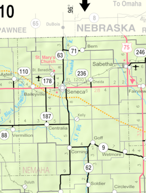
Nemaha County has several cities and smaller communities. Some communities might have parts in a nearby county.
Cities in Nemaha County
Unincorporated Communities
These are smaller communities that are not officially organized as cities. Some are called Census-Designated Places (CDP) by the U.S. Census Bureau.
- Baileyville† (CDP)
- Berwick
- Capioma
- Kelly† (CDP)
- Neuchatel
- St. Benedict† (CDP)
- Woodlawn
Townships in Nemaha County
Nemaha County is divided into twenty smaller areas called townships. These are like smaller local government areas. The cities of Sabetha and Seneca are separate from these township numbers.
See also
 In Spanish: Condado de Nemaha (Kansas) para niños
 | Lonnie Johnson |
 | Granville Woods |
 | Lewis Howard Latimer |
 | James West |


