
National Register of Historic Places listings in Nemaha County, Kansas facts for kids

This article is about special places in Nemaha County, Kansas that are listed on the National Register of Historic Places. This register is like a special list of buildings, sites, and objects across the United States that are important to history. When a place is on this list, it means it's worth protecting and remembering because of its unique story or how it looks.
In Nemaha County, Kansas, there are 11 different places that have made it onto this important list. Each one has a past that helps us understand what life was like long ago.
What is the National Register of Historic Places?
The National Register of Historic Places is the official list of the nation's historic places worth saving. It's part of a program by the United States government to help people appreciate and protect America's historic and archaeological sites. Places on the list can be buildings, structures, objects, sites, or even entire historic districts. They are chosen because they are important in American history, architecture, archaeology, engineering, or culture.
Historic Places in Nemaha County
Nemaha County has several interesting spots on this list. Let's explore a few of them:
Old Bridges and Water Systems
Some of the oldest structures on the list are important for how people traveled or got water in the past.
Clear Creek Camel Truss Bridge
Imagine a bridge that looks like a camel's hump! The Clear Creek Camel Truss Bridge is one such bridge near Baileyville, Kansas. It was added to the list in 2003. This type of bridge design was common a long time ago and shows how engineers built strong crossings over water.
Hand-Dug City Water Well
In Seneca, Kansas, there's a Hand-Dug City Water Well that was added to the list in 2007. This well reminds us how towns used to get their water before modern plumbing. It's a cool example of early community efforts.
Lake Nemaha Dam Guardrail
Also near Seneca, the Lake Nemaha Dam Guardrail became historic in 2008. Even a guardrail can tell a story about how important safety and public works projects were in the past.
Important Buildings and Schools
Many historic places are buildings where people lived, learned, or worked.
Marion Hall
In Baileyville, you can find Marion Hall, which was listed in 2001. This building, located at the junction of Main and 1st Streets, likely played a big role in the town's community life.
Nemaha County Jail and Sheriff's House
The Nemaha County Jail and Sheriff's House in Seneca, listed in 2004, is a fascinating look into the county's law enforcement history. It shows where the sheriff lived and where prisoners were kept.
Old Albany Schoolhouse
North of Sabetha, the Old Albany Schoolhouse was one of the first places in the county to be listed, back in 1972. This old schoolhouse helps us imagine what school was like for kids many years ago.
Prairie Grove School
Another school, the Prairie Grove School, located southeast of Seneca, was added to the list in 2006. These old school buildings are important reminders of how education developed in the area.
St. Mary's Church
Northeast of Baileyville, St. Mary's Church became a historic site in 1980. Churches often serve as important community centers and have beautiful architecture.
Town Centers and Post Offices
Sometimes, entire areas or public buildings are recognized for their historical value.
Seneca Main Street Historic District
The Seneca Main Street Historic District was listed in 2006. This isn't just one building; it's a whole section of Main Street in Seneca! It includes several buildings that together show what a busy town center looked like in the past.
US Post Office-Sabetha
The US Post Office-Sabetha, listed in 1989, is an example of important government buildings. Post offices were, and still are, vital for communication and connecting communities.
US Post Office-Seneca
Similarly, the US Post Office-Seneca was also listed in 1989. These buildings often have unique architectural styles from the time they were built.
Why are these places important?
These historic places help us learn about the past. They show us how people lived, worked, and built things in Nemaha County many years ago. By protecting them, we make sure that future generations can also learn from and enjoy these special parts of history.
Images for kids
-

The Hand-Dug City Water Well in Seneca.
-
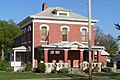
The Nemaha County Jail and Sheriff's House.
-
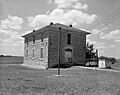
The Old Albany Schoolhouse.
-
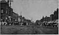
Main Street in Seneca, Kansas, in 1916.
-

The US Post Office in Sabetha.


