
Seneca, Kansas facts for kids
Quick facts for kids
Seneca, Kansas
|
|
|---|---|
|
City and County seat
|
|

Post Office in Seneca (2021)
|
|

Location within Nemaha County and Kansas
|
|

|
|
| Country | United States |
| State | Kansas |
| County | Nemaha |
| Founded | 1857 |
| Incorporated | 1870 |
| Named for | Seneca County, Ohio |
| Area | |
| • Total | 1.67 sq mi (4.32 km2) |
| • Land | 1.67 sq mi (4.32 km2) |
| • Water | 0.00 sq mi (0.00 km2) |
| Elevation | 1,152 ft (351 m) |
| Population
(2020)
|
|
| • Total | 2,139 |
| • Density | 1,281/sq mi (495.1/km2) |
| Time zone | UTC-6 (CST) |
| • Summer (DST) | UTC-5 (CDT) |
| ZIP code |
66538
|
| Area code | 785 |
| FIPS code | 20-63950 |
| GNIS ID | 485651 |
Seneca is a city located in Nemaha County, Kansas, in the United States. It is the main city, also known as the county seat, for Nemaha County. In 2020, about 2,139 people lived there.
Contents
History of Seneca
Seneca was founded in 1857. It got its name from Seneca County, Ohio. The first post office in Seneca opened in November 1858.
The city grew along an important wagon route. This route went from St. Joseph, Missouri all the way to Oregon and California. In 1860, a British explorer named Richard Francis Burton passed through. He described Seneca as "a city consisting of a few shanties," meaning it was quite small back then.
Seneca was also a stop on the famous Pony Express in the early 1860s. The Pony Express was a fast mail service that used riders on horses. The station in Seneca was located at the Smith Hotel, which is now at Fourth and Main Streets. Seneca officially became a city in 1870.
The city even had its own minor league baseball team! The Seneca team played in 1910 as part of the Class D level Eastern Kansas League. They finished in second place that season. Their home games were played at City Park.
Geography of Seneca
Seneca is a city made entirely of land. According to the United States Census Bureau, the city covers about 1.63 square miles (4.22 square kilometers).
People of Seneca
| Historical population | |||
|---|---|---|---|
| Census | Pop. | %± | |
| 1880 | 1,203 | — | |
| 1890 | 2,032 | 68.9% | |
| 1900 | 1,846 | −9.2% | |
| 1910 | 1,806 | −2.2% | |
| 1920 | 1,885 | 4.4% | |
| 1930 | 1,864 | −1.1% | |
| 1940 | 2,015 | 8.1% | |
| 1950 | 1,911 | −5.2% | |
| 1960 | 2,072 | 8.4% | |
| 1970 | 2,182 | 5.3% | |
| 1980 | 2,389 | 9.5% | |
| 1990 | 2,027 | −15.2% | |
| 2000 | 2,122 | 4.7% | |
| 2010 | 1,991 | −6.2% | |
| 2020 | 2,139 | 7.4% | |
| U.S. Decennial Census | |||
The population of Seneca has changed over the years. In 2010, there were 1,991 people living in the city. By 2020, the population had grown to 2,139 people.
Education in Seneca
Students in Seneca are served by the Nemaha Central USD 115 public school district. This district provides education for the community.
Famous People from Seneca
Many notable people have connections to Seneca:
- Roy E. Moore: Known as the father of American gymnastics.
- John Riggins: A Pro Football Hall of Famer who won a Super Bowl with the Washington Redskins. He was named the Most Valuable Player (MVP) of Super Bowl XVII.
- Ira K. Wells: A judge for the United States District Court for the District of Puerto Rico.
- Edward White: A veteran of the Philippine–American War and a recipient of the Medal of Honor, a very high military award.
Images for kids
-
Nemaha County Historical Society (previously a Jail and Sheriff residence) (2015)
-
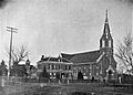
Saints Peter and Paul Catholic Church (1916)

.jpg)
See also
 In Spanish: Seneca (Kansas) para niños
