Seneca County, Ohio facts for kids
Quick facts for kids
Seneca County
|
|||
|---|---|---|---|

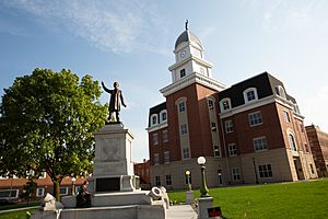
Seneca County Justice Center in Tiffin, Ohio
|
|||
|
|||

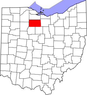
Location within the U.S. state of Ohio
|
|||
 Ohio's location within the U.S. |
|||
| Country | |||
| State | |||
| Founded | April 1, 1824 | ||
| Named for | the Seneca nation | ||
| Seat | Tiffin | ||
| Largest city | Tiffin | ||
| Area | |||
| • Total | 553 sq mi (1,430 km2) | ||
| • Land | 551 sq mi (1,430 km2) | ||
| • Water | 1.8 sq mi (5 km2) 0.3% | ||
| Population
(2020)
|
|||
| • Total | 55,069 |
||
| • Density | 100/sq mi (40/km2) | ||
| Time zone | UTC−5 (Eastern) | ||
| • Summer (DST) | UTC−4 (EDT) | ||
| Congressional district | 5th | ||
Seneca County is a county located in the northwestern part of Ohio, a state in the United States. In 2020, about 55,069 people lived here. The main town, or county seat, is Tiffin.
The county was officially started in 1824. It is named after the Seneca nation, a group of Native Americans who were part of the Iroquois Confederacy. They used to live in areas that are now New York, Pennsylvania, and Ohio. Seneca County is part of a larger area that includes Tiffin and Findlay, Ohio.
Contents
History of Seneca County
This area was home to many different indigenous peoples for a very long time. Later, during the time of early European settlement, French, British, and American fur traders came here. They traded with the Native American groups living in the region.
Early Settlers and Growth
Not many European Americans lived in Seneca County until the 1830s. But then, many settlers from New York and New England started moving in. This happened partly because the Erie Canal was finished in New York. The canal made it easier to travel and connect markets from the Great Lakes to New York City.
By 1860, the number of people in Seneca County had grown a lot. The land was mostly used for agriculture, like farming. The population grew slowly after that.
Recent Population Changes
Over time, the county's population saw periods of growth, especially around the end of the 1800s and after World War II. In 1980, the population reached its highest point with 61,901 people. Since then, the number of people living in Seneca County has slowly gone down. This is mainly because more people move out of the county than move in each year.
Geography and Landscape
Seneca County covers about 553 square miles. Most of this area, about 551 square miles, is land. Only a small part, about 1.8 square miles, is water.
Land Use and Terrain
A large part of the county, almost 80%, is agricultural land used for farming. About 10% of the county is covered by forests. The rest of the land is developed for towns and roads, or used for pastureland where animals graze.
The land in Seneca County is mostly flat. It gently slopes from about 290 meters (950 feet) above sea level in the southeast to about 210 meters (690 feet) in the northwest. Most of the county is between 230 and 260 meters (750-850 feet) above sea level.
Almost all of the county's water flows into the Sandusky River. This river flows through the county from south to north, slightly west of the middle. The city of Tiffin is built on both sides of the Sandusky River. The river eventually flows north into Lake Erie. There are some steeper areas along the river where its smaller streams have carved out ravines.
Climate and Weather
Seneca County has a continental climate. This means it has warm summers and cold winters. The Great Lakes nearby help to make the temperatures a little milder. However, after most of the forests were cut down for farming, the local weather patterns changed.
Winters can be very cold, with lots of snow. This is often due to "lake-effect snow" which happens when cold air moves over warmer lake waters. Summers are often hot and very humid. The flat land means there are no mountains to block the cold winter winds coming from Canada. This can lead to very cold "wind chill" temperatures.
Neighboring Counties
Seneca County shares its borders with several other counties:
- Sandusky County (north)
- Huron County (east)
- Crawford County (southeast)
- Wyandot County (southwest)
- Hancock County (west)
- Wood County (northwest)
Population Information
| Historical population | |||
|---|---|---|---|
| Census | Pop. | %± | |
| 1830 | 5,159 | — | |
| 1840 | 18,128 | 251.4% | |
| 1850 | 27,104 | 49.5% | |
| 1860 | 30,868 | 13.9% | |
| 1870 | 30,827 | −0.1% | |
| 1880 | 36,947 | 19.9% | |
| 1890 | 40,869 | 10.6% | |
| 1900 | 41,163 | 0.7% | |
| 1910 | 42,421 | 3.1% | |
| 1920 | 43,176 | 1.8% | |
| 1930 | 47,941 | 11.0% | |
| 1940 | 48,499 | 1.2% | |
| 1950 | 52,978 | 9.2% | |
| 1960 | 59,326 | 12.0% | |
| 1970 | 60,696 | 2.3% | |
| 1980 | 61,901 | 2.0% | |
| 1990 | 59,733 | −3.5% | |
| 2000 | 58,683 | −1.8% | |
| 2010 | 56,745 | −3.3% | |
| 2020 | 55,069 | −3.0% | |
| U.S. Decennial Census 1790-1960 1900-1990 1990-2000 2020 |
|||
People in Seneca County
In 2010, there were 56,745 people living in Seneca County. Most people (93.7%) were white. About 2.3% were Black or African American, and 0.6% were Asian. People of Hispanic or Latino origin made up 4.4% of the population.
Many people in the county have German (47.6%), Irish (10.4%), American (8.9%), or English (8.2%) backgrounds.
The average age of people in Seneca County in 2010 was 38.8 years old. About 31.4% of households had children under 18 living with them.
Transportation Routes
Main Highways
Other Important Roads
Airports in the County
- Bandit Field Airdrome
- Fostoria Metropolitan Airport
- Seneca County Airport
- Weiker Airport
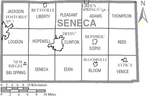
Communities in Seneca County
Cities You Can Visit
- Bellevue (partly in Seneca County)
- Fostoria (partly in Seneca County)
- Tiffin (the county seat, or main town)
Villages in the County
- Attica
- Bettsville
- Bloomville
- Green Springs (partly in Seneca County)
- New Riegel
- Republic
Townships (Smaller Local Areas)
- Adams
- Big Spring
- Bloom
- Clinton
- Eden
- Hopewell
- Jackson
- Liberty
- Loudon
- Pleasant
- Reed
- Scipio
- Seneca
- Thompson
- Venice
Census-Designated Places (Smaller Communities)
Unincorporated Communities (Even Smaller Areas)
Fun Places to Visit
- Seneca Caverns are underground caves you can explore!
Natural History and Wildlife
Long ago, before many people settled here, most of Seneca County was covered in woodlands. There were also large swampy areas, like part of the Great Black Swamp in the northwest. Native Americans and early settlers mostly used the area for hunting animals with valuable fur. There wasn't much farming until the early 1800s.
Changes to the Environment
Starting in the early to mid-1800s, many trees in the county were cut down. This big change led to a huge shift in the local wildlife. Animals that live in grasslands and farmlands started to replace the animals that lived in the forests.
Birds that migrate, like waterbirds, used to be common here. They would stop in the swamps on their way south. Now, they are rare and only gather in the few remaining large water areas. The passenger pigeon, a bird that is now extinct, used to have places to rest and nest in the county when it was still wooded. But by the 1860s, cutting down the forests drove these birds away. This was a sign of their eventual extinction due to massive hunting and loss of their forest homes.
Birds of Seneca County
Several types of waterbirds that used to be seen often during migration are now rarely spotted. These include the common loon, American wigeon, redhead, canvasback, and several types of mergansers.
Land birds were not as badly affected. However, some, like the ruffed grouse, wild turkey, golden eagle, and marsh wren, had mostly or completely disappeared by 1900. We don't know how many of the many New World warbler species, which now only pass through, used to breed in Seneca County.
The Eskimo curlew, which might be extinct today, used to pass through Ohio until about 1900. It's not clear how often it was seen in Seneca County after the forests were cleared. The extinct Carolina parakeet might have also visited Seneca County before 1862.
An interesting fact is that the only time a long-billed murrelet (a type of seabird from the North Pacific) was seen in Ohio was in Seneca County. One was spotted and photographed in November 1996. The rare Kirtland's warbler is now increasing in numbers and might sometimes be seen as far north as Seneca County.
Some birds that were brought to the area by people are now common. The house sparrow has been common since the late 1800s. The ring-necked pheasant, another bird brought from Europe, has lived and bred here since at least 1901, but it has never become super common.
Images for kids
-
Seneca County Justice Center in Tiffin, Ohio
See also
 In Spanish: Condado de Seneca (Ohio) para niños
 | Sharif Bey |
 | Hale Woodruff |
 | Richmond Barthé |
 | Purvis Young |


