Wyandot County, Ohio facts for kids
Quick facts for kids
Wyandot County
|
|||
|---|---|---|---|

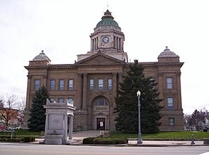
Wyandot County Courthouse in Upper Sandusky
|
|||
|
|||

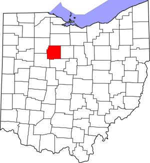
Location within the U.S. state of Ohio
|
|||
 Ohio's location within the U.S. |
|||
| Country | |||
| State | |||
| Founded | February 3, 1845 | ||
| Named for | the Wyandot people | ||
| Seat | Upper Sandusky | ||
| Largest city | Upper Sandusky | ||
| Area | |||
| • Total | 408 sq mi (1,060 km2) | ||
| • Land | 407 sq mi (1,050 km2) | ||
| • Water | 0.7 sq mi (2 km2) 0.2%% | ||
| Population
(2020)
|
|||
| • Total | 21,900 |
||
| • Density | 54/sq mi (21/km2) | ||
| Time zone | UTC−5 (Eastern) | ||
| • Summer (DST) | UTC−4 (EDT) | ||
| Congressional districts | 4th, 5th | ||
Wyandot County is a cool place in the northwestern part of Ohio, a state in the United States. It's a type of area called a county. In 2020, about 21,900 people lived here.
The main town, or county seat, is Upper Sandusky. The county got its name from the Wyandot people, also known as the Wyandot Indians. They lived in this area for a long time. Their name means things like "around the plains" or "dwellers on the peninsula." Wyandot County officially started on February 3, 1845. It was created from parts of other nearby counties.
Contents
Exploring Wyandot County's Location
Wyandot County is located in the northwest part of Ohio. It covers a total area of about 408 square miles. Most of this area, about 407 square miles, is land. Only a tiny bit, 0.7 square miles, is water.
Counties Nearby
Wyandot County shares its borders with several other counties:
- Seneca County (to the north)
- Crawford County (to the east)
- Marion County (to the south)
- Hardin County (to the southwest)
- Hancock County (to the northwest)
Who Lives in Wyandot County?
| Historical population | |||
|---|---|---|---|
| Census | Pop. | %± | |
| 1850 | 11,194 | — | |
| 1860 | 15,596 | 39.3% | |
| 1870 | 18,553 | 19.0% | |
| 1880 | 22,395 | 20.7% | |
| 1890 | 21,722 | −3.0% | |
| 1900 | 21,125 | −2.7% | |
| 1910 | 20,760 | −1.7% | |
| 1920 | 19,481 | −6.2% | |
| 1930 | 19,036 | −2.3% | |
| 1940 | 19,218 | 1.0% | |
| 1950 | 19,785 | 3.0% | |
| 1960 | 21,648 | 9.4% | |
| 1970 | 21,826 | 0.8% | |
| 1980 | 22,651 | 3.8% | |
| 1990 | 22,254 | −1.8% | |
| 2000 | 22,908 | 2.9% | |
| 2010 | 22,615 | −1.3% | |
| 2020 | 21,900 | −3.2% | |
| U.S. Decennial Census 1790-1960 1900-1990 1990-2000 2020 |
|||
Looking at the 2010 Census
In 2010, there were 22,615 people living in Wyandot County. Most people, about 96.9%, were white. Other groups included Asian, American Indian, and Black or African American people. About 2.2% of the population was of Hispanic or Latino background.
Many people in the county have German roots (43.3%). Other common backgrounds include American, Irish, and English.
About one-third of the homes had children under 18 living there. The average age of people in the county was about 40.5 years old.
Towns and Villages in Wyandot County
Wyandot County has one main city and several smaller towns and villages.
City
- Upper Sandusky (This is the county seat, where the main government offices are.)
Towns and Villages
Townships
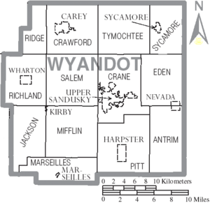
Townships are smaller local government areas within the county.
- Antrim
- Crane
- Crawford
- Eden
- Jackson
- Marseilles
- Mifflin
- Pitt
- Richland
- Ridge
- Salem
- Sycamore
- Tymochtee
Other Communities
- McCutchenville (This is a "census-designated place," meaning it's a community that the census bureau tracks.)
There are also several smaller, unincorporated communities:
Famous People from Wyandot County
- Darius D. Hare: He was born near Adrian and later became a United States Congressman for Ohio.
- John Stewart: He was a Methodist missionary.
Cool Places and Activities
Wyandot County is home to Ohio's largest solar energy farm! It covers 80 acres of land next to the Wyandot County Airport. This farm has 159,000 solar panels that collect energy from the sun. It can produce 12 megawatts of power, which is a lot of electricity! The farm officially opened on August 19, 2010.
See also
 In Spanish: Condado de Wyandot para niños
 | Janet Taylor Pickett |
 | Synthia Saint James |
 | Howardena Pindell |
 | Faith Ringgold |


