Mexico, Ohio facts for kids
Quick facts for kids
Mexico, Ohio
|
|
|---|---|

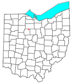
Location of Mexico, Ohio
|
|
| Country | United States |
| State | Ohio |
| County | Wyandot |
| Township | Tymochtee |
| Elevation | 807 ft (246 m) |
| Time zone | UTC-5 (Eastern (EST)) |
| • Summer (DST) | UTC-4 (EDT) |
| GNIS feature ID | 1048970 |
Mexico is a small community in Ohio, United States. It is an "unincorporated community". This means it's a place where people live, but it doesn't have its own local government like a city or town does. Mexico is located in northeastern Tymochtee Township, which is part of Wyandot County.
The History of Mexico, Ohio
Mexico, Ohio, was first planned and settled in the year 1832. The community was given its name to honor the Mexican War of Independence. This was a big event where Mexico fought for its freedom.
When Mexico was first created, it was part of Crawford County, Ohio. However, in 1845, the land where Mexico is located became part of the new Wyandot County, Ohio. A post office was opened in Mexico in 1837. This office helped people send and receive mail for many years. It stayed open until 1902.
 | George Robert Carruthers |
 | Patricia Bath |
 | Jan Ernst Matzeliger |
 | Alexander Miles |

