Wyandotte County, Kansas facts for kids
Quick facts for kids
Wyandotte County
|
|||
|---|---|---|---|
|
Consolidated city-county
|
|||
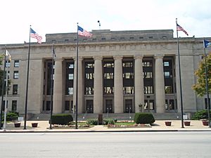
Wyandotte County Courthouse in Kansas City (2009)
|
|||
|
|||
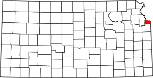
Location within the U.S. state of Kansas
|
|||
 Kansas's location within the U.S. |
|||
| Country | |||
| State | |||
| Founded | January 29, 1859 | ||
| Named for | Wyandot people | ||
| Seat | Kansas City | ||
| Largest city | Kansas City | ||
| Area | |||
| • Total | 156 sq mi (400 km2) | ||
| • Land | 152 sq mi (390 km2) | ||
| • Water | 4.6 sq mi (12 km2) 2.9% | ||
| Population
(2020)
|
|||
| • Total | 169,245 | ||
| • Estimate
(2021)
|
167,046 |
||
| • Density | 1,039.0/sq mi (401.2/km2) | ||
| Time zone | UTC−6 (Central) | ||
| • Summer (DST) | UTC−5 (CDT) | ||
| Congressional districts | 2nd, 3rd | ||
Wyandotte County is a county in the state of Kansas. Its main city is Kansas City. These two places share a special "unified government." In 2020, about 169,245 people lived here. This makes it the fourth-biggest county in Kansas by population. The county got its name from the Wyandot tribe.
Contents
History of Wyandotte County
The Wyandot Tribe
The county is named after the Wyandot people, also known as Wyandott or Wyandotte Indians. The French in Canada called them Huron. But they called themselves Wendat. They were related to the Iroquois tribe. Sometimes, they even fought with them. The Wyandot hoped to keep white Americans out of their land. They wanted the Ohio River to be the border between the United States and Canada.
One group of the Wyandot moved to what is now Ohio. They often chose to live like the Anglo-Americans. Many became Christians because of missionaries. In 1843, they moved to the area that is now Wyandotte County. There, they built a community. They worked together with the Anglo settlers. The Christian Munsee also helped settle this area early on.
The Wyandot in Kansas created their own government. It was based on a constitution they made in Ohio. They helped set up the government for Kansas and Nebraska territories. They even elected one of their own as a territorial governor.
Other Historical Facts
Wyandotte County officially started in 1859. Tenskwatawa, who was Tecumseh's brother, was known as "the Prophet." He fought in the Battle of Tippecanoe in 1811. He was buried at Whitefeather Spring. This is a Native American historical site in Kansas City. It was added to the National Register of Historic Places in 1975.
In the 1880s, the Kansas City Smelting and Refining Company was a big employer. Over 250 men worked there. They processed metals from mining areas.
Delaware Crossing and Grinter Ferry
The Delaware Crossing was an old Indian trail. It met the Kaw River there. Around 1831, Moses Grinter was one of the first white settlers. He started the Grinter Ferry on the Kansas River. His home was called the Grinter Place. Traders, freighters, and soldiers used the ferry. They traveled between Fort Leavenworth and Fort Scott. Others crossed this area on their way to Santa Fe.
Geography of Wyandotte County
Wyandotte County covers about 156 square miles. About 152 square miles are land. The rest, about 4.6 square miles, is water. It is the smallest county in Kansas by land area.
Land Features
The county has gently rolling hills. The Kansas River forms part of its southern border. The land generally gets higher as you go north. This is because it moves away from the Kansas River and Missouri River.
Rivers and Streams
The county gets its water from natural creeks and streams. These flow into the Kaw River. The Kaw River is part of the Missouri River basin. The area gets plenty of rain.
Neighboring Counties
Wyandotte County shares borders with these other counties:
- Platte County, Missouri (to the north)
- Clay County, Missouri (to the northeast)
- Jackson County, Missouri (to the east)
- Johnson County (to the south)
- Leavenworth County (to the west)
People and Population
| Historical population | |||
|---|---|---|---|
| Census | Pop. | %± | |
| 1860 | 2,609 | — | |
| 1870 | 10,015 | 283.9% | |
| 1880 | 19,143 | 91.1% | |
| 1890 | 54,407 | 184.2% | |
| 1900 | 73,227 | 34.6% | |
| 1910 | 100,068 | 36.7% | |
| 1920 | 122,218 | 22.1% | |
| 1930 | 141,211 | 15.5% | |
| 1940 | 145,071 | 2.7% | |
| 1950 | 165,318 | 14.0% | |
| 1960 | 185,495 | 12.2% | |
| 1970 | 186,845 | 0.7% | |
| 1980 | 172,335 | −7.8% | |
| 1990 | 161,993 | −6.0% | |
| 2000 | 157,882 | −2.5% | |
| 2010 | 157,505 | −0.2% | |
| 2020 | 169,245 | 7.5% | |
| 2023 (est.) | 165,281 | 4.9% | |
| U.S. Decennial Census 1790–1960 1900–1990 1990–2000 2010–2020 |
|||
Wyandotte County is part of the larger Kansas City, MO-KS Metropolitan Statistical Area. This means it's part of a big group of cities and towns.
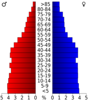
In 2000, there were about 157,882 people living in the county. There were almost 60,000 households. A household is a group of people living in one home. The population density was about 1,043 people per square mile.
The people living in the county came from many different backgrounds. About 58% were White, and 28% were Black or African American. About 16% of the people were Hispanic or Latino.
Many households had children under 18 living with them. About 42% were married couples. The average household had 2.62 people.
The median age in the county was 32 years old. This means half the people were younger than 32, and half were older. About 28.5% of the population was under 18 years old.
The median income for a household was about $33,784. This is the middle income for all households. About 16.5% of the population lived below the poverty line. This included 23% of those under age 18.
Wyandotte County has the highest percentage of people in Kansas who use public transportation for work. About 1.4% of residents do.
Government and Law
Law Enforcement
The Wyandotte County Sheriff's Department is in charge of the county jail. Other police departments serve specific cities. These include the Bonner Springs Police Department, Edwardsville Police Department, and the Kansas City Kansas Police Department.
Local Rules
For a long time, Wyandotte County was a "dry" county. This meant it had strict rules about selling alcohol. In 1986, the state's rules changed. Voters in Wyandotte County then allowed the sale of alcohol in restaurants. In 1988, they removed the rule about how much food had to be sold with it.
Presidential Elections
| Year | Republican | Democratic | Third party | |||
|---|---|---|---|---|---|---|
| No. | % | No. | % | No. | % | |
| 2020 | 18,934 | 33.18% | 36,788 | 64.46% | 1,349 | 2.36% |
| 2016 | 15,806 | 32.10% | 30,146 | 61.22% | 3,291 | 6.68% |
| 2012 | 15,496 | 30.45% | 34,302 | 67.40% | 1,095 | 2.15% |
| 2008 | 16,506 | 28.75% | 39,865 | 69.44% | 1,038 | 1.81% |
| 2004 | 17,919 | 33.56% | 34,923 | 65.40% | 559 | 1.05% |
| 2000 | 14,024 | 29.05% | 32,411 | 67.14% | 1,837 | 3.81% |
| 1996 | 14,011 | 28.22% | 31,252 | 62.94% | 4,391 | 8.84% |
| 1992 | 12,872 | 21.06% | 34,397 | 56.27% | 13,855 | 22.67% |
| 1988 | 19,097 | 32.70% | 38,678 | 66.23% | 624 | 1.07% |
| 1984 | 27,459 | 42.81% | 36,042 | 56.20% | 635 | 0.99% |
| 1980 | 23,012 | 38.21% | 32,763 | 54.40% | 4,448 | 7.39% |
| 1976 | 23,141 | 36.99% | 37,478 | 59.91% | 1,936 | 3.09% |
| 1972 | 34,157 | 52.70% | 28,206 | 43.52% | 2,453 | 3.78% |
| 1968 | 23,091 | 33.38% | 34,189 | 49.43% | 11,891 | 17.19% |
| 1964 | 20,553 | 31.45% | 43,442 | 66.47% | 1,356 | 2.07% |
| 1960 | 34,764 | 45.27% | 41,433 | 53.95% | 604 | 0.79% |
| 1956 | 34,604 | 47.64% | 37,842 | 52.10% | 186 | 0.26% |
| 1952 | 34,648 | 47.04% | 38,751 | 52.61% | 258 | 0.35% |
| 1948 | 24,398 | 36.53% | 41,366 | 61.94% | 1,024 | 1.53% |
| 1944 | 26,817 | 44.74% | 32,914 | 54.91% | 214 | 0.36% |
| 1940 | 28,152 | 42.24% | 38,239 | 57.38% | 252 | 0.38% |
| 1936 | 26,239 | 40.62% | 38,101 | 58.98% | 256 | 0.40% |
| 1932 | 25,471 | 43.30% | 32,629 | 55.47% | 721 | 1.23% |
| 1928 | 32,829 | 65.69% | 16,884 | 33.78% | 265 | 0.53% |
| 1924 | 23,881 | 59.48% | 8,913 | 22.20% | 7,354 | 18.32% |
| 1920 | 19,294 | 57.25% | 13,737 | 40.76% | 671 | 1.99% |
| 1916 | 13,863 | 41.86% | 17,850 | 53.89% | 1,408 | 4.25% |
| 1912 | 2,107 | 11.18% | 7,370 | 39.10% | 9,371 | 49.72% |
| 1908 | 8,684 | 47.56% | 8,923 | 48.87% | 652 | 3.57% |
| 1904 | 9,147 | 64.18% | 3,815 | 26.77% | 1,290 | 9.05% |
| 1900 | 8,133 | 51.75% | 7,304 | 46.47% | 280 | 1.78% |
| 1896 | 6,852 | 49.44% | 6,882 | 49.65% | 126 | 0.91% |
| 1892 | 5,889 | 51.10% | 0 | 0.00% | 5,635 | 48.90% |
| 1888 | 5,431 | 55.41% | 4,155 | 42.39% | 215 | 2.19% |
| 1884 | 3,232 | 56.33% | 2,301 | 40.10% | 205 | 3.57% |
| 1880 | 2,410 | 55.09% | 1,729 | 39.52% | 236 | 5.39% |
Wyandotte County has mostly voted for Democratic presidents since the 1930s. This is different from most other counties in Kansas. It's because the county is very urban and has many different groups of people. The only time a Democrat lost in Wyandotte County since 1932 was in 1972. That year, Richard Nixon won almost every county in the country.
Economy and Attractions
Village West is a major area for growth in Kansas City and Wyandotte County. It's located where two big highways, I-70 and I-435, meet.
Fun Places to Visit
Village West has many attractions. These include:
- The Kansas Speedway, where car races happen.
- Hollywood Casino, a place for games and entertainment.
- Legends Outlets Kansas City, a large shopping center.
- Stores like Cabela's and Nebraska Furniture Mart.
- Great Wolf Lodge, a popular indoor water park.
- Legends Field, home to the Kansas City Monarchs baseball team.
- Children's Mercy Park, where Sporting Kansas City soccer team plays.
Other fun spots in the county are:
- Azura Amphitheater, an outdoor concert venue.
- The National Agricultural Center and Hall of Fame, which teaches about farming.
- Wyandotte County Park, a nice place to relax outdoors.
- Sunflower Hills Golf Course, for those who like to golf.
Colleges and Universities
Wyandotte County has several colleges:
- Public Colleges:
* Kansas City Kansas Community College * University of Kansas Medical Center
- Private Colleges:
* Donnelly College
Schools in the County
Wyandotte County has different school districts and private schools.
- School Districts:
* Turner USD 202 * Piper USD 203 * Bonner Springs–Edwardsville USD 204 * Kansas City USD 500
- Private Schools:
* Primary Schools: * Resurrection Grade School * St. Patrick's Grade School * Christ the King Grade School * Secondary Schools: * Bishop Ward High School
- Other Schools:
* Kansas State School for the Blind (KSSB)
Communities in Wyandotte County
Cities
- Bonner Springs (also partly in Leavenworth and Johnson counties)
- Edwardsville
- Kansas City (this is the main city and county seat)
- Lake Quivira (also partly in Johnson County)
Neighborhoods
Townships
Wyandotte County has only one township called Delaware. The cities of Bonner Springs, Kansas City, and Lake Quivira are separate from the township.
| Township | FIPS | Population center |
Population | Population density /km2 (/sq mi) |
Land area km2 (sq mi) |
Water area km2 (sq mi) |
Water % | Geographic coordinates |
|---|---|---|---|---|---|---|---|---|
| Delaware | 17475 | Edwardsville | 4,200 | 141 (364) | 30 (12) | 1 (0) | 3.97% | 39°3′50″N 94°49′8″W / 39.06389°N 94.81889°W |
| Sources: | ||||||||
In 2010, the city of Edwardsville also became separate. The rest of the Delaware township then had only 31 people living on a small piece of land.
See also
 In Spanish: Condado de Wyandotte para niños
|
|
 | Percy Lavon Julian |
 | Katherine Johnson |
 | George Washington Carver |
 | Annie Easley |


