
Clay County, Missouri facts for kids
Quick facts for kids
Clay County
|
||
|---|---|---|

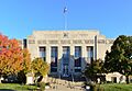
South side of the Clay County Courthouse (designed by Wight and Wight) in Liberty
|
||
|
||

Location within the U.S. state of Missouri
|
||
 Missouri's location within the U.S. |
||
| Country | ||
| State | ||
| Founded | January 2, 1822 | |
| Named for | Henry Clay | |
| Seat | Liberty | |
| Largest city | Kansas City | |
| Area | ||
| • Total | 409 sq mi (1,060 km2) | |
| • Land | 397 sq mi (1,030 km2) | |
| • Water | 11 sq mi (30 km2) 2.8% | |
| Population
(2020)
|
||
| • Total | 253,335 |
|
| • Density | 620/sq mi (240/km2) | |
| Time zone | UTC−6 (Central) | |
| • Summer (DST) | UTC−5 (CDT) | |
| Congressional districts | 5th, 6th | |

Clay County is a county in the state of Missouri, USA. It is part of the larger Kansas City metropolitan area. In 2020, about 253,335 people lived here. This makes it the fifth-most populated county in Missouri.
The main city and government center of Clay County is Liberty. The county was started on January 2, 1822. It was named after Henry Clay, a famous American politician from Kentucky. Clay County includes many northern towns that are part of the Kansas City area. It also has a big part of Kansas City, Missouri itself. The county also runs the Midwest National Air Center near Excelsior Springs.
Contents
History of Clay County
Clay County was first settled by people who moved from states like Kentucky, Tennessee, and Virginia. These settlers brought with them people they had enslaved. They started growing crops like hemp and tobacco, similar to what was grown in their home states.
Because many settlers came from the Southern states, this area, including Clay County, became known as Little Dixie. In 1860, about one-fourth of the people living in Clay County were enslaved.
In November 1833, many members of the Church of Jesus Christ of Latter Day Saints came to Clay County. They were looking for safety after being forced out of Jackson County, Missouri. However, by 1836, they were also driven from Clay County. Important leaders of this church, like Joseph Smith, were held in the jail in Liberty for several months. In 2012, the LDS Church built the Kansas City Missouri Temple not far from the old Liberty Jail site.
Geography of Clay County
Clay County covers about 409 square miles. Most of this area, 397 square miles, is land. About 11 square miles, or 2.8%, is covered by water. It is the fourth-smallest county in Missouri by land area.
Neighboring Counties
- Clinton County (north)
- Ray County (east)
- Jackson County (south)
- Wyandotte County, Kansas (southwest)
- Platte County (west)
Main Roads
 Interstate 29
 Interstate 35
 Interstate 435
 U.S. Route 69
 U.S. Route 71
 U.S. Route 169
 Route 1
 Route 9
 Route 10
 Route 33
 Route 92
 Route 152
 Route 210
 Route 291
People of Clay County
| Historical population | |||
|---|---|---|---|
| Census | Pop. | %± | |
| 1830 | 5,338 | — | |
| 1840 | 8,283 | 55.2% | |
| 1850 | 10,382 | 25.3% | |
| 1860 | 13,023 | 25.4% | |
| 1870 | 15,564 | 19.5% | |
| 1880 | 15,571 | 0.0% | |
| 1890 | 19,856 | 27.5% | |
| 1900 | 18,903 | −4.8% | |
| 1910 | 20,302 | 7.4% | |
| 1920 | 20,455 | 0.8% | |
| 1930 | 26,811 | 31.1% | |
| 1940 | 30,417 | 13.4% | |
| 1950 | 45,221 | 48.7% | |
| 1960 | 87,474 | 93.4% | |
| 1970 | 123,322 | 41.0% | |
| 1980 | 136,488 | 10.7% | |
| 1990 | 153,411 | 12.4% | |
| 2000 | 184,006 | 19.9% | |
| 2010 | 221,939 | 20.6% | |
| 2020 | 253,335 | 14.1% | |
| U.S. Decennial Census 1790-1960 1900-1990 1990-2000 2010-2019 |
|||
In 2010, about 221,939 people lived in Clay County. There were 72,558 households. The population density was about 558 people per square mile.
Most people in the county were White (87.46%). Other groups included Black or African American (5.18%), Asian (2.05%), and Native American (0.53%). About 5.90% of the population was Hispanic or Latino. Many people had German, American, English, or Irish backgrounds.
In 2015, the average household income in Clay County was about $62,099. The income per person was around $29,793. About 5.50% of the population lived below the poverty line. There are 151,042 registered voters in the county.
2020 Census Data
| Race | Number | Percent |
|---|---|---|
| White (Non-Hispanic) | 193,282 | 76.3% |
| Black or African American (Non-Hispanic) | 17,853 | 7.04% |
| Native American (Non-Hispanic) | 1,009 | 0.4% |
| Asian (Non-Hispanic) | 6,059 | 2.4% |
| Pacific Islander (Non-Hispanic) | 1,004 | 0.4% |
| Other/Mixed (Non-Hispanic) | 15,278 | 6.03% |
| Hispanic or Latino | 18,850 | 7.44% |
Education in Clay County
Clay County has several school districts that serve its students.
School Districts
- Excelsior Springs 40 School District
- Kearney R-I School District
- Lawson R-XIV School District
- Liberty 53 School District
- North Kansas City 74 School District
- Platte County R-III School District
- Clinton County R-III School District
- Smithville R-II School District
- Missouri City 56 School District (Elementary only)
Colleges and Universities
- Maple Woods :: Metropolitan Community College—Kansas City—This is a two-year public college.
- William Jewell College – Liberty – This is a private, four-year college.
Libraries, Archives, and Museums
Libraries
- Mid-Continent Public Library
- North Kansas City Public Library
Archives
- Clay County Archives
Museums
- Clay County Museum
- Jesse James Bank Museum
Communities in Clay County
Cities and Towns
Unincorporated Communities
- Arley
- Chandler
- Claysville
- Clevenger
- Ectonville
- Miltondale
- Roosterville
- Stockdale
- Winner
Notable People from Clay County
- Noah Beery (1882–1946), actor
- Wallace Beery (1885–1949), actor
- Obediah Summers (1844–1896), a formerly enslaved person who became a minister and Civil War veteran.
- Frank James (1843–1915), a famous outlaw.
- Jesse James (1847–1882), a famous outlaw.
- John Ellis Martineau (1873–1937), who became the Governor of Arkansas.
- Jesse Sexton (1885–1948), a state senator.
Images for kids
-
South side of the Clay County Courthouse (designed by Wight and Wight) in Liberty
See also
 In Spanish: Condado de Clay (Misuri) para niños
