Ray County, Missouri facts for kids
Quick facts for kids
Ray County
|
|
|---|---|

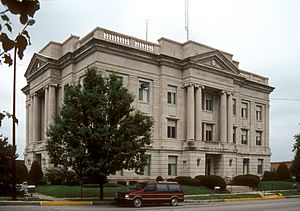
Ray County Courthouse
|
|

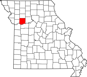
Location within the U.S. state of Missouri
|
|
 Missouri's location within the U.S. |
|
| Country | |
| State | |
| Founded | November 16, 1820 |
| Named for | John Ray, Missouri state legislator |
| Seat | Richmond |
| Largest city | Richmond |
| Area | |
| • Total | 574 sq mi (1,490 km2) |
| • Land | 569 sq mi (1,470 km2) |
| • Water | 5.1 sq mi (13 km2) 0.9% |
| Population
(2020)
|
|
| • Total | 23,158 |
| • Density | 40.34/sq mi (15.577/km2) |
| Time zone | UTC−6 (Central) |
| • Summer (DST) | UTC−5 (CDT) |
| Congressional district | 5th |
Ray County is a county in the northwestern part of Missouri. It's close to the Kansas City metropolitan area. In 2020, about 23,158 people lived here. The main town and county seat is Richmond. Ray County was started on November 16, 1820. It was named after John Ray, who helped create Missouri's first state laws.
Contents
Where is Ray County Located?
Ray County covers about 574 square miles. Most of this area is land, with a small part being water.
Neighboring Counties
Ray County shares borders with several other counties:
- Caldwell County (north)
- Carroll County (east)
- Lafayette County (south)
- Jackson County (southwest)
- Clay County (west)
- Clinton County (northwest)
Main Roads in Ray County
These are the important roads that go through Ray County:
Protected Natural Areas
Part of the Big Muddy National Fish and Wildlife Refuge is located in Ray County. This is a special area that protects nature and wildlife.
Who Lives in Ray County?
| Historical population | |||
|---|---|---|---|
| Census | Pop. | %± | |
| 1830 | 2,657 | — | |
| 1840 | 6,553 | 146.6% | |
| 1850 | 10,373 | 58.3% | |
| 1860 | 14,092 | 35.9% | |
| 1870 | 18,700 | 32.7% | |
| 1880 | 20,190 | 8.0% | |
| 1890 | 24,215 | 19.9% | |
| 1900 | 24,805 | 2.4% | |
| 1910 | 21,451 | −13.5% | |
| 1920 | 20,508 | −4.4% | |
| 1930 | 19,846 | −3.2% | |
| 1940 | 18,584 | −6.4% | |
| 1950 | 15,932 | −14.3% | |
| 1960 | 16,075 | 0.9% | |
| 1970 | 17,599 | 9.5% | |
| 1980 | 21,378 | 21.5% | |
| 1990 | 21,971 | 2.8% | |
| 2000 | 23,354 | 6.3% | |
| 2010 | 23,494 | 0.6% | |
| 2020 | 23,158 | −1.4% | |
| U.S. Decennial Census 1790-1960 1900-1990 1990-2000 2010-2015 |
|||
In 2000, there were 23,354 people living in Ray County. Most people were White (96.50%). About 1.46% were Black or African American. Other groups included Native American, Asian, and people of two or more races. About 1.08% of the population was Hispanic or Latino.
Many families live in Ray County. In 2000, over 35% of households had children under 18. The average age of people in the county was 37 years old.
Ray County's Population in 2020
The 2020 census showed the following breakdown of people in Ray County:
| Race | Number | Percentage |
|---|---|---|
| White (not Hispanic) | 20,893 | 90.22% |
| Black or African American (not Hispanic) | 227 | 1% |
| Native American (not Hispanic) | 133 | 0.57% |
| Asian (not Hispanic) | 76 | 0.33% |
| Pacific Islander (not Hispanic) | 8 | 0.04% |
| Other/Mixed (not Hispanic) | 1,241 | 5.4% |
| Hispanic or Latino | 580 | 2.5% |
Schools and Libraries
Public Schools
Ray County has several public school districts:
- Hardin-Central C-2 School District in Hardin
- Hardin-Central Elementary School (Grades PK-6)
- Hardin-Central High School (Grades 7-12)
- Lawson R-XIV School District in Lawson
- Southwest Elementary School (Grades PK-4)
- Lawson Middle School (Grades 5-8)
- Lawson High School (Grades 9-12)
- Orrick R-XI School District in Orrick
- Orrick Elementary School (Grades PK-6)
- Orrick High School (Grades 7-12)
- Richmond R-XVI School District in Richmond
- Dear Elementary School (Grades PK-1)
- Sunrise Elementary School (Grades 2-5)
- Richmond Middle School (Grades 6-8)
- Richmond High School (Grades 9-12)
Public Libraries
The Ray County Library serves the community.
Towns and Communities
Ray County has several cities, villages, and other communities.
Cities
- Camden
- Crystal Lakes
- Excelsior Springs (mostly in Clay County)
- Fleming
- Hardin
- Henrietta
- Lawson (partly in Clay County)
- Orrick
- Richmond
- Wood Heights
Villages
- Elmira
- Excelsior Estates (small part in Clay County)
- Homestead
Census-Designated Place
Other Small Communities
Townships
- Camden
- Crooked River
- Fishing River
- Grape Grove
- Knoxville
- Orrick
- Polk
- Richmond
Famous People from Ray County
Some well-known people have connections to Ray County:
- Robert Ford, known for being the outlaw who killed Jesse James.
- Chad Kilgore, a football player.
- Forrest Smith, who was the 42nd Governor of Missouri.
- Gordon Young, a writer who wrote about cowboys.
See also
 In Spanish: Condado de Ray para niños
 | Selma Burke |
 | Pauline Powell Burns |
 | Frederick J. Brown |
 | Robert Blackburn |

