Lafayette County, Missouri facts for kids
Quick facts for kids
Lafayette County
|
|
|---|---|

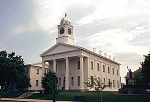
Lafayette County Courthouse in Lexington
|
|

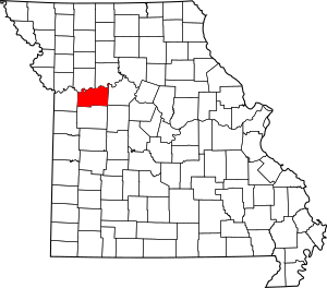
Location within the U.S. state of Missouri
|
|
 Missouri's location within the U.S. |
|
| Country | |
| State | |
| Founded | November 16, 1820 |
| Named for | Marquis de La Fayette |
| Seat | Lexington |
| Largest city | Odessa |
| Area | |
| • Total | 639 sq mi (1,660 km2) |
| • Land | 628 sq mi (1,630 km2) |
| • Water | 11 sq mi (30 km2) 1.6% |
| Population
(2020)
|
|
| • Total | 32,984 |
| • Density | 51.62/sq mi (19.930/km2) |
| Time zone | UTC−6 (Central) |
| • Summer (DST) | UTC−5 (CDT) |
| Congressional district | 5th |
Lafayette County is a county located in the western part of Missouri. It's part of the larger Kansas City metropolitan area, which is a big group of cities and towns connected to Kansas City. In 2020, about 32,984 people lived here.
The main town, or county seat, where the county government is located, is Lexington. Lafayette County was created on November 16, 1820. It was first called Lillard County, named after James Lillard, a person from Tennessee who helped set up Missouri's first government. But on February 16, 1825, its name was changed to Lafayette County. This was to honor the Marquis de La Fayette, a French hero who helped America win the American Revolutionary War. He was visiting the United States at that time.
Contents
History of Lafayette County
Lafayette County was first settled by people who moved from states in the southern U.S., like Kentucky, Tennessee, and Virginia. These settlers brought with them people who were enslaved. They also brought their farming traditions and started growing crops like hemp and tobacco. Because of this, Lafayette County and nearby areas became known as Little Dixie.
By 1860, about a quarter of the county's population was made up of enslaved people. During the American Civil War, the county largely supported the Confederate side.
Later, before and after the Civil War, many new people arrived from Germany. German Americans from St. Louis also moved here. These groups became a big part of the populations in towns like Concordia, Emma, Wellington, Napoleon, Higginsville, Mayview, and Lexington. Most German immigrants supported the Union during the war.
Geography of Lafayette County
Lafayette County covers a total area of about 639 square miles. Most of this, 628 square miles, is land. The remaining 11 square miles, or about 1.6%, is water.
Neighboring Counties
Lafayette County shares borders with several other counties:
- Ray County (to the northwest)
- Carroll County (to the northeast)
- Saline County (to the east)
- Johnson County (to the south)
- Jackson County (to the west)
- Pettis County (to the southeast)
Main Roads
Several important highways pass through Lafayette County, making it easy to travel to and from the area:
 Interstate 70
 U.S. Route 24
 U.S. Route 40
 U.S. Route 65
 Route 13
 Route 23
 Route 131
 Route 224
Protected Natural Areas
Part of the Big Muddy National Fish and Wildlife Refuge is located within Lafayette County. This refuge helps protect wildlife and their habitats.
People of Lafayette County (Demographics)
| Historical population | |||
|---|---|---|---|
| Census | Pop. | %± | |
| 1830 | 2,912 | — | |
| 1840 | 6,815 | 134.0% | |
| 1850 | 13,690 | 100.9% | |
| 1860 | 20,098 | 46.8% | |
| 1870 | 22,623 | 12.6% | |
| 1880 | 25,710 | 13.6% | |
| 1890 | 30,184 | 17.4% | |
| 1900 | 31,679 | 5.0% | |
| 1910 | 30,154 | −4.8% | |
| 1920 | 30,006 | −0.5% | |
| 1930 | 29,259 | −2.5% | |
| 1940 | 27,856 | −4.8% | |
| 1950 | 25,272 | −9.3% | |
| 1960 | 25,274 | 0.0% | |
| 1970 | 26,626 | 5.3% | |
| 1980 | 29,925 | 12.4% | |
| 1990 | 31,107 | 3.9% | |
| 2000 | 32,960 | 6.0% | |
| 2010 | 33,381 | 1.3% | |
| 2020 | 32,984 | −1.2% | |
| U.S. Decennial Census 1790-1960 1900-1990 1990-2000 2010 |
|||
The U.S. Census Bureau collects information about the population every ten years. In 2000, there were 32,960 people living in Lafayette County. This means there were about 52 people for every square mile of land.
The population was made up of different groups. Most people, about 95.52%, identified as White. About 2.27% identified as Black or African American. Smaller percentages identified as Native American, Asian, or Pacific Islander. About 1.17% of the population identified as Hispanic or Latino.
Many families lived in the county. About 33.90% of households had children under 18 living with them. The average household had about 2.55 people. The average age of people in the county was 38 years old.
2020 Census Information
Here's a look at the population breakdown from the 2020 Census:
| Race | Num. | Perc. |
|---|---|---|
| White (NH) | 29,256 | 88.7% |
| Black or African American (NH) | 671 | 2% |
| Native American (NH) | 138 | 0.42% |
| Asian (NH) | 115 | 0.35% |
| Pacific Islander (NH) | 12 | 0.04% |
| Other/Mixed (NH) | 1,745 | 5.3% |
| Hispanic or Latino | 1,047 | 3.2% |
Education in Lafayette County
Lafayette County has several schools, both public and private, to help students learn and grow.
Public Schools
These schools are part of different districts and serve students from kindergarten through high school:
- Concordia R-II School District – Concordia
- Concordia Elementary School (Grades PK-06)
- Concordia High School (Grades 07-12)
- Lafayette County C-1 School District – Higginsville
- Grandview Elementary School (Grades PK-05)
- Lafayette County Middle School (Grades 06-08)
- Lafayette County High School (Grades 09-12)
- Lexington R-V School District – Lexington
- Leslie Bell Elementary School (Grades PK-04)
- Lexington Middle School (Grades 05-08)
- Lexington High School (Grades 09-12)
- Odessa R-VII School District – Odessa
- McQuerry Elementary School (Grades K-02)
- Odessa Upper Elementary School (Grades 03-05)
- Odessa Middle School (Grades 06-08)
- Odessa High School (Grades 09-12)
- Santa Fe R-X School District – Alma
- Santa Fe Elementary School (Grades K-06)
- Santa Fe High School (Grades 07-12)
- Wellington-Napoleon R-IX School District – Wellington
- Wellington-Napoleon Elementary School (Grades PK-06)
- Wellington-Napoleon High School (Grades 07-12)
Private Schools
There are also private schools in the county, often connected to religious organizations:
- Trinity Lutheran School – Alma (Grades K-09) – Lutheran
- Holy Cross Lutheran School – Emma (Grades PK-08) – Lutheran
- Immanuel Lutheran School – Higginsville (Grades K-09) – Lutheran
- Victory Christian Fellowship School – Waverly (Grades K-12) – Nondenominational Christian
- St. Paul Lutheran High School – Concordia (Grades 09-12) – Lutheran
- St. Paul's Lutheran School – Concordia (Grades K-8) – Lutheran
Public Libraries
For reading and research, residents can visit these public libraries:
- Robertson Memorial Library
- Trails Regional Library
Towns and Communities
Lafayette County is home to many different towns and communities:
- Alma
- Aullville
- Bates City
- Blackburn
- Concordia
- Corder
- Dover
- Emma
- Higginsville
- Lake Lafayette
- Lexington (the county seat)
- Mayview
- Napoleon
- Oak Grove
- Odessa
- Waverly
- Wellington
See also
 In Spanish: Condado de Lafayette (Misuri) para niños
 | Janet Taylor Pickett |
 | Synthia Saint James |
 | Howardena Pindell |
 | Faith Ringgold |

