Carroll County, Missouri facts for kids
Quick facts for kids
Carroll County
|
|
|---|---|

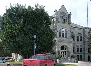
Carroll County Courthouse in Carrollton
|
|

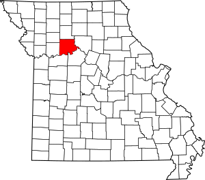
Location within the U.S. state of Missouri
|
|
 Missouri's location within the U.S. |
|
| Country | |
| State | |
| Founded | January 2, 1833 |
| Named for | Charles Carroll of Carrollton |
| Seat | Carrollton |
| Largest city | Carrollton |
| Area | |
| • Total | 701 sq mi (1,820 km2) |
| • Land | 695 sq mi (1,800 km2) |
| • Water | 6.8 sq mi (18 km2) 1.0% |
| Population
(2020)
|
|
| • Total | 8,495 |
| • Density | 12.118/sq mi (4.679/km2) |
| Time zone | UTC−6 (Central) |
| • Summer (DST) | UTC−5 (CDT) |
| Congressional district | 6th |
| Website | http://www.carrollcomo.org/ |
Carroll County is a place in the state of Missouri, USA. It's like a special area within the state, similar to a large town or district. In 2020, about 8,495 people lived here. The main town and government center is called Carrollton.
Carroll County was created on January 2, 1833. It was formed from a part of Ray County. The county is named after Charles Carroll of Carrollton. He was a very important person who signed the Declaration of Independence. This document announced that the United States was a free country.
Contents
Carroll County Geography
Carroll County covers a total area of about 701 square miles. Most of this area, about 695 square miles, is land. The remaining 6.8 square miles, which is about 1% of the total, is water.
Neighboring Counties
Carroll County shares its borders with several other counties:
- Livingston County to the north
- Chariton County to the east
- Saline County to the southeast
- Lafayette County to the southwest
- Ray County to the west
- Caldwell County to the northwest
Main Roads in Carroll County
These are the most important highways that run through Carroll County:
 U.S. Route 24
 U.S. Route 65
 Route 10
 Route 139
Carroll County Population Facts
The number of people living in Carroll County has changed over many years. Here's a look at the population from 1840 to 2020:
| Historical population | |||
|---|---|---|---|
| Census | Pop. | %± | |
| 1840 | 2,423 | — | |
| 1850 | 5,441 | 124.6% | |
| 1860 | 9,763 | 79.4% | |
| 1870 | 17,446 | 78.7% | |
| 1880 | 23,274 | 33.4% | |
| 1890 | 25,742 | 10.6% | |
| 1900 | 26,455 | 2.8% | |
| 1910 | 23,098 | −12.7% | |
| 1920 | 20,480 | −11.3% | |
| 1930 | 19,940 | −2.6% | |
| 1940 | 17,814 | −10.7% | |
| 1950 | 15,589 | −12.5% | |
| 1960 | 13,847 | −11.2% | |
| 1970 | 12,565 | −9.3% | |
| 1980 | 12,131 | −3.5% | |
| 1990 | 10,748 | −11.4% | |
| 2000 | 10,285 | −4.3% | |
| 2010 | 9,295 | −9.6% | |
| 2020 | 8,495 | −8.6% | |
| U.S. Decennial Census 1790-1960 1900-1990 1990-2000 2010-2020 |
|||
In the year 2000, there were 10,285 people living in the county. The population was mostly white, with smaller groups of Black or African American, Native American, and Asian people. A small percentage of the population was also Hispanic or Latino. Many residents had ancestors from Germany, America, England, and Ireland.
The average age of people in the county in 2000 was 40 years old. About 25% of the population was under 18 years old.
Religion in Carroll County
Carroll County is sometimes thought of as being on the northern edge of the "Bible Belt." This is a region where evangelical Protestantism is a very common religion. The most popular religious groups in Carroll County include Southern Baptists, United Methodists, and Lutherans.
2020 Census Update
Here's a quick look at the different racial groups in Carroll County from the 2020 census:
| Race | Num. | Perc. |
|---|---|---|
| White (NH) | 7,906 | 93.1% |
| Black or African American (NH) | 97 | 1.14% |
| Native American (NH) | 15 | 0.2% |
| Asian (NH) | 15 | 0.2% |
| Pacific Islander (NH) | 0 | 0% |
| Other/Mixed (NH) | 330 | 3.9% |
| Hispanic or Latino | 132 | 1.6% |
Education in Carroll County
Carroll County has several school districts that serve its students. These districts help manage the schools in different areas of the county.
School Districts
- Bosworth R-V School District
- Braymer C-4 School District
- Brunswick R-II School District
- Carrollton R-VII School District
- Hale R-I School District
- Norborne R-VIII School District
- Tina-Avalon R-II School District
Public Schools
Here are some of the public schools in Carroll County:
- Bosworth R-V School District in Bosworth
- Bosworth Elementary School (grades PK-6)
- Bosworth High School (grades 7-12)
- Carrollton R-VII School District in Carrollton
- Adams-Dieterich Elementary School (grades K-4)
- Adams Primary School (grades PK-1)
- Carrollton Elementary School (grades 2-4)
- Carrollton Middle School (grades 5-8)
- Carrollton High School (grades 9-12)
- Hale R-I School District in Hale
- Hale Elementary School (grades PK-6)
- Hale High School (grades 7-12)
- Norborne R-VIII School District in Norborne
- Norborne Elementary School (grades K-5)
- Norborne High School (grades 6-12)
- Tina-Avalon R-II School District in Tina
- Tina-Avalon Elementary School (grades PK-6)
- Tina-Avalon High School (grades 7-12)
Public Libraries
If you love to read, Carroll County has public libraries for you to visit:
- Carrollton Public Library
- Norborne Public Library
Communities in Carroll County
Carroll County has different types of communities, from larger cities to smaller villages and unincorporated areas.
Cities
Village
Unincorporated Communities
These are smaller places that are not officially organized as cities or villages:
Townships
Townships are smaller divisions within the county, often used for local administration:
- Carrollton Township
- Cherry Valley Township
- Combs Township
- De Witt Township
- Egypt Township
- Eugene Township
- Fairfield Township
- Hill Township
- Hurricane Township
- Leslie Township
- Moss Creek Township
- Prairie Township
- Ridge Township
- Rockford Township
- Stokes Mound Township
- Sugartree Township
- Trotter Township
- Van Horn Township
- Wakenda Township
- Washington Township
Notable People from Carroll County
Many interesting people have come from Carroll County:
- Lewis Eldon Atherton – A historian who taught at the University of Missouri.
- Amanda Austin – A talented painter and sculptor.
- Leon E. Bates – A leader in the UAW, a big union for car factory workers.
- James Johnson Duderstadt – He was the President of the University of Michigan from 1988 to 1996.
- James Fergason – An inventor and business leader known for his work with LCD technology, which is in many screens today.
- Francis Doyle Gleeson – A Roman Catholic bishop.
- Don Martin – An NFL player and coach.
- John C. McQueen – A Major General in the US Marine Corps and a decorated veteran of World War II.
- James Shields – The only person in U.S. history to serve as a Senator for three different states: Illinois, Minnesota, and Missouri.
- Robert Simpson – A skilled athlete.
- Barbara Sinatra – The wife of famous singers Zeppo Marx and later Frank Sinatra.
- Claude T. Smith – An American band conductor, composer, and educator.
See also
 In Spanish: Condado de Carroll (Misuri) para niños
 | Madam C. J. Walker |
 | Janet Emerson Bashen |
 | Annie Turnbo Malone |
 | Maggie L. Walker |

