Carrollton, Missouri facts for kids
Quick facts for kids
Carrollton, Missouri
|
|
|---|---|

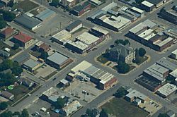
Aerial view of Carrollton, Missouri
|
|

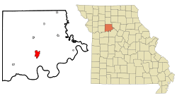
Location of Carrollton, Missouri
|
|
| Country | United States |
| State | Missouri |
| County | Carroll |
| Government | |
| • Type | Mayor-council |
| Area | |
| • Total | 4.18 sq mi (10.84 km2) |
| • Land | 4.17 sq mi (10.80 km2) |
| • Water | 0.02 sq mi (0.04 km2) |
| Elevation | 748 ft (228 m) |
| Population
(2020)
|
|
| • Total | 3,514 |
| • Density | 843.09/sq mi (325.49/km2) |
| Time zone | UTC-6 (Central (CST)) |
| • Summer (DST) | UTC-5 (CDT) |
| ZIP code |
64633
|
| Area code(s) | 660 |
| FIPS code | 29-11566 |
| GNIS feature ID | 2393754 |
Carrollton is a city located in Carroll County, Missouri, in the United States. It's known for winning the All-America City Award in 2005. This award celebrates communities that work together to solve problems. Carrollton is also the county seat of Carroll County. This means it is the main town where the county government is located. In 2020, about 3,514 people lived in Carrollton.
Contents
History of Carrollton
Carrollton was first established in 1833. It got its own post office just one year later, in 1834. The city's growth over time can be seen by looking at old maps. These maps are called Sanborn maps, and some of them are available to view online.
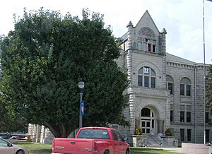
Several important buildings in Carrollton are listed on the National Register of Historic Places. This means they are recognized for their historical value. These buildings include the Carroll County Court House, the Carroll County Sheriff's Quarters and Jail, the United States Post Office, and the Wilcoxson and Company Bank.
Geography and Location
Carrollton is found in the south-central part of Carroll County. It is located where two major roads, US Route 24 and US Route 65, meet. The Missouri River is only about five miles south of the city.
The United States Census Bureau reports that Carrollton covers a total area of about 4.19 square miles (10.84 square kilometers). Most of this area is land, with only a small part being water.
Carrollton's Climate
Carrollton experiences a varied climate throughout the year. The weather changes with the seasons, bringing warm summers and cold winters.
| Climate data for Carrollton, Missouri (1991–2020 normals, extremes 1893–present) | |||||||||||||
|---|---|---|---|---|---|---|---|---|---|---|---|---|---|
| Month | Jan | Feb | Mar | Apr | May | Jun | Jul | Aug | Sep | Oct | Nov | Dec | Year |
| Record high °F (°C) | 74 (23) |
80 (27) |
87 (31) |
93 (34) |
98 (37) |
105 (41) |
114 (46) |
108 (42) |
105 (41) |
94 (34) |
81 (27) |
73 (23) |
114 (46) |
| Mean daily maximum °F (°C) | 37.2 (2.9) |
42.6 (5.9) |
54.5 (12.5) |
65.7 (18.7) |
75.3 (24.1) |
84.3 (29.1) |
88.0 (31.1) |
86.7 (30.4) |
79.8 (26.6) |
67.8 (19.9) |
53.6 (12.0) |
41.8 (5.4) |
64.8 (18.2) |
| Daily mean °F (°C) | 27.3 (−2.6) |
31.9 (−0.1) |
42.7 (5.9) |
53.5 (11.9) |
64.1 (17.8) |
73.6 (23.1) |
77.5 (25.3) |
75.7 (24.3) |
67.7 (19.8) |
55.6 (13.1) |
42.7 (5.9) |
32.1 (0.1) |
53.7 (12.1) |
| Mean daily minimum °F (°C) | 17.4 (−8.1) |
21.1 (−6.1) |
31.0 (−0.6) |
41.3 (5.2) |
52.9 (11.6) |
62.9 (17.2) |
67.0 (19.4) |
64.7 (18.2) |
55.5 (13.1) |
43.4 (6.3) |
31.8 (−0.1) |
22.5 (−5.3) |
42.6 (5.9) |
| Record low °F (°C) | −23 (−31) |
−34 (−37) |
−16 (−27) |
14 (−10) |
28 (−2) |
41 (5) |
47 (8) |
42 (6) |
28 (−2) |
17 (−8) |
−5 (−21) |
−24 (−31) |
−34 (−37) |
| Average precipitation inches (mm) | 1.41 (36) |
1.85 (47) |
2.51 (64) |
3.92 (100) |
5.13 (130) |
5.37 (136) |
4.27 (108) |
4.39 (112) |
4.28 (109) |
3.16 (80) |
2.21 (56) |
1.58 (40) |
40.08 (1,018) |
| Average snowfall inches (cm) | 4.8 (12) |
3.3 (8.4) |
1.1 (2.8) |
0.2 (0.51) |
0.0 (0.0) |
0.0 (0.0) |
0.0 (0.0) |
0.0 (0.0) |
0.0 (0.0) |
0.3 (0.76) |
0.9 (2.3) |
2.1 (5.3) |
12.7 (32) |
| Average precipitation days (≥ 0.01 in) | 5.6 | 5.5 | 8.6 | 10.5 | 12.1 | 10.1 | 8.4 | 8.3 | 7.5 | 8.6 | 6.5 | 5.6 | 97.3 |
| Average snowy days (≥ 0.1 in) | 2.3 | 1.8 | 0.6 | 0.1 | 0.0 | 0.0 | 0.0 | 0.0 | 0.0 | 0.1 | 0.4 | 1.9 | 7.2 |
| Source: NOAA | |||||||||||||
Population Changes (Demographics)
Demographics is the study of how populations change over time. The population of Carrollton has changed quite a bit since 1860. You can see how the number of people living in the city has grown and shrunk over the years in the table below.
| Historical population | |||
|---|---|---|---|
| Census | Pop. | %± | |
| 1860 | 738 | — | |
| 1870 | 1,832 | 148.2% | |
| 1880 | 2,313 | 26.3% | |
| 1890 | 3,878 | 67.7% | |
| 1900 | 3,854 | −0.6% | |
| 1910 | 3,452 | −10.4% | |
| 1920 | 3,218 | −6.8% | |
| 1930 | 4,058 | 26.1% | |
| 1940 | 4,070 | 0.3% | |
| 1950 | 4,380 | 7.6% | |
| 1960 | 4,554 | 4.0% | |
| 1970 | 4,847 | 6.4% | |
| 1980 | 4,700 | −3.0% | |
| 1990 | 4,406 | −6.3% | |
| 2000 | 4,122 | −6.4% | |
| 2010 | 3,784 | −8.2% | |
| 2020 | 3,514 | −7.1% | |
| U.S. Decennial Census | |||
Education in Carrollton
The Carrollton R-VII School District serves the students in Carrollton. This district includes several schools for different age groups.
- Carrollton Area Career Center
- Carrollton High School (for grades 9-12)
- Carrollton Junior High School (for grades 7-8)
- Carrollton Elementary School (for grades Pre-1 and 2-6)
The town also has a public library, called the Carrollton Public Library. It offers books and resources for everyone in the community.
Notable People from Carrollton
Many interesting people have come from Carrollton. Here are a few of them:
- Amanda Austin: A talented painter and sculptor.
- Leon E. Bates: A leader in the UAW, a big union for workers.
- James Johnson Duderstadt: He was the President of the University of Michigan from 1988 to 1996.
- James Fergason: An American inventor and business person who graduated from Carrollton High School in 1952.
- Francis Doyle Gleeson: A Roman Catholic bishop.
- Don Martin: He played as a defensive back for Yale in American football.
- John C. McQueen: A Major General in the U.S. Marine Corps and a decorated veteran of World War II.
- James Shields: A Civil War general and a United States Senator.
- Robert Simpson: An American hurdler and a coach for track and field.
- Claude T. Smith: An American band conductor, composer, and educator.
See also
 In Spanish: Carrollton (Misuri) para niños
 | Claudette Colvin |
 | Myrlie Evers-Williams |
 | Alberta Odell Jones |


