Hale, Missouri facts for kids
Quick facts for kids
Hale, Missouri
|
|
|---|---|

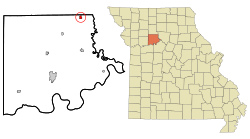
Location of Hale, Missouri
|
|
| Country | United States |
| State | Missouri |
| County | Carroll |
| Area | |
| • Total | 0.55 sq mi (1.42 km2) |
| • Land | 0.55 sq mi (1.42 km2) |
| • Water | 0.00 sq mi (0.00 km2) |
| Elevation | 778 ft (237 m) |
| Population
(2020)
|
|
| • Total | 375 |
| • Density | 683.06/sq mi (263.65/km2) |
| Time zone | UTC-6 (Central (CST)) |
| • Summer (DST) | UTC-5 (CDT) |
| ZIP code |
64643
|
| Area code(s) | 660 |
| FIPS code | 29-29908 |
| GNIS feature ID | 2394268 |
Hale is a small city located in Carroll County, Missouri, in the United States. In 2020, the city had a population of 375 people. It's a quiet place where people live and work.
Contents
History of Hale
Hale was officially planned and marked out on a map in 1833. This process is called "platting." The community was named after John P. Hale. He was an important person in the state government, serving as a state legislator.
Where is Hale Located?
Hale is in the state of Missouri. According to the United States Census Bureau, the city covers a total area of about 0.55 square miles (or 1.42 square kilometers). All of this area is land, meaning there are no large lakes or rivers within the city limits.
Who Lives in Hale?
This section tells us about the people who live in Hale, including how many there are and what the community looks like.
Population Changes Over Time
The number of people living in Hale has changed over many years. Here's a look at the population counts from different census years:
| Historical population | |||
|---|---|---|---|
| Census | Pop. | %± | |
| 1890 | 530 | — | |
| 1900 | 665 | 25.5% | |
| 1910 | 587 | −11.7% | |
| 1920 | 690 | 17.5% | |
| 1930 | 574 | −16.8% | |
| 1940 | 562 | −2.1% | |
| 1950 | 452 | −19.6% | |
| 1960 | 504 | 11.5% | |
| 1970 | 461 | −8.5% | |
| 1980 | 529 | 14.8% | |
| 1990 | 480 | −9.3% | |
| 2000 | 473 | −1.5% | |
| 2010 | 419 | −11.4% | |
| 2020 | 375 | −10.5% | |
| U.S. Decennial Census | |||
In 2000, the average income for a household in Hale was about $24,625 per year. For families, the average income was higher, around $45,250. The average income for each person in the city was about $17,790. About 9.5% of families and 15.6% of all people in Hale lived below the poverty line at that time.
A Look at Hale's People (2010)
The census in 2010 counted 419 people living in Hale. There were 176 households, which are groups of people living together in one home. Out of these, 112 were families.
The city had about 698 people per square mile. There were 209 housing units, like houses or apartments, in Hale.
Most of the people in Hale were White (97.1%). About 2.4% of the population identified as being from two or more races. A small number, 0.5%, were American Indian or Alaskan Native.
- Out of the 176 households:
- 30.7% had children under 18 living with them.
- 44.9% were married couples living together.
- 8.5% were homes where a male was the head of the house, with no wife present.
- 10.2% were homes where a female was the head of the house, with no husband present.
- 36.4% were not considered families (for example, single people living alone).
- About 35.2% of all households were made up of just one person.
- About 34.7% of households had someone living alone who was 65 years old or older.
- The average number of people in a household was 2.38.
- The average number of people in a family was 3.01.
The population in Hale was spread out by age:
- 24.7% were under 18 years old.
- 3.6% were between 19 and 24 years old.
- 24.9% were between 25 and 44 years old.
- 23.6% were between 45 and 64 years old.
- 18.4% were 65 years old or older.
The average age of people in Hale was 38.5 years.
See also
 In Spanish: Hale (Misuri) para niños
 | James Van Der Zee |
 | Alma Thomas |
 | Ellis Wilson |
 | Margaret Taylor-Burroughs |

