De Witt, Missouri facts for kids
Quick facts for kids
De Witt, Missouri
|
|
|---|---|

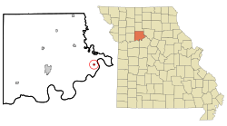
Location of De Witt, Missouri
|
|
| Country | United States |
| State | Missouri |
| County | Carroll |
| Area | |
| • Total | 0.24 sq mi (0.62 km2) |
| • Land | 0.24 sq mi (0.62 km2) |
| • Water | 0.00 sq mi (0.00 km2) |
| Elevation | 745 ft (227 m) |
| Population
(2020)
|
|
| • Total | 83 |
| • Density | 344.40/sq mi (132.89/km2) |
| Time zone | UTC-6 (Central (CST)) |
| • Summer (DST) | UTC-5 (CDT) |
| ZIP code |
64639
|
| Area code(s) | 660 |
| FIPS code | 29-19378 |
| GNIS feature ID | 2394477 |
De Witt is a small city located in Carroll County, Missouri, in the United States. In 2020, the city had a population of 83 people. It's a quiet place with a rich history.
Contents
History of De Witt
The town of De Witt has had a post office since 1842. A post office is where people send and receive mail. The community was named after DeWitt Clinton, who was a very important governor of New York. He was known for helping to build the Erie Canal, which was a big waterway that helped connect different parts of the state.
Geography of De Witt
De Witt is a small city in terms of its size. According to the United States Census Bureau, the city covers an area of about 0.24 square miles (0.62 square kilometers). All of this area is land, meaning there are no large lakes or rivers within the city limits.
People and Population
The number of people living in De Witt has changed over many years. Here's a look at how the population has grown and shrunk since 1860:
| Historical population | |||
|---|---|---|---|
| Census | Pop. | %± | |
| 1860 | 203 | — | |
| 1870 | 317 | 56.2% | |
| 1880 | 530 | 67.2% | |
| 1890 | 633 | 19.4% | |
| 1900 | 550 | −13.1% | |
| 1910 | 423 | −23.1% | |
| 1920 | 360 | −14.9% | |
| 1930 | 371 | 3.1% | |
| 1940 | 314 | −15.4% | |
| 1950 | 254 | −19.1% | |
| 1960 | 174 | −31.5% | |
| 1970 | 135 | −22.4% | |
| 1980 | 132 | −2.2% | |
| 1990 | 125 | −5.3% | |
| 2000 | 120 | −4.0% | |
| 2010 | 124 | 3.3% | |
| 2020 | 83 | −33.1% | |
| U.S. Decennial Census | |||
What the 2010 Census Showed
In 2010, there were 124 people living in De Witt. These people lived in 49 different homes, and 33 of those were families. The city had about 517 people per square mile.
Most of the people in De Witt were White (about 90%). A smaller number were African American (about 6%), and some people were from two or more racial backgrounds (about 4%). Less than 1% of the population was Hispanic or Latino.
Out of the 49 homes, about 33% had children under 18 years old living there. Most homes (about 59%) were married couples living together. A small number of homes had a single parent, either a mother or a father. About 22% of homes were individuals living alone, and some of those were people aged 65 or older.
The average age of people in De Witt in 2010 was about 44 years old. About 26% of residents were under 18, and about 20% were 65 or older. The city had slightly more females (about 52%) than males (about 48%).
See also
 In Spanish: De Witt (Misuri) para niños
 | Stephanie Wilson |
 | Charles Bolden |
 | Ronald McNair |
 | Frederick D. Gregory |

